Karen Still Hanging On…Barely
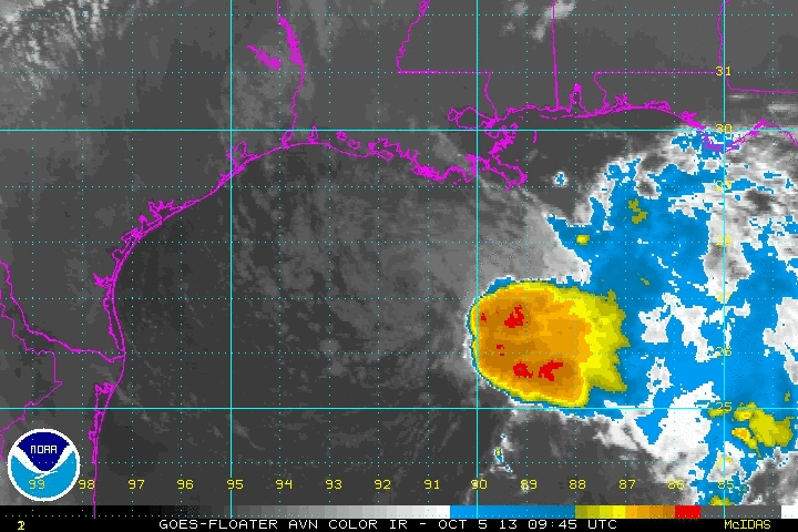
Karen’s center of circulation continues to be well displaced from the main thunderstorm convection. However, throughout the morning hours, a few thunderstorms have been trying to develop near the center and wrap around it. We have seen this similar scenario all week; storms will develop and try to wrap around the center, but are then decimated by dry air and wind shear. This could be Karen’s one last effort to get organized and intensify some before heading towards the Louisiana Coast.
Karen has once again become stationary, but is still expected to start moving to the northeast later today.There are no changes in advisories as the system has stalled and the Hurricane Hunters continue to find a closed circulation as well as tropical storm force winds.
…KAREN STALLS…
…EXPECTED TO MOVE NEAR OR OVER PORTIONS OF SOUTHEASTERN LOUISIANA
TONIGHT AND SUNDAY…
SUMMARY OF 100 PM CDT…1800 UTC…INFORMATION
———————————————-
LOCATION…27.9N 91.8W
ABOUT 130 MI…205 KM SSW OF MORGAN CITY LOUISIANA
ABOUT 190 MI…305 KM WSW OF THE MOUTH OF THE MISSISSIPPI RIVER
MAXIMUM SUSTAINED WINDS…40 MPH…65 KM/H
PRESENT MOVEMENT…STATIONARY
MINIMUM CENTRAL PRESSURE…1009 MB…29.80 INCHES
Category: Alabama's Weather, Tropical
About the Author (Author Profile)
Macon, Georgia Television Chief Meteorologist, Birmingham native, and long time Contributor on AlabamaWX. Stormchaser. I did not choose Weather, it chose Me. College Football Fanatic. @Ryan_StinnetSubscribe
If you enjoyed this article, subscribe to receive more just like it.


