Morning Update
Click image to enlarge
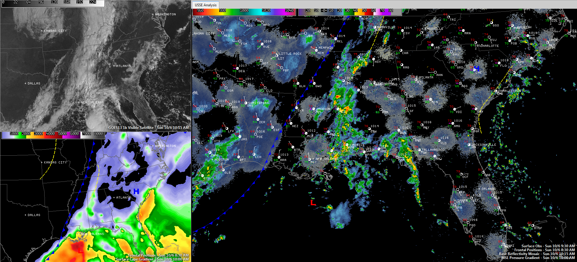
The cold front is marching steadily eastward this morning.
At 10 a.m., it was past Tupelo, Greenwood and Vicksburg. The dewpoint at Tupelo dropped from 70F at 8 a.m. to 59F at 10 a.m.!
To the northwest, the dewpoint was 54F at Memphis and 39F at Harrison AR. The air temperature was 48F at Joplin, MO.
Morning rains brought an inch or more of rain from northern Lamar County through Marion and northwestern Winston County. Some of the heaviest amounts indicated by Doppler radar were over two inches from northeast of Sulligent to between Guin and Hamilton. 1.15 inches of rain measured at the Haleyville Airport this morning.
Ahead of the front, moisture was surging northward over western Alabama and eastern Mississippi. Dewpoints are climbing through the upper 60s and 70s 70s over the western half of the state. A narrow wedge of instability was building from south of Tuscaloosa north northeastward through Jasper to west of Huntsville with CAPE’s climbing above 1,000 j/kg in places.
There is a weak MCV (mesoscale convective vortex) moving into Sumter, Greene and Pickens Counties in West Alabama. It has that meager instability to feed on, and will likely grow into a thunderstorm complex as it moves northeast at 25 mph, but it won’t become severe. As a matter of fact, just noticed first lightning strike south of Livingston in Sumter County. It will push across Tuscaloosa, Hale, Marengo and into Perry and Bibb Counties in the next hour. It could affect the Birmingham Metro around 12:30-1 p.m.
The showers and storms immediately along the front have weakened in the past several hours, but they should gain new energy as they move into the moisture and instability axis over West Alabama.
East of I-65, the air is much drier and sunshine was evident on visible satellite imagery from Cherokee County to Birmingham, Anniston, Selma, Montgomery and Alex City. It will be interesting to see if moisture levels can rise quickly enough to take advantage of the heating going on in East Alabama to produce stronger storms. Even if that happens, they won’t be severe, but could produce some gusty winds.
Still expecting 1.00-1.25 inches of rain across much of Central Alabama from the rain and storms today.
Karen was declared extra-tropical earlier this morning and the remnant low is now near Plaquemines Parish at the southeastern tip of Louisiana. The low is expected to track eastward along the Gulf Coast tonight and Monday.
The rain will end from the west tonight. Estimated timing for the back edge of the rain to reach Tuscaloosa is 7-8 p.m., 10:30-11:30 in Birmingham and 1-2 a.m. in Anniston. Then we will get into a long stretch of as weather that is perfect as you will ever see in Alabama. It will last into next weekend!
Category: Alabama's Weather, Tropical
About the Author (Author Profile)
Bill Murray is the President of The Weather Factory. He is the site's official weather historian and a weekend forecaster. He also anchors the site's severe weather coverage. Bill Murray is the proud holder of National Weather Association Digital Seal #0001 @wxhistorianSubscribe
If you enjoyed this article, subscribe to receive more just like it.


