A Wealth of Weather
I almost feel guilty when I sit and think about the wealth of information available to us as weather humans today. Just sitting at four screens, I can simultaneously see instantly updated displays of winds at 35,000, pressure patterns at 18,000 feet overlain with water vapor satellite imagery, moisture at 10,000 feet, graphic displays of temperature, dew point and precipitable water, a national radar composite, infrared satellite loops (both grayscale and color enhanced) and loops of mesoscale and global models.
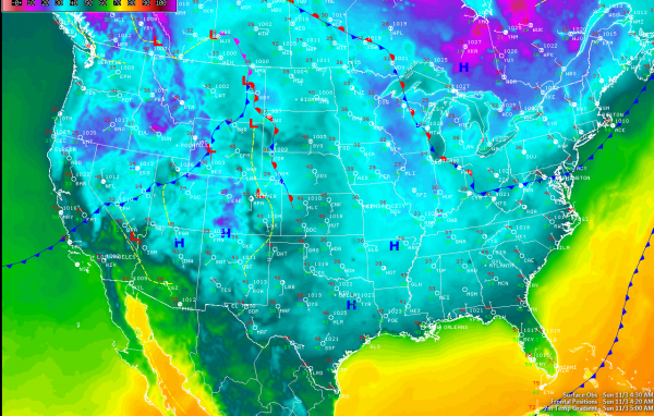
ONE INTERESTING NOTE: I woke early this morning because of the time change and wandered into the weather office. The graphic that caught my attention most of all was a national temperature display. I was struck by the relative uniformity in readings across the country. A teal hue was the dominant color, covering about 85% of the United States and indicating temperatures in the 30s and lower 40s.
Readings in the 50s showed up as more of darker greenish blue, warming up into greens and yellows where readings rose into the 60s and 70s. Only South Florida, the Rio Grande valley of South Texas, the Central Valley of California and the desert areas of southern California and Arizona could boast greens and yellows at 5 a.m. Radars across the country were very quiet this morning, with precipitation limited to light snow showers over the northern Rockies. Winter storm advisories and warnings are in effect for the mountains northern Idaho and western Montana, where 2-7 inches of snow is expected generally above 4,000 feet.
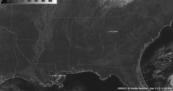
ON ALL THOSE MAPS: There are clear signs that Alabama is having a great November day with lots of sunshine and coolish temperatures. After lows in the upper 30s and lower 40s, temperatures have warmed nicely with total sunshine and dry air in place, rapidly approaching 60F as we close in on the noon hour. There were no clouds over Alabama, although some were trying to develop down into Northeast Alabama from eastern Tennessee. Readings this afternoon will be a couple of degrees warmer than expected, generally in the middle and some lower 60s. Moisture and cloudiness was rapidly spreading across Central Texas. It is moisture from Tropical Storm Sonia, that is expected to turn northeastward and impact the Mexican Coast early Monday morning. Some of these clouds will reach Alabama overnight as they ride up and over the upper ridge of high pressure that is developing over the Arklatex to our west.
MORE NICE WEATHER AHEAD: But the clouds won’t spoil the fine conditions expected through tomorrow and Tuesday and much of Wednesday as well. Skies will be mostly to partly sunny with slowly warming temperatures. Lows tonight will be in the lower 40s tonight, middle 40s Tuesday morning and lower 50s by Wednesday morning as our next storm system approaches. Highs will be in the middle 60s Monday, upper 60s Tuesday and lower 70s Wednesday.
THAT NEXT STORM SYSTEM: By early Wednesday, the upper trough will be swinging into the Texas Panhandle with a surface low over eastern Iowa. A trailing cold front will extend down into northeastern Texas. Showers and storms will be approaching the Mississippi River by sunset. They will spread across Alabama during the pre-dawn and morning hours. Rainfall amounts should average around one half inch. Severe weather is not expected due to limited instability. Cooler and drier air will follow for the weekend.
Category: Alabama's Weather


