

Front Moving Southeast
The cold front is still off to our northwest and it will continue to move southeast overnight.
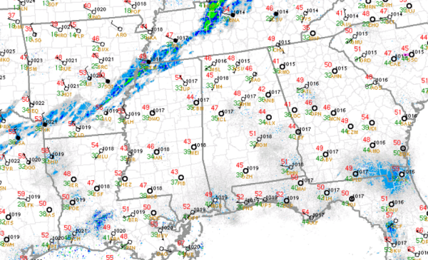
It is currently a crystal clear night across the state, but that will be changing as we head through the overnight hours. Clouds will be increasing and we will see showers move into Alabama after midnight. Temperatures are not too bad as most location remain in the upper 40s currently. Once the front passes through, you will notice the change in temperatures. Temps will head towards the lower 30s by daybreak.
The front is showing up very well on the radar this evening as its uplift is helping produce light showers along the boundary. It is currently across west-central Tennessee, northern Mississippi and southeastern Arkansas. The front has made it through Memphis and will be approaching Alabama after midnight.
Areas across Alabama should see a few rain showers throughout the overnight, and as temps fall, we should see a rain/snow mix and then a complete change-over to all snow. The air over Alabama is very dry and with the very limited moisture, any precip that falls will be light. There could be a few isolated areas of more intense snow bursts that could make it white in some grassy area. However, nothing significant is expected. There are no winter weather advisories in effect anywhere in Alabama.
Category: Alabama's Weather
About the Author (Author Profile)
Macon, Georgia Television Chief Meteorologist, Birmingham native, and long time Contributor on AlabamaWX. Stormchaser. I did not choose Weather, it chose Me. College Football Fanatic. @Ryan_StinnetSubscribe
If you enjoyed this article, subscribe to receive more just like it.


