Arctic Air Returns To Alabama
An all new edition of the ABC 33/40 Weather Xtreme video is available in the player on the right sidebar of the blog. You can subscribe to the Weather Xtreme video on iTunes by clicking here.
TEMPERATURES PLUNGING: As forecast, this day has been very windy, and much colder across the great state of Alabama. In fact, temperatures are now below freezing over the northern third of the state, with wind chill indices in the teens along and north of U.S. 278 (Hamilton to Cullman to Gadsden). North winds of 15-30 mph are making for a very blustery day.
We have had many reports of snow flurries over parts of North and Northeast Alabama earlier today, but those have pretty much vanished.
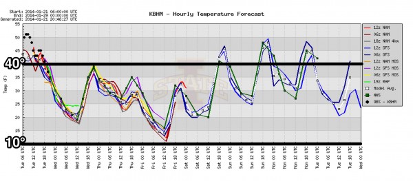
Tonight will be very cold; the sky will be mostly fair and the wind will slowly die down. We project a low early tomorrow between 15 and 19 degrees, and the NWS in Birmingham has issued a “hard freeze warning” for tonight.
Tomorrow will feature a good supply of sunshine, but the weather stays cold with a high in the upper 30s.
EVEN COLDER THURSDAY: The next surge of very cold air arrives Thursday. Sure looks like we will have a hard time rising above freezing both Thursday and Friday; communities north of Birmingham could very well hold in the 20s on both of these days. The coldest morning will come early Friday, when a low between 10 and 15 degrees is likely.
The bottom line is this Arctic blast won’t be quite as cold as the one we saw earlier this month, but it will last longer, and you need to check on elderly people that might not have an adequate source of heat. Don’t forget the pets and pipes.
Sure looks like the next time we rise above 40 degrees will come during the day Saturday, when a warming trend finally begins. The weekend will be dry with a good supply of sunshine both days; the high Saturday will be in the upper 40s, followed by low 50s Sunday.
NEXT WEEK: The new 12Z run of the GFS is advertising yet another shot of Arctic air by Tuesday of next week (January 28) with highs dropping back into the 30s. The persistent pattern of an upper ridge over the western U.S., and an upper trough over the east just won’t change much through the next 15 days. See the Weather Xtreme video for the maps, graphics, and details.
WEATHER BRAINS: Don’t forget you can listen to our weekly 90 minute netcast anytime on the web, or on iTunes. This is the show all about weather featuring many familiar voices, including our meteorologists here at ABC 33/40. Scroll down for the show notes on the new episode we recorded last night.
CONNECT: You can find me on all of the major social networks…
Facebook
Twitter
Google Plus
Instagram
I had a great time today visiting with the kindergarten students at Weaver Elementary School in Calhoun County, and the 2nd graders at Briarwood Christian School in Birmingham. Be looking for them on the Pepsi KIDCAM today at 5:00 and 6:00 on ABC 33/40 News… look for the next Weather Xtreme video here by 7:00 a.m. tomorrow….
Category: Alabama's Weather


