Frigid Air Arrives Tonight; South Alabama Snow Ahead
An all new edition of the ABC 33/40 Weather Xtreme video is available in the player on the right sidebar of the blog. You can subscribe to the Weather Xtreme video on iTunes by clicking here.
THE FUN OF WINTER FORECASTING: Seems these days that armchair meteorologists want to use “wishcasting” methods to somehow bring snow into their part of Alabama. I see so much bad information floating around social media that it is almost scary.
Sure, we can be wrong (we have been wrong before, and will be wrong again), but I assure you we are using sound science and forecast techniques that have generated very high levels of forecast accuracy over the years. Thanks for taking the time to read our forecast products. And, for spreading good information around. The problem with the “wishcasters” is that when their wishcast doesn’t work, then somehow we get the blame. So it goes…
ARCTIC AIR GETTING CLOSER: Temperatures are relatively “mild” at daybreak, with mostly mid to upper 40s across North/Central Alabama. The Arctic front arrives this afternoon; north winds will increase, and temperatures will fall quickly. The NWS in Huntsville has issued a “wind chill advisory” for tonight due to the cold air and strong winds; by daybreak tomorrow we will be close to 20 degrees. A north wind of 10-20 mph will push the wind chill index down into the 0 to 5 degree range.
FRIGID TUESDAY: The cold air deepens tomorrow, and the high will be only in the 30-35 degree range with a north wind of 10-15 mph during the day, keeping the wind chill index below freezing all day.
DEEP SOUTH SNOW: The upper trough axis will be west of Alabama tomorrow, meaning we will have a southwest flow aloft on top of the very cold, Arctic air near the surface. This sets up an overrunning pattern, and will bring wintry precipitation to our state.
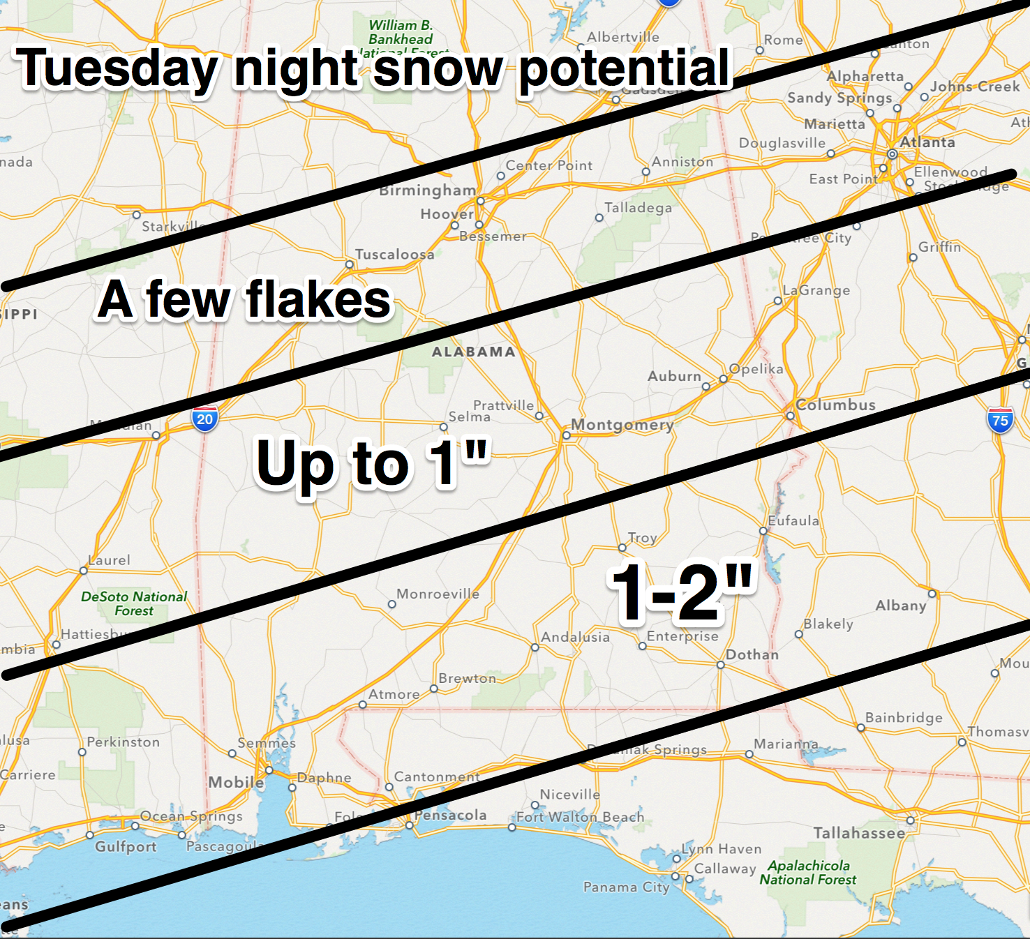
The National Weather Service maintains a Winter Storm Watch for areas south of a line from Demopolis to Clanton to Wedowee for tomorrow and tomorrow night. This watch goes all the way down to the Alabama Gulf Coast.
NORTHERN HALF OF ALABAMA: Light snow or snow flurries will break out during the day tomorrow over North and Central Alabama. Let’s make it perfectly clear… we DO expect some snow for places like Tuscaloosa, Birmingham, Anniston, and Gadsden, but the chance of accumulating snow for these cities is very low. Some spots could see a dusting, but we don’t expect anything more than that. Travel issues are not expected; the big story is the Arctic cold. Light snow is possible for North/Central Alabama anytime tomorrow or tomorrow night, but again, it should be light, spotty, and significant accumulation is not expected.
SOUTHERN HALF OF ALABAMA: This is where you will find the best chance of accumulating snow… generally from Montgomery south. Moisture will be deeper in this part of the state. For Mobile and the Gulf Coast region, precipitation most likely begins tomorrow in the form of rain and sleet, then changing to freezing rain/sleet, and finally snow tomorrow night. There is a very real possibility bridge icing will be severe over South Alabama, including the I-10 Bayway, by tomorrow night and Wednesday morning with temperatures well below freezing. Ice on bridges and overpasses is likely over the rest of South Alabama tomorrow night and early Wednesday, and travel could be impacted in a big way.
Total accumulation of sleet and snow will be in the 1 to 2 inch range over South Alabama, but there could be spots with more. Trying to identify those places with higher snow totals is difficult at this point, but I would not be surprised if some places around Dothan, Ozark, Abbeville, and Eufaula might make a run at three inches in a few spots.
Our overall thinking has not changed….
Some light snow accumulation is very possible for places like Gulf Shores and Pensacola… will be interesting to see if that happens.
IMPORTANT NOTE: There is limited skill in handling winter weather situations in South Alabama simply because of the lack of good analogs. This forecast is subject to change. And, for those of you in South Alabama, some will be severely disappointed in the amount of snow they receive, and others will be delighted. It always works that way with snow events in Alabama. I will have another complete discussion and update here later this afternoon.
WEDNESDAY/THURSDAY: The sky becomes mostly sunny Wednesday as the winter storm moves out. But, we stay cold with a high Wednesday only in the mid 30s. The coldest mornings with the Arctic blast will come early Wednesday and Thursday mornings, with lows between 10 and 15. But, clearly the colder valleys will see single digit lows over North Alabama on these two mornings, much like last week.
Thankfully, a warming trend begins Thursday afternoon with a high around 40 degrees.
FRIDAY AND THE WEEKEND: The big thaw is on. Friday will be partly sunny with a high around 50 degrees, and we go into the upper 50s Saturday, and low to mid 60s Sunday. Moisture will increase over the weekend, and we will need to mention a chance of showers Saturday and Sunday. But, with little dynamic support the rain won’t be too widespread or heavy. Just keep in mind a few passing showers are possible over the weekend with a mostly cloudy sky.
NEXT WEEK: A significant wave will bring the risk of organized showers and thunderstorms to Alabama around Tuesday, followed by a quick shot of cold air.
Take some time to watch the Weather Xtreme video for the maps, graphics, and more details.
WEATHER BRAINS: Don’t forget you can listen to our weekly 90 minute netcast anytime on the web, or on iTunes. This is the show all about weather featuring many familiar voices, including our meteorologists here at ABC 33/40. We produce this week’s show at 8:30 CT tonight; you can watch it on “James Spann 24/7” on cable systems around the state, or on the web here.
CONNECT: You can find me on all of the major social networks…
Facebook
Twitter
Google Plus
Instagram
I have a weather program today at Vestavia Hills Cahaba Heights Elementary School… look for the next Weather Xtreme video here by 4:00 this afternoon. Enjoy the day!
Category: Alabama's Weather
About the Author (Author Profile)
James Spann is one of the most recognized and trusted television meteorologists in the industry. He holds the AMS CCM designation and television seals from the AMS and NWA. He is a past winner of the Broadcast Meteorologist of the Year from both professional organizations.Subscribe
If you enjoyed this article, subscribe to receive more just like it.


