8 p.m. Update
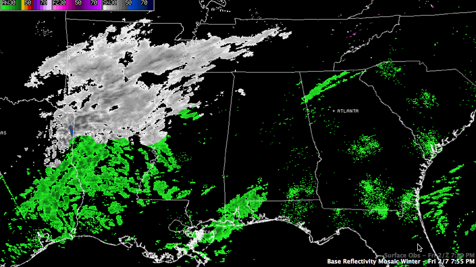
A shield of light precipitation is moving eastward tonight across eastern Oklahoma, eastern Texas, much of Arkansas, as well as much of Louisiana.
Let’s go back to the west and north and look at some reports, forecasts and advisories:
NE TEXAS/NORTHERN LOUISIANA
…Started as big, nickel sized snowflakes in Tyler TX, but became rain. Back to freezing rain just after 6 p.m. with 32F.
…A mix of sleet and freezing rain is expected overnight in the I-20 corridor from Northeast Texas across northern Louisiana in places like Tyler, Shreveport, Ruston and Monroe. Up to 0.10″ inches of ice could accumulate. While this won’t cause major power outages, it will wreak havoc on roads, especially bridges and overpasses.
…Some 1-2″ snow accumulations expected a little further north across extreme NE Texas, eastern Oklahoma and southern Arkansas, including the Texarkana area.
…Rain in Monroe, occasionally mixed with sleet at 7:45.
…Big flakes in Atlanta/Queen City TX at 7:45. Radar shows the bright banding in that area, indicating meting snow, which is probably refreezing in a shallow cold layer near the surface to form sleet. 1.5 inches on the ground in Atlanta TX at 8 p.m.
…Light snow at SHV, but light sleet at nearby Barksdale AFB.
ARKANSAS
…2 inches of snow expected in s strip from Hot Springs to Little Rock to Searcy.
…1 inch of snow elsewhere in a southwest to northeast strip across much of the rest of the state
…1 inch on the ground in North Little Rock and 1.5 inches 10 miles north of Downtown Little Rock at 7:30.
…25F with moderate snow at Hot Springs this hour. Snowing across much of Arkansas this hour.
MEMPHIS AREA/WESTERN TENNESSEE
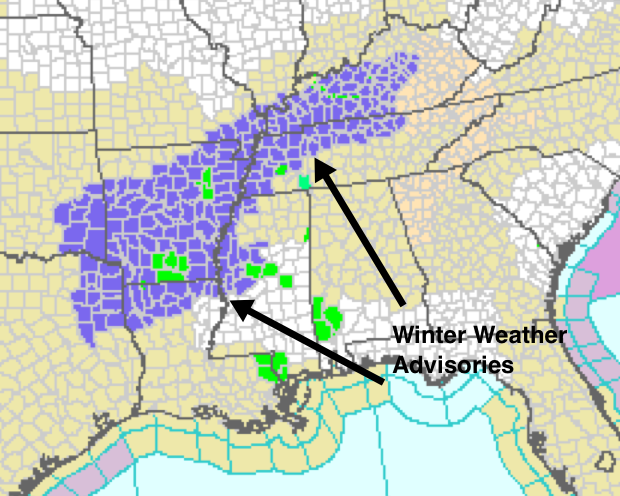
…A winter weather advisory is in effect for cities from Memphis to Dyersburg and Clarksville.
…Areas near and north of I-40 will see 1 to 2 inches of snow.
…Up to an inch of snow is expected elsewhere over southeastern Arkansas into northwestern Mississippi.
…The official forecast calls for 1/2 inch in Memphis.
NORTHERN MISSISSIPPI
…Less than 1/2 inch of snow is expected across the northern tier of Mississippi counties, including places US-82 from Clarksdale to Starkville, including Tupelo.
…Northern Mississippi counties are NOT under a winter weather advisory.
CENTRAL MISSISSIPPI
The NWS Jackson just added more counties to its winter weather advisory. Greenville, Grenada, Greenwood, Yazoo City and Cleveland are in the advisory area along with much of the Delta.
…A wintry mix of freezing rain and sleet will impact this area with slippery spots on bridges and less heavily traveled roads.
…The further north you go in the Delta, up to an inch of snow could fall.
…Sleet was just reported in Vicksburg at 7:40.
…A mix of sleet and snow has been falling across the Delta since about 6 p.m.
…Greenville reports light snow accumulation on elevated surfaces earlier, but moderate snow starting to stick just before 8 p.m. Accumulation: 0.2″. Beginning to accumulate on roads.
MIDDLE TENNESSEE
…1/2 to 2 inches of snow from Waverly to Nashville to Cookeville and northwward into Kentucky.
…Areas from Waynesboro to Murfreesboro to Crossville can expect less than 1/2 inch of snow accumulation.
NORTH ALABAMA
…Light snow is expected to fall across the Tennessee Valley counties of Alabama, where temperatures are already near freezing.
…There are no advisories now, but can’t rule out slick spots on roads overnight, especially along and north of US-278 in Alabama.
FOR US HERE IN CENTRAL ALABAMA
…Light snow will fall later tonight from Lamar and Marion Counties eastward across Winston, Fayette, northern Walker, extreme northern Jefferson, Blount, northern St. Clair, northern Calhoun and into Cherokee Counties. While significant accumulations aren’t expected, there could be slick spots on roads, especially bridges and overpasses after midnight. Lows should be near of just below freezing in these areas.
…Further south, lows will range between 31-34F in the I-20 corridor in places like Tuscaloosa, Birmingham and Anniston southward to Demopolis, Clanton and Alex City. In these areas rain will start after midnight and gradually change to a light mix of rain, sleet, freezing rain and some snow. There could be a few slicks spots, especially on bridges and overpasses during the early morning hours through sunrise. Check weather updates before traveling after midnight tonight into Saturday morning.
…Further south, in Selma, Montgomery an Auburn, the precip should fall mainly as rain.
We will be monitoring the situation all night and will have frequent updates.
Category: Winter Weather
About the Author (Author Profile)
Bill Murray is the President of The Weather Factory. He is the site's official weather historian and a weekend forecaster. He also anchors the site's severe weather coverage. Bill Murray is the proud holder of National Weather Association Digital Seal #0001 @wxhistorianSubscribe
If you enjoyed this article, subscribe to receive more just like it.


