Some Snow into Alabama
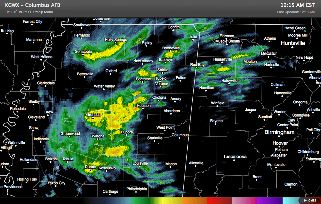
Light snow moved into Northwest Alabama’s Marion County just after 11 p.m. Sleet was reported at Columbus MS in the past few minutes.
The precipitation was increasing according to radar over Franklin, Winston and Marion Counties.
Upstream, areas of light to moderate precipitation covered much of North Central Mississippi from Yazoo City to to Grenada and Houston up to New Albany and Corinth. It is a mix of sleet and snow, leaning heavily to snow the further north you go.
Roads are reportedly snow covered near Ecru in Pontotoc County, MS west of Tupelo. There was accumulation on roads around Oxford as well.
This activity will push northeastward over the next several hours, pushing into West and Northwest Alabama. The airmass is drier over Alabama, but moisture is spreading in from the southwest. This will allow the airmass to saturate and more sleet and snow to reach the ground.
Light precipitation approaching Tuscaloosa was not reaching the ground and dried up as it encountered drier air the further northeast it went.
Temperatures are near freezing now northwest of a line from Columbus MS to Double Springs and Huntsville. The freezing line will slide a little further southeast as evaporational cooling continues, reaching freezing across areas as far southeast as Macedonia, Berry and Cordova.
There could be slick spots on bridges and overpasses overnight in areas from northwestern Pickens County across Fayette, Walker, Cullman and Marshall Counties northward into the Tennessee Valley, including places like Vernon, Hamilton, Haleyville, Double Springs, Fayette, Jasper, and Cullman.
Further southeast to the I-59 corridor, there will be a mix of rain, sleet and snow overnight. But precipitation will be lighter and temperatures will generally stay above freezing. It is 35F at Birmingham, over a dewpoint of 25F, so it will be close to freezing it appears. But the precipitation will be lighter by the time you get to I-59. Road problems will be spotty at best and limited to a few slick spots on bridges and overpasses from Birmingham to Gadsden. .
Just in case, check road conditions before traveling early in the morning, especially over Northwest and North Alabama.
We will have updates through the night.
Category: Alabama's Weather, Winter Weather
About the Author (Author Profile)
Bill Murray is the President of The Weather Factory. He is the site's official weather historian and a weekend forecaster. He also anchors the site's severe weather coverage. Bill Murray is the proud holder of National Weather Association Digital Seal #0001 @wxhistorianSubscribe
If you enjoyed this article, subscribe to receive more just like it.


