

Late Morning Update
We continue to watch a few areas of light rain/sleet/snow moving across northern and central Alabama this morning. A majority of the precip has moved out of the state, but there are still a few light showers ongoing. Temperatures have warmed above the freezing mark, so what precip falls will not be impacting the roadways. The few returns we are seeing on radar will move off to the east and we should all be done with precip during the next few hours. Currently, we are getting radar returns across portions of Etowah, St. Clair, Jefferson, Cullman, Winston and Walker counties.
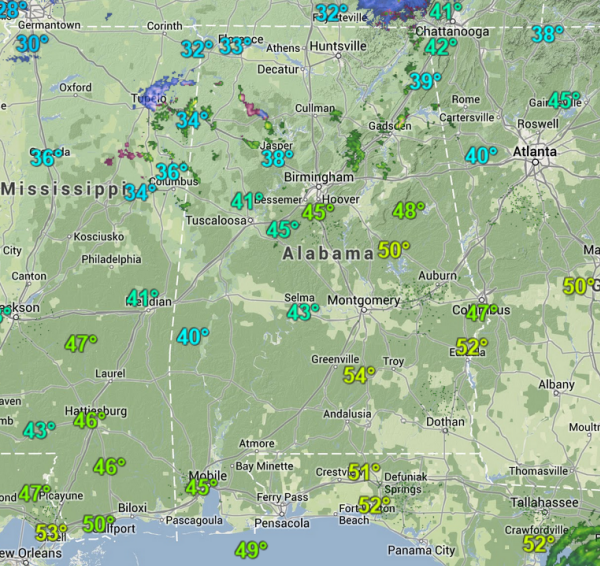
Across southern portions of the state, there is full sunshine and temps are warming well into the 40s and 50s already this morning. The clouds are hanging tough over northern portions of the state. The clouds in the upper-levels will continue to move southwest to northeast across the state today. The lower-level clouds will erode out slowly today and most of Central Alabama will see some sunshine later today. Already a few breaks in the clouds being observed along Interstate 20/59.
All areas are above freezing and temps will continue to warm through the rest of the morning and into the afternoon hours. Temps are expected to reach into the lower 50s along the Interstate 20 corridor. To the north of this area, upper 40s are forecast, while areas along the U.S. 80 and Interstate 85 corridor will be in the mid-to-upper 50s.

Category: Alabama's Weather
About the Author (Author Profile)
Macon, Georgia Television Chief Meteorologist, Birmingham native, and long time Contributor on AlabamaWX. Stormchaser. I did not choose Weather, it chose Me. College Football Fanatic. @Ryan_StinnetSubscribe
If you enjoyed this article, subscribe to receive more just like it.


