

Update at 8:45 p.m.
Many of you have been watching James and Brian on the special live broadcast on the web or on the digital subchannel.
Come join us at 8:30 for WeatherBrains. You can see the show live at live.bigbrainsmedia.com.
SKYCAM READINGS (Temperature/dewpoint)
Birmingham 36/32
Cullman 33/25 Wind: N 7 They will go freezing shortly.
Inverness 35/33
Trussville 34/31
Fayette 37/30
Jasper 36/29
Parrish 35/30
Tuscaloosa 38/30
AIRPORT READINGS
35 BHM
32 Cullman
33 Haleyville
39 Anniston and Tuscaloosa
37 Jasper
33 Haleyville
34 Albertville
Slightly lower dewpoint air will continue to work into the areas north of I-20, allowing temperatures to settle near or just below freezing by after midnight.
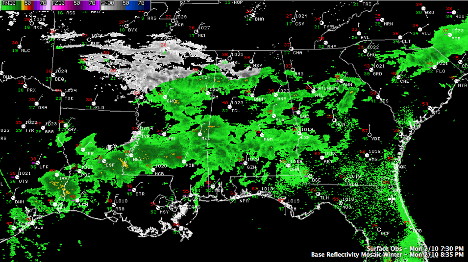
RADAR UPDATE
Scattered showers are falling tonight over North Central Alabama, generally along and south of US-278 from Hamilton to Gassden. Some lighter precip is in the Birmingham Metro area.
Over Mississippi, widespread showers are increasing over Mississippi from Oxford to Yazoo City. This precipitation is poised to move over Alabama through the overnight hours.
Some heavier moisture is moving in from Meridian and East Central Mississippi.
PRECIPITATION TYPE
Some light freezing rain and ice pellets are falling already from eastern Franklin into Lawrence, Limestone, Marion and Winston Counties, perhaps working into northern Walker County. There have even been some reports of snowflakes at Hamilton and near Helena in Shelby County. This freezing and frozen precipitation will expand its coverage overnight with a mix of snow, sleet and freezing rain reaching as far south as Sumter, Greene, Bibb, Shelby, Talladega, Clay and Randoplh Counties. A winter weather advisory is in effect for the aforementioned counties.
A Winter Storm warning covers Marion, Winston, Lamar, Pickens Tuscaloosa, Fayette, Walker, Jefferson, Blount, St. Clair, Etowah, Cherokee, Calhoun and Cleburne Counties through Thursday. Larger accumulations of ice as well significant snow accumulations the further north you go will cause serious problems.
FORECAST UNCHANGED
Scroll down for more info on the current situation. We will be with you all night and through the entire event.
Category: Alabama's Weather
About the Author (Author Profile)
Bill Murray is the President of The Weather Factory. He is the site's official weather historian and a weekend forecaster. He also anchors the site's severe weather coverage. Bill Murray is the proud holder of National Weather Association Digital Seal #0001 @wxhistorianSubscribe
If you enjoyed this article, subscribe to receive more just like it.


