Mild, Unsettled Weather
An all new edition of the ABC 33/40 Weather Xtreme video is available in the player on the right sidebar of the blog. You can subscribe to the Weather Xtreme video on iTunes by clicking here.
RADAR CHECK: Early morning fog gave way to a mostly sunny morning over North/Central Alabama, but clouds returned quickly this afternoon, and showers have formed near a northward moving warm front. Nothing really heavy or widespread; the showers are moving north at 10-20 mph. It is a very mild winter day with temperatures generally in the 67-70 degree range. Anniston hit 71 at one point today.
TONIGHT/TOMORROW: We stay in moist air, and we will maintain the risk of scattered showers with a mostly cloudy sky. The high tomorrow will be up in the low 70s, over ten degrees above average for mid-February in Alabama. The rain won’t be continuous, but just keep in mind a passing shower is possible from time to time.
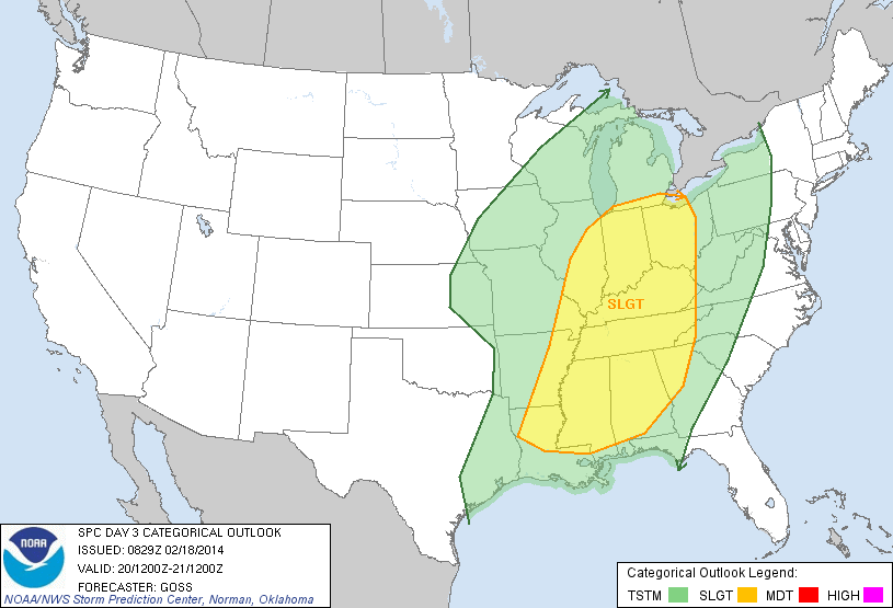
SEVERE WEATHER THREAT THURSDAY NIGHT: Not much change in our thinking on the severe weather situation. The day Thursday will be warm and windy; the GFS is now printing a high of 76 degrees, just two shy of the record high for February 20 (78 set in 1986). A few showers are certainly possible during the day, but the big show comes Thursday night as a dynamic weather system moves into Alabama. SPC maintains the standard “slight risk” of severe weather for much of Alabama…
TIMING: The high resolution NAM model pushes the main line of storms into the northwest corner of Alabama around 6:00 p.m. Thursday. It should reach the Birmingham/Tuscaloosa/Anniston/Gadsden areas in the 8:00 p.m. to 1:00 a.m. time frame. Storms will move out of the state by 3:00 a.m. Friday.
MODES OF SEVERE WEATHER: Clearly the primary threat will come from damaging straight line winds. The low level jet (about 5,000 feet off the ground) will be at or over 50 knots, and that can be pulled down to the surface with the stronger storms. EHI (energy helicity index) values exceed one unit over Alabama during the event, which is significant.
Bulk shear values support an isolated tornado or two if there are breaks in the line. But the primary issue will come from strong winds, possibly high enough to knock down trees and power lines.
We should note the higher severe weather probabilities are over North and West Alabama, generally north of I-59, but severe weather is possible all the way to the Georgia border.
FRIDAY AND THE WEEKEND: The sky will become mostly sunny Friday as drier air returns. It will be a little cooler with a high in the low 60s. The weekend still looks dry for now with a good supply of sunshine both days; the high Saturday will be in the mid 60s, but Sunday looks cooler with a high closer to 60 degrees.
NEXT WEEK: The European model (ECMWF) brings sharply colder air down into Alabama Tuesday as the upper trough becomes re-established over the eastern U.S., and I think that is the right solution. At this point it looks like it will be a mostly dry transition back to cold weather, and thankfully this time the cold air won’t stick around too long. See the Weather Xtreme video for the maps, graphics, and details.
WEATHER BRAINS: Don’t forget you can listen to our weekly 90 minute netcast anytime on the web, or on iTunes. This is the show all about weather featuring many familiar voices, including our meteorologists here at ABC 33/40.
CONNECT: You can find me on all of the major social networks…
Facebook
Twitter
Google Plus
Instagram
I had a great time today visiting with the second graders at Minor Community School… and the third graders at Riverchase Elementary School… be looking for them on the Pepsi KIDCAM today at 5:00 and 6:00 on ABC 33/40 News! The next Weather Xtreme video will be posted here by 7:00 a.m. tomorrow…
Category: Alabama's Weather
About the Author (Author Profile)
James Spann is one of the most recognized and trusted television meteorologists in the industry. He holds the AMS CCM designation and television seals from the AMS and NWA. He is a past winner of the Broadcast Meteorologist of the Year from both professional organizations.Subscribe
If you enjoyed this article, subscribe to receive more just like it.


