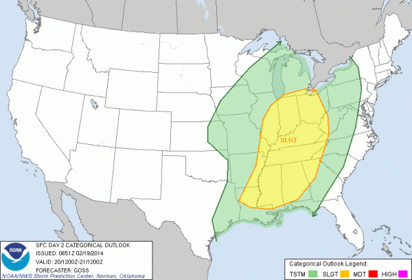
Severe Storms Possible Tomorrow Night
An all new edition of the ABC 33/40 Weather Xtreme video is available in the player on the right sidebar of the blog. You can subscribe to the Weather Xtreme video on iTunes by clicking here.
BALMY WINTER MORNING: Temperatures at daybreak around in the low 60s in most places with a cloudy sky. Just a few showers on radar over Northeast Alabama; interesting to note the NWS in Morristown, TN issued a tornado warning at 5:12 a.m. CT for a number of counties east of Knoxville; I have to wonder if that is the first tornado warning for 2014 for the U.S. We do NOT expect severe weather in Alabama today or tonight.
Today will be mostly cloudy and mild with a high around 70 degrees; scattered showers are possible, but nothing really widespread or heavy.
SEVERE WEATHER RISK TOMORROW NIGHT: The daytime hours tomorrow will feature warm and windy weather conditions; the GFS model is printing a high of 75 degrees, which is within three degrees of the record high of 78 for February 20 (set in 1986). A few showers are possible during the day, but the main storm event comes tomorrow night. SPC maintains the standard “slight risk” of severe weather for much of Alabama.
TIMING: A line of strong to severe storms should begin pushing into the northwest corner of the state tomorrow evening around 6:00 p.m. The storms should reach the Birmingham/Tuscaloosa/Gadsden/Anniston areas in the 8:00 p.m. to 10:00 p.m. time frame. All of the storms will exit the state soon after midnight.
MODES OF SEVERE WEATHER: Clearly, the primary threat will come from strong, perhaps damaging straight line winds. The low level jet (around 5,000 feet off the ground) will be in the 50-60 knot range, and some of that could be transferred down to the surface, meaning wind gusts would be high enough to knock down trees and power lines in a few places.
Bulk shear values are a little lower on the last few model runs, so there is only a low end tornado threat where you find breaks or bows within the line.
A good chance severe weather watches and warnings will be needed, so you know the usual drill; just be sure you can hear those warnings if indeed some are issued. And, a siren is not the way to do that. A NOAA Weather Radio and good smart phone app is the way to go (apps like MyWarn and iMap WeatherRadio).
FRIDAY/SATURDAY: The sky becomes mostly sunny Friday, and the day will be a little cooler with a high around 60 degrees. Saturday looks nice with ample sunshine and a high in the low to mid 60s.
SUNDAY: Model madness continues; the latest GFS run (06Z) now has a Gulf wave again with a chance of rain. The European model (ECMWF) also suggests a chance of rain, but mainly over the southern half of Alabama. I think we will roll with that solution and keep North Alabama dry, while mentioning a chance of rain for the southern counties. The high Sunday will be in the 60s.
NEXT WEEK: Global models rebuild the eastern U.S. upper trough, and colder air will return to Alabama late Tuesday into Wednesday. Doubt if we get past the mid 40s Wednesday with a chilly north breeze, and for now the weather looks generally dry as we make the transition. See the Weather Xtreme video for the maps, graphics, and details.
STORM ALERT 2014. A reminder we have postponed tomorrow’s planned Storm Alert 2014 stop at Shelton State Community College in Tuscaloosa due to the severe weather threat (ironic, huh?). Next week we are coming to Calera High School on Tuesday (Feb 25), and Oxford High School on Thursday (Feb 27). Shows begin at 6:30.
WEATHER BRAINS: Don’t forget you can listen to our weekly 90 minute netcast anytime on the web, or on iTunes. This is the show all about weather featuring many familiar voices, including our meteorologists here at ABC 33/40.
CONNECT: You can find me on all of the major social networks…
Facebook
Twitter
Google Plus
Instagram
I have a weather program this morning at Meadow View Elementary School in Shelby County… be looking for the next Weather Xtreme video here by 4:00 this afternoon. Enjoy the day!
Category: Alabama's Weather


