Warming Trend Begins Tomorrow
An all new edition of the ABC 33/40 Weather Xtreme video is available in the player on the right sidebar of the blog. You can subscribe to the Weather Xtreme video on iTunes by clicking here.
LATE MARCH FREEZE: Here are some observations across Alabama just before daybreak…
Black Creek (just northeast of Gadsden) 18
Valley Head 18
Broomtown 19
Fort Payne 21
Russellville 21
Cottondale 23
Cullman 23
Gadsden 24
Haleyville 24
Fayette 24
Sycamore 25
Concord 25
Bessemer 27
Pleasant Grove 27
Anniston 28
Tuscaloosa 29
Birmingham-Shuttlesworth Airport 29
FYI… the record low for today (March 26) at Birmingham is 22 degrees set in 1955… the “official” observation for Birmingham won’t get that low, but clearly some of the outlying areas are there.
Today will be sunny and cool with a high in the mid 50s, but the wind will be light making the day much more comfortable.
TONIGHT: I think it is important to note that temperatures will fall pretty quickly after sunset this evening, and some of the colder pockets over Northeast Alabama will most likely see another freeze late tonight and early tomorrow. Places like Valley Head and Black Creek… maybe even Gadsden. But Tuscaloosa, Birmingham, and most other places will see a low in the mid 30s, and temperatures will begin to rise after midnight slowly as a south wind begins to kick in.
WARMER TOMORROW: We rise into the 60s tomorrow as a warming trend begins. Moisture levels will rise, and a few isolated showers could show up during the day, but most communities will be dry. Showers become more likely tomorrow night.
RAIN RETURNS: The weather will be mild and unsettled on these two days. A band of showers and storms will move into the state late tomorrow night into Friday morning with a surface front. The main upper support will pass well to the north of Alabama, and with marginal instability values, severe weather is not expected with this first batch of storms. The main chance of rain with this feature will come from about midnight tomorrow night through 12:00 noon Friday. We might even see a few peeks of sunshine Friday afternoon; the high Friday will be in the low to mid 70s.
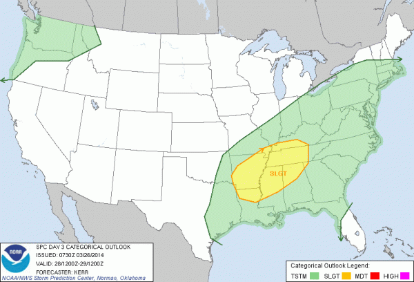
SEVERE STORMS FRIDAY NIGHT/SATURDAY MORNING? A secondary low will form over Arkansas Friday night… moving to Kentucky by Saturday morning. This feature will bring a second round of showers and storms to Alabama, and SPC has decided to issue the standard “slight risk” of severe weather for parts of North Alabama…
The main window for stronger storms with this feature will come from about midnight Friday night through 9:00 a.m. Saturday (we will be able to narrow that down even more later this week). Surface based CAPE values rise to near 750 j/kg, which is adequate for severe storms, but certainly not overwhelming for late March. Wind fields are marginal, but shear values would support organized thunderstorms.
Bottom line is that it looks like a pretty marginal threat for now, but we will keep an eye on it, and you have to respect any weather system in late March and early April since we are in the core of the spring tornado season in Alabama. See the Weather Xtreme video for the maps, graphics, and details.
REST OF THE WEEKEND: We might see a bit of sun Saturday afternoon following the morning storms, but Sunday will be a beautiful day, with sunshine in full supply and a high around 70 degrees.
NEXT WEEK: Dry, mild weather will continue Monday through Wednesday. The GFS continues to suggest another thunderstorm opportunity by late Thursday or Friday of next week; too early to really determine if this will bring a severe weather situation to our state.
AT THE BEACH: Sunny, cool weather for the Gulf coast today from Panama City over to Gulf Shores; the early morning low will near 40, and the high around 60. A shower is possible tomorrow, but showers and storms are more likely Friday and Saturday. Then, the weather looks rain-free Sunday through Wednesday of next week with highs in the 60s on the immediate coast, with 70s inland. Sea water temperatures remain around 60 degrees.
NEED HELP WITH YOUR WEATHER RADIO? We will be at the Publix in Alabaster this afternoon from 3:30 until 6:30 p.m… if you need your weather radio programmed, have questions, or need to buy one, come see us.
WEATHER BRAINS: Don’t forget you can listen to our weekly 90 minute netcast anytime on the web, or on iTunes. This is the show all about weather featuring many familiar voices, including our meteorologists here at ABC 33/40.
CONNECT: You can find me on all of the major social networks…
Facebook
Twitter
Google Plus
Instagram
Look for the next Weather Xtreme video here by 4:00 or so this afternoon…. enjoy the day!
Category: Alabama's Weather


