Showers Arrive Overnight, Storms Tomorrow Night
We are supporting the Spann family as they remain in our thoughts and prayers this evening and the next several days. James’ wife Karen lost her mother earlier today. Please keep their family in your thoughts and prayers as well during this time as they mourn this loss.
We are watching showers and storms developing to our west as they will be heading east during the overnight hours. They will be impacting portions of Alabama likely around midnight. By the time you wake up in the morning, expect widespread showers and perhaps a few thunderstorms to be ongoing to start the day. We are not expecting any severe weather across Central Alabama tonight. The system to our west will be lifting towards the eastern Great Lakes and the better dynamics will be lifting north with it.
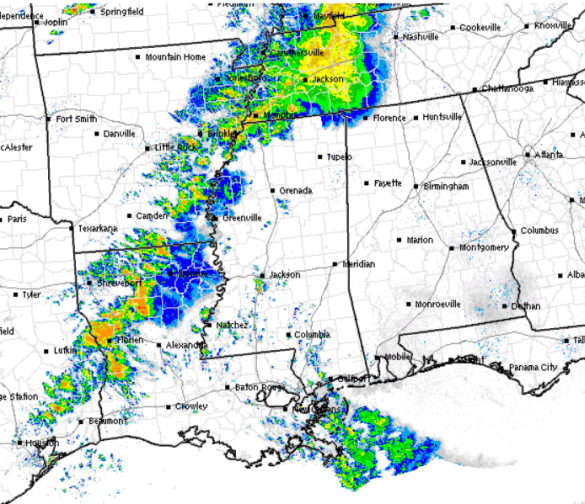
As we head into Friday, the SPC does have the western edge of Alabama included in their standard slight risk for sever weather. Areas along and west of U.S. Highway 43 from Muscle Shoals, down to Fayette, Tuscaloosa, Demopolis, Jackson, and Mobile are included. This risk is not for the activity showing up on radar tonight. Another feature will move across the region tomorrow and will be the reason additional showers and storms develop tomorrow. Most of tomorrow should be okay across the state, the severe weather threat will arrive late tomorrow night and into the early morning hours of Saturday.

The main dynamics and instability with this next system will be to the west of Alabama. Storms are expected to develop over eastern Texas and the ARKLATEX tomorrow afternoon, and will begin to head east. All modes of severe weather will be possible with storms that develop including damaging winds and a few isolated tornadoes, but the main concern appears to be the threat for large hail. As the storms head east through the afternoon and evening, they will likely merge into a line which will possibly heighten the damaging wind threat.
Closer to us in Alabama, a secondary area of low pressure will be developing in the Lower Mississippi Valley. This added shear and uplift will allow for some severe cells to develop over northern Mississippi where the better dynamics will be located. These storms will also likely merge into a line as they head east. The main timing for storms to impact Alabama are 9PM Friday to 4 AM Saturday morning. It does appear the main threats for us in Alabama will be damaging winds and hail. Since we are expecting the bulk of this activity during the overnight hours, make sure you have a way to receive severe weather alerts
SATURDAY: The showers and storms will still be ongoing Saturday morning, but should be exiting the state quickly during the late morning hours. By Saturday afternoon, I think we will begin to see clearing as afternoon highs should be around the 70 degree mark. A front also pushes through Saturday and will bring us a bit of cooler air. Lows Saturday night will likely be in the upper 30s for much of Central Alabama.
THE REST OF THE WEEKEND: Sunday will be a beautiful day across not just Alabama but the entire Southeast. High pressure will build in and will give us several days of warm and dry weather. Afternoon highs will be in the upper 60s and lower 70s while overnight lows should moderate into the lower 50s.
Category: Alabama's Weather
About the Author (Author Profile)
Macon, Georgia Television Chief Meteorologist, Birmingham native, and long time Contributor on AlabamaWX. Stormchaser. I did not choose Weather, it chose Me. College Football Fanatic. @Ryan_StinnetSubscribe
If you enjoyed this article, subscribe to receive more just like it.


