Severe Storms Early Next Week
An all new edition of the ABC 33/40 Weather Xtreme video is available in the player on the right sidebar of the blog. You can subscribe to the Weather Xtreme video on iTunes by clicking here.
DRY THROUGH SUNDAY: As expected, the sky is sunny across Alabama this afternoon with temperatures generally in the 70s, and our weekend weather will be warm and dry with highs up in the low to mid 80s both tomorrow and Sunday. Lots of sun tomorrow… high clouds will begin to arrive Sunday. We do note the 12Z GFS hints at the risk of an afternoon storm near the Mississippi border over West Alabama Sunday afternoon…we will review that possibility and consider putting it in the forecast.
TO THE WEST: A “moderate risk” of severe weather is already up for Sunday that includes much of the Ark-La-Tex region, with a large “slight risk” from East Texas up into the Midwest. A significant severe weather outbreak is likely in this region, and we will be watching with great interest.
THE ALABAMA SEVERE WEATHER THREAT: SPC has the northern and western part of Alabama in a severe weather risk Monday, and a good part of the state in a risk Tuesday.
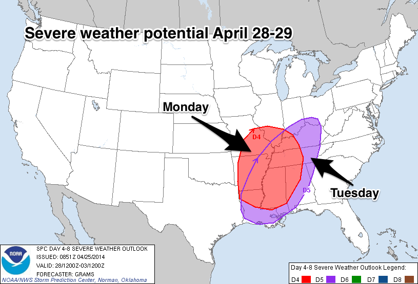
Global model data suggests that the main risk of severe weather Monday and Monday night will be highest for areas north and west of Birmingham… especially the northwest corner of the state up around the Shoals. Monday will be warm and breezy with mid 80s possible, making for a very unstable atmosphere.
All of North and Central Alabama will have a risk of severe weather Tuesday and Tuesday night, and this seems to be the most significant threat for our state. Can’t be much more specific, but based on the forecast instability, shear, and wind field values, all modes of severe weather will be possible, including large hail, damaging winds, and a few tornadoes.
The rain will end from northwest to southeast during the day Wednesday.
FLOODING: Rain amounts of 3 to 5 inches are likely over North-Central Alabama Monday through Wednesday, and people in flood prone areas need to pay close attention to flash flood warnings if they are needed.
Take a few minutes to watch the afternoon edition of the Weather Xtreme video for all of the maps, graphics, and details. This is not an analog to April 27, 2011, but that type of event is generational, and you need to be in a position to hear severe weather warnings, and have a plan and know your safe place. I will write a detailed post on preparation tonight or early tomorrow.
Colder air returns late next week; the 12z GFS is now showing the deeper, colder upper trough again with highs only in the 60s by Friday.
TALLADEGA RACE WEEKEND: At this point, the weekend of May 3-4 looks mild and dry. Can’t be too specific so far in advance, however, and the forecast could change.
WEATHER BRAINS: Don’t forget you can listen to our weekly 90 minute netcast anytime on the web, or on iTunes. This is the show all about weather featuring many familiar voices, including our meteorologists here at ABC 33/40.
CONNECT: You can find me on all of the major social networks…
Facebook
Twitter
Google Plus
Instagram
I enjoyed seeing kids today at Skyland Elementary in Tuscaloosa and Liberty Park Elementary in Vestavia Hills… be looking for them on the Pepsi KIDCAM at 5:00 and 6:00 on ABC 33/40 News! Brian Peters will have the video updates tomorrow and Sunday, my next Weather Xtreme video will be posted bright and early Monday morning by 7:00. Enjoy the weekend!
Category: Alabama's Weather
About the Author (Author Profile)
James Spann is one of the most recognized and trusted television meteorologists in the industry. He holds the AMS CCM designation and television seals from the AMS and NWA. He is a past winner of the Broadcast Meteorologist of the Year from both professional organizations.Subscribe
If you enjoyed this article, subscribe to receive more just like it.


