

Sunshine Returns This Afternoon
RADAR CHECK: As expected, there was no severe weather in Alabama last night or early this morning despite a dynamic weather system approaching; the lack of instability prevented any problems with severe storms. But, gradient winds were gusty, in the 30-35 mph range in spots due to the difference between high pressure to the east, and low pressure to the west.
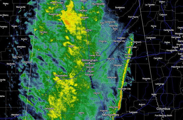
Rain will end from west to east this morning, and most will be in bright sunshine this afternoon as dry air returns. We project a high in the mid 60s today.
TOMORROW: Expect sunshine in full supply. We start the day down in the mid 40s, but temperatures rise quickly, and most places will see a high between 65 and 69 degrees. A very nice December day.
MID-WEEK RAIN: The next weather system will bring clouds back into Alabama Wednesday, and rain is likely Wednesday night into Thursday morning. Some thunder is possible, but severe weather is not expected over the northern half of our state. Rain amounts will be in the 1/2 inch range.
COLDER AIR INVADES ALABAMA: The sky will begin to clear Thursday afternoon following the rain, and cold weather fans will rejoice as we see noticeably colder air for the end of the week. We will drop into the 30-35 degree range by daybreak Friday, and some North Alabama communities won’t get out of the 40s Friday afternoon despite a sunny sky.
THE ALABAMA WEEKEND: Temperatures will be below freezing both Saturday and Sunday morning across North/Central Alabama… the GFS model is printing a low of 31 for Birmingham early Saturday, and 27 early Sunday. The high Saturday will be close to 50, followed by low to mid 50s Sunday. The air will be dry and we are forecasting sunshine in full supply both days. It will feel like Christmas.
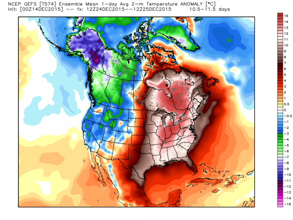
CHRISTMAS WEEK: But, this is Alabama, and it never “gets cold and stays cold”. The El Nino blow torch will bring ridging back to the eastern U.S., and we will warm up again. Looks like we will deal with rain around Tuesday and Wednesday (December 22-23), with a drying trend toward Christmas Day. The pattern favors above average temperatures for the eastern half of the nation on December 25…
If you are looking for cold and snow, head west to the Rocky Mountain States.
AT THE BEACH: Dry tomorrow, then a chance of showers Wednesday night into Thursday. Cool, dry weather is expected for the Gulf Coast Friday and over the upcoming weekend… See the complete Gulf Coast 7 Day Planner here. The Gulf Coast Beach Forecast is presented by Gulf Shores Plantation by Mandoki Hospitality Vacation Rentals. Escape to Gulf Shores Plantation where memories last a lifetime.
WEATHER BRAINS: Don’t forget you can listen to our weekly 90 minute netcast anytime on the web, or on iTunes. This is the show all about weather featuring many familiar voices, including our meteorologists here at ABC 33/40. We will produce this week’s show tonight at 8:30 CT… you can watch it here.
CONNECT: You can find me on all of the major social networks…
Facebook
Twitter
Google Plus
Instagram
Look for the next Weather Xtreme video here by 4:00 this afternoon… enjoy the day!
Category: Alabama's Weather
About the Author (Author Profile)
James Spann is one of the most recognized and trusted television meteorologists in the industry. He holds the AMS CCM designation and television seals from the AMS and NWA. He is a past winner of the Broadcast Meteorologist of the Year from both professional organizations.Subscribe
If you enjoyed this article, subscribe to receive more just like it.


