So Far So Good
The severe thunderstorm warning for Lawrence and Morgan Counties in North Alabama has expired.
A new tornado watch has been issued for Northeast Alabama.
South of there, things are still in pretty good shape, with all storm staying below severe limits for now.
But there is a low level jet across the region, with winds at 5,000 feet running about 60-65 mph. These strong winds will be easily pulled to the surface by a vigorous updraft/downdraft couplet and provide a little extra low level shear for the potential for an isolated tornado. or two.
It is interesting to note that temperatures have risen during the evening hours at Tuscaloosa. Winds have become quite gusty there as well. That is the effect of the low level jet.
At Birmingham, at sunset it was 64F with a dewpoint of 63F. Now is is 73F with a depwoint of 70F.
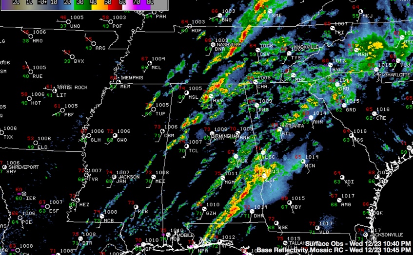
At 10:35 p.m. thunderstorms extend from Pickens, through northwestern Tuscaloosa into Fayette, Walker and Winston Counties. The watch continues for the following counties.
The storms over Fayette and Walker Counties are the strongest and have the best chance of becoming severe.
Elsewhere, scattered showers and storms continue over eastern and Southeast Alabama.
A tornado watch continues until 4 a.m. for areas generally along and west of I-65 in Central Alabama. Lamar and Marion have been cleared.
Stay weather aware overnight and have a way to receive warnings even when you are asleep.
Category: Alabama's Weather, Severe Weather
About the Author (Author Profile)
Bill Murray is the President of The Weather Factory. He is the site's official weather historian and a weekend forecaster. He also anchors the site's severe weather coverage. Bill Murray is the proud holder of National Weather Association Digital Seal #0001 @wxhistorianSubscribe
If you enjoyed this article, subscribe to receive more just like it.


