Strong Storms Tomorrow Evening
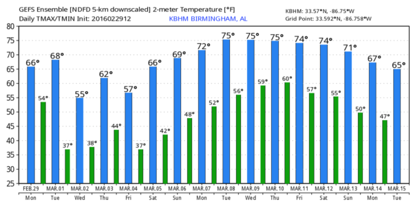
LAST DAY OF METEOROLOGICAL WINTER: It actually feels more like the first day of spring; with a good supply of sunshine temperatures are in the 68-72 degree range across most of North/Central Alabama this afternoon. Nothing is showing up on radar.
ACTIVE WEATHER TOMORROW EVENING: A digging upper trough will support a surface low that will pass well to the north of Alabama tomorrow; it drags a cold front through here tomorrow night. Ahead of the front, a band of showers and thunderstorms is likely. Some of those storms could be strong to severe.
The low level jet will ramp up to over 50 knots, and bulk shear values (over 50 knots) will certainly support a few rotating updrafts. But, the limiting factor is the instability; surface dew points are not expected to get out of the 50s.
TIMING: A few severe storms could enter Northwest Alabama as early as 2:00 tomorrow afternoon… the band of storms will move southeast through the evening, with the risk winding down around 10:00.
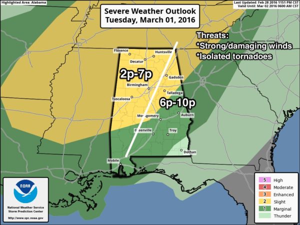
THREATS: The core threat will come from strong, perhaps damaging straight line winds as the line of storms passes through, although an isolated tornado is not out of the question.
RAIN AMOUNTS: Rain totals will be in the 1/2 to 3/4″ range, not enough for major flooding concerns.
WEDNESDAY: Expect a mostly sunny and cool day with a high in the mid 50s.
THURSDAY: Another fast moving weather system will bring clouds back to the state, along with showers by afternoon and into Thursday night. For now it looks like the best chance of rain will come from about 3:00 until 10:00 p.m. Severe storms are not expected, although a little thunder is possible. Rain amounts should be around 1/2 inch.
FRIDAY THROUGH THE WEEKEND: Sunny days, clear nights, and a warming trend. The high Friday will be in the 57-60 degree range, followed by mid 60s Saturday, and upper 60s Sunday.
NEXT WEEK: Dry, mild weather continues Monday… looks like the next chance of showers and storms will come toward the end of the week. See the Weather Xtreme video for maps, graphics, and more details.
WEATHER BRAINS: Don’t forget you can listen to our weekly 90 minute netcast anytime on the web, or on iTunes. This is the show all about weather featuring many familiar voices, including our meteorologists here at ABC 33/40. We will produce this week’s show tonight at 8:30 CT… you can watch it here.
CONNECT: You can find me on all of the major social networks…
Facebook
Twitter
Google Plus
Instagram
I had a great time today seeing kids at Elvin Hill Elementary in Columbiana, and McElwain Christian Academy in Birmingham… be looking for them on the Pepsi KIDCAM today at 5:00 and 6:00 on ABC 33/40 News! The next Weather Xtreme video will be posted here by 7:00 a.m. tomorrow…
Category: Alabama's Weather
About the Author (Author Profile)
James Spann is one of the most recognized and trusted television meteorologists in the industry. He holds the AMS CCM designation and television seals from the AMS and NWA. He is a past winner of the Broadcast Meteorologist of the Year from both professional organizations.Subscribe
If you enjoyed this article, subscribe to receive more just like it.


