Strong Storms Late Tomorrow
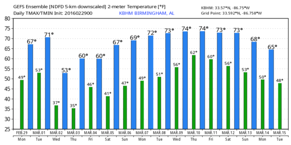
MOSTLY DRY TODAY: We project a high between 67 and 70 degrees this afternoon across the great state of Alabama; the sun should be out at times, but we expect more clouds than sun. A few isolated showers could form this afternoon or tonight, but the chance of any one spot getting wet is only in the 10-20 percent category.
Tomorrow will be unseasonably mild; we reach the low to mid 70s by afternoon.
SEVERE STORMS TOMORROW EVENING: An upper trough will dig down through the Mississippi Valley, and a surface low moves from Tennessee to Pennsylvania; this will bring some risk of strong storms to Alabama late tomorrow afternoon and early tomorrow night.
I would not call this a “major” threat at all; this is not a very favorable pattern for a big severe weather event in Alabama, and surface dew points never get out of the 50s, limiting the amount of instability. However, bulk shear values are relatively high, and it is very possible we could see a few storms at severe limits over the northern half of Alabama.
TIMING: The main risk of strong to severe storms will come from roughly 4:00 p.m. until 10:00 p.m.
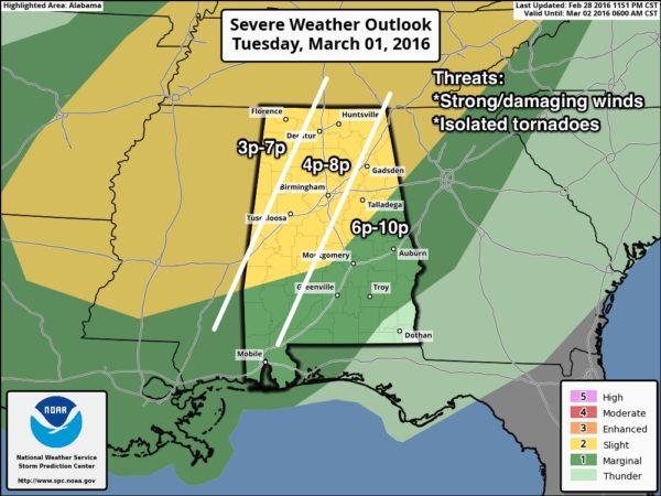
THREATS: The main issue will be strong, perhaps damaging straight line winds with thunderstorms, but an isolated tornado or two can’t be ruled out.
RAIN AMOUNTS: Rain totals of 1/2 to 3/4″ are expected, not enough to bring flooding issues.
WEDNESDAY: The day will be dry and cooler with a good supply of sunshine and a high in the mid 50s.
THURSDAY: A wave will bring a chance of showers, and possibly a thunderstorm, to Alabama. Best chance of rain will come from 3:00 p.m. until midnight, and no severe weather is expected.
FRIDAY AND THE WEEKEND: Fine weather… sunny days, clear nights, and a warming trend. The high Friday will be close to 60, followed by mid 60s Saturday, and upper 60s Sunday. Very similar to the weather we enjoyed this past weekend.
NEXT WEEK: We stay dry Monday, but some risk of showers and storms will return by mid-week… see the Weather Xtreme video for maps, graphics, and more details.
LONG RANGE: We always have late season cold snaps in Alabama in March and April, but no real sign of one for the next 15 days…
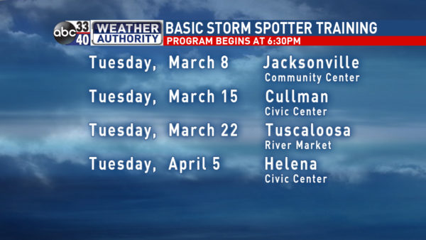
STORM SPOTTER TRAINING: We are offering basic SKYWARN training at four locations across North/Central Alabama in March and April, followed by the big event, Storm Spotter Xtreme on Saturday, April 9 at the BJCC from 9am to 2pm. This will feature both the basic and advanced SKYWARN classes, along with a session from Kevin Laws of the Birmingham NWS office. And, if you come, you get free admission to the Alabama International Auto Show, going on at the BJCC that same day. There is no cost and no need to register. Just show up with a curious mind. Kids 10 and older will also enjoy this if they love weather and want to learn more. Please help us make the severe weather warning process better!
WEATHER BRAINS: Don’t forget you can listen to our weekly 90 minute netcast anytime on the web, or on iTunes. This is the show all about weather featuring many familiar voices, including our meteorologists here at ABC 33/40. We will produce this week’s show tonight at 8:30 CT… you can watch it right here.
CONNECT: You can find me on all of the major social networks…
Facebook
Twitter
Google Plus
Instagram
I hav stops today at Elvin Hill Elementary in Columbiana, and McElwain Christian School in Birmingham… look for the next Weather Xtreme video here by 4:00 this afternoon. Enjoy the day!
Category: Alabama's Weather
About the Author (Author Profile)
James Spann is one of the most recognized and trusted television meteorologists in the industry. He holds the AMS CCM designation and television seals from the AMS and NWA. He is a past winner of the Broadcast Meteorologist of the Year from both professional organizations.Subscribe
If you enjoyed this article, subscribe to receive more just like it.


