Shower Coverage Higher By The Weekend
SCATTERED STORMS: Today is the first day of meteorological summer, and we have a very summer feel to the weather today. Hot, humid, a partly sunny sky, and a handful of widely scattered, but strong storms. Most of the storms are over East and North Alabama at mid-afternoon, showing very little movement…
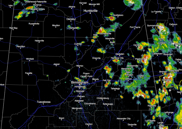
These will fade away once the sun goes down later this evening.
TOMORROW/FRIDAY: Not much change; mixed sun and clouds both days with “scattered, mostly afternoon and evening showers and thunderstorms”. The high will be close to 90 degrees.
THE WEEKEND: Showers and storms should increase in coverage both days as the upper ridge breaks down, and a surface front approaches. Rain distribution in summer is never even, but most places should see a decent downpour or two with average amounts of 1/2 to 3/4 inch. There could be a few strong storms both days, especially Sunday. And, heat levels come down due to the increased cloud cover and showers; the high Saturday will be in the mid 80s, with low 80s Sunday. Some spots over North Alabama could hold in the 70s all day Sunday.
NEXT WEEK: Dry air moves in. The first half of the week will feature sunny days, cooler nights, and lower humidity levels. Many places will see a low down in the 50s by early Tuesday morning. Heat levels rise by Thursday and Friday, but for now the pattern looks pretty dry on those two days. See the Weather Xtreme video for maps, graphics, and more details.
GULF OF MEXICO TROPICAL MISCHIEF NEXT WEEK: Both the GFS and the ECMWF (European) show a tropical low forming in the southern Gulf of Mexico Monday (June 6), moving northeast. This could bring a day or two of enhanced rain coverage for the Florida Peninsula (especially Tampa, Orlando, and Daytona Beach south), but this should not effect for Central Gulf Coast, including the Florida Panhandle.
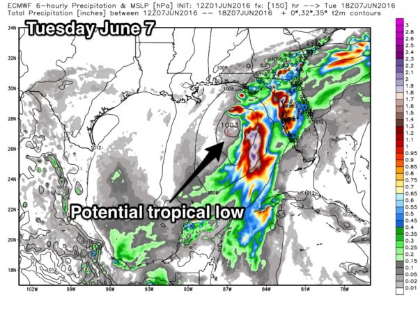
And, if this scenario is correct, no impact on any part of Alabama.
AT THE BEACH: Mostly sunny days and fair nights on the Gulf Coast (Panama City Beach west to Gulf Shores) through Friday with only isolated showers and storms. Then, about 4-6 hours of sunshine both Saturday and Sunday with scattered showers and storms possible both days. Next week is looking generally rain-free. Highs in the 80s on the immediate coast, with low 90s possible inland. See a very detailed Gulf Coast forecast here.
WEATHER BRAINS: Don’t forget you can listen to our weekly 90 minute netcast anytime on the web, or on iTunes. This is the show all about weather featuring many familiar voices, including our meteorologists here at ABC 33/40.
CONNECT: You can find me on all of the major social networks…
Facebook
Twitter
Google Plus
Instagram
Look for the next Weather Xtreme video here by 7:00 a.m. tomorrow…
Category: Alabama's Weather
About the Author (Author Profile)
James Spann is one of the most recognized and trusted television meteorologists in the industry. He holds the AMS CCM designation and television seals from the AMS and NWA. He is a past winner of the Broadcast Meteorologist of the Year from both professional organizations.Subscribe
If you enjoyed this article, subscribe to receive more just like it.


