Rain Returns To Alabama This Week
THE ALABAMA WEATHER SITUATION: Needless to say, all eyes are still on Tropical Storm Harvey and the situation in Southeast Texas. Here in Alabama, we will see a mostly cloudy sky today, and a few sprinkles are possible across the western counties of the state. But, most communities will be dry despite the clouds. The high today will be at or just over 80 degrees.
Pretty much the same thing tomorrow; some patchy light rain is possible, but nothing especially widespread.
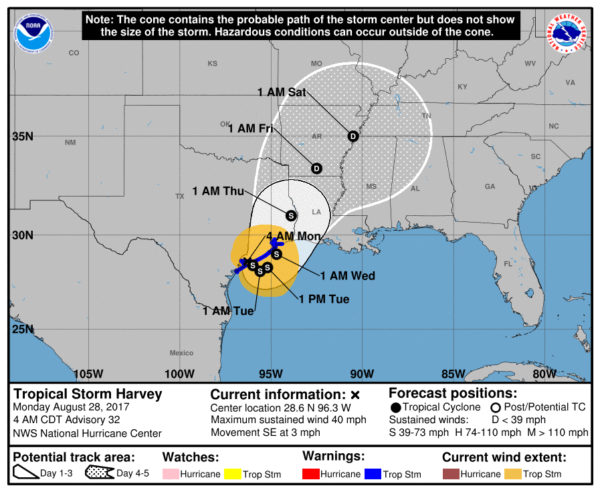
RAIN CHANCES INCREASE LATER THIS WEEK: As Harvey begins to move northeast, tropical moisture will increase across the Deep South, and our weather looks pretty wet Wednesday through Friday with periods of rain and possibly a thunderstorm along the way. The official NHC track puts Harvey near Memphis Friday night, and with us being in the southeast quadrant of the system it might open the door for a low end tornado threat Friday across parts of North or West Alabama. There is still uncertainty in this track; we note the GFS keeps the circulation center over the northeast corner of Texas Friday night, which would mean no tornado issues here. We will fine tune the threat as the week progresses.
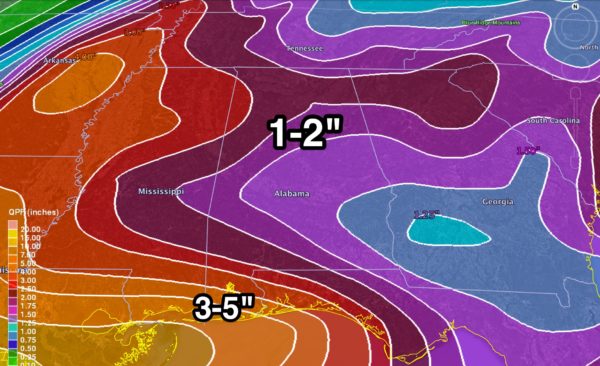
We need to mention here that we don’t expect any flooding issues across the northern half of Alabama; rain amounts of 1-2 inches are expected over the next seven days…
LABOR DAY WEEKEND: The general idea is that the weekend begins wet, and then trends drier. We will maintain a good chance of rain at times Saturday as the remnant circulation of Harvey passes northwest of Alabama, but showers should become fewer in number, and some sun is certainly possible Sunday and Monday. Highs for the weekend will be in the 80s. Just understand with a tropical system involved this forecast could change one way or another as we get closer to the weekend.
GULF COAST WEATHER: Deep tropical moisture will cover the coast this week. A few shower are possible today; then we expect occasional rain and thunderstorms each day tomorrow through Friday. The rain could be heavy at times; rain amounts of 3-5 inches are possible for the Alabama Gulf Coast through Friday, with lighter amounts to the east across the Florida Panhandle.
For the Labor Day weekend, showers and storms remain likely Saturday on the coast, followed by a trend toward drier weather Sunday and Monday. Again, this forecast could change as the weekend approaches. Much depends on the behavior of Harvey.
Click here to see the AlabamaWx Beach Forecast Center page. The Beach Forecast is partially underwritten by the support of Brett/Robinson Vacation Rentals in Gulf Shores and Orange Beach. Click here to see Brett/Robinson’s Hot Deals now!
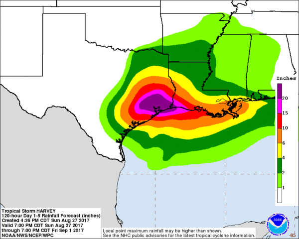
THE LATEST ON HARVEY: The tropical storm is over Matagorda Bay, Texas this morning with sustained winds of 40 mph… and it is nearly stationary. Parts of Houston have received over 20 inches of rain so far, and additional amounts of 20 inches are possible in a few places. Looks like storm totals (by the end of this week) will wind up in the 20-30 inch range for most places, with isolated amounts to 40 inches.
The circulation center is expected to finally move away from the region later this week, winding up near Memphis late Friday night as a tropical depression. The risk of heavy rain and a few isolated tornadoes will continue along and east of the track this week.
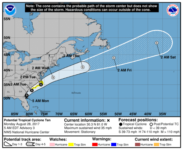
HERE COMES IRMA: “Potential Tropical Cyclone 10” is just east of Jacksonville, Florida early this morning, and is expected to become Tropical Storm Irma within the next 24 hours. This will scoot along the coast of the Carolinas before heading out to the North Atlantic. No impact on Alabama weather.
ANOTHER WAVE TO WATCH: A new tropical wave has emerged off the coast of Africa, and has a decent chance of developing over the next five days as it moves west/northwest across the open Atlantic. Way too early to know if this will impact the Caribbean/Gulf of Mexico, or if it recurves over the open Atlantic. If this becomes a tropical storm, the name will be Jose.
WEATHER BRAINS: Don’t forget you can listen to our weekly 90 minute netcast anytime on the web, or on iTunes. This is the show all about weather featuring many familiar voices, including our meteorologists here at ABC 33/40. We will produce this week’s show tonight at 8:30p CT… you can watch it live here.
CONNECT: You can find me on all of the major social networks…
Facebook
Twitter
Google Plus
Instagram
Pinterest
Snapchat: spannwx
Look for the next Weather Xtreme video here by 4:00 this afternoon… enjoy the day…
Category: Alabama's Weather, ALL POSTS, Weather Xtreme Videos
About the Author (Author Profile)
James Spann is one of the most recognized and trusted television meteorologists in the industry. He holds the AMS CCM designation and television seals from the AMS and NWA. He is a past winner of the Broadcast Meteorologist of the Year from both professional organizations.Subscribe
If you enjoyed this article, subscribe to receive more just like it.


