Potential For A Few Tornadoes Across Alabama Today
ACTIVE WEATHER DAY: The remnant circulation of former Tropical Storm Harvey is over Central Louisiana this morning; it will move northeast across North Mississippi and West Tennessee over the next 18 hours, putting Alabama in a favorable position for numerous showers and thunderstorms. It won’t rain all day, but it will rain at times, and a few storms could be severe.
SPC has roughly the northern half of the state in the standard “slight risk” today… with a “marginal risk” down into South Alabama.
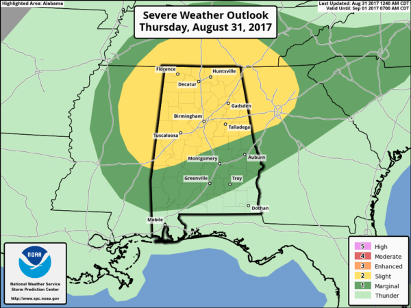
The threat comes from the possibility of a few tornadoes in the heavier storms. Low level shear values will be pretty high, thanks to the tropical system to the west. Instability is the big question mark; if the sun can break out and we warm up into the mid to upper 80s, that will certainly increase the tornado threat.
The main window for severe storms and a few isolated tornadoes will come from about 12:00 noon until 8:00 p.m. And, we need to stress this is not like the setups we have in spring and fall, most tornadoes that form in situations like this tend to be the smaller ones, and rather short lived. But, still dangerous.
And, many of these are low topped, and sometimes can’t be easily identified on radar. Meaning, it is a big challenge to provide timely warnings. Just be very weather aware today and we will watch the radar like a hawk.
Additional rain amounts of around one inch are likely through midnight; for now flash flooding issues are not expected. The heavier rains associated with the core of Harvey’s circulation will stay west and northwest of Alabama.
TOMORROW: As Harvey lifts away from Alabama, a nice dry slot will move into the state. Best chance of showers will be over the far northern counties, near the Tennessee border. Most of Central Alabama should be dry with only a slight risk of a shower; the sky will be partly sunny with a high in the low 80s.
LABOR DAY WEEKEND: We expect mostly sunny warm days, fair cool nights through Monday. A few scattered showers and storms are possible down over far South Alabama, but even there most of the weekend will be dry. Highs will be in the 80s, and lows down in the pleasant upper 50s and low 60s.
FOOTBALL WEATHER: Mostly fair for the high school games Friday night with temperatures falling through the 70s.
Alabama travels to Atlanta to take on Florida State Saturday (7:00 p.m. CT kickoff on ABC 33/40); the game will be played in the new Mercedes-Benz stadium indoors. Outside, it now looks like the waether will be dry Saturday and Saturday night.. temperatures will reach the low to mid 80s in Atlanta Saturday afternoon.
Auburn will host Georgia Southern Saturday evening at Jordan-Hare Stadium (6:30p CT kickoff)… we now project a mostly fair sky.. the kickoff temperature will be near 80 degrees, falling into the low 70s by the final whistle.
UAB will host Alabama A&M Saturday afternoon at Legion Field (2:30p CT kickoff on WABM, MY68)… with a partly to mostly sunny sky temperatures will be around 85 degrees at kickoff, falling to near 80 by the end of the game.
LABOR DAY WEEKEND AT THE BEACH: Partly to mostly sunny weather Saturday through Monday from Gulf Shores west to Panama City Beach; just a few widely scattered showers or storms each day. Highs in the 80s.
NEXT WEEK: A cold front will pass through with a chance of showers and storms Tuesday night or Wednesday, followed by a nice surge of cooler air for the latter half of the week.
IRMA ALMOST A HURRICANE: Tropical Storm Irma is packing sustained winds (estimated) at 70 mph… and should become a hurricane later today or tonight in the eastern Atlantic.
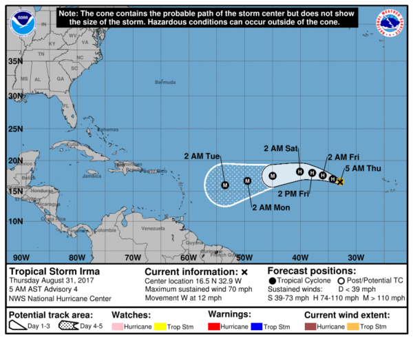
It is WAY too early to know where this winds up. The GFS ensemble suggests it will begin to gain latitude, and potentially recurve off the Atlantic coast of the U.S. in 7-10 days. However, the reliable European model keeps it at a lower latitude, and hints it might stay well under the eastern U.S. upper trough next week. The 00Z Euro has it over Cuba on Saturday September 9. We will keep watching.
A tropical low could form in the Gulf of Mexico next week; if that happens most likely it will be absorbed by a cold front and won’t impact Houston or Port Arthur. And, a new tropical wave is emerging off the coast of Africa. All of this is to be expected since we are nearing the peak of the hurricane season. See the Weather Xtreme video for maps, graphics, and more details.
WEATHER BRAINS: Don’t forget you can listen to our weekly 90 minute netcast anytime on the web, or on iTunes. This is the show all about weather featuring many familiar voices, including our meteorologists here at ABC 33/40.
CONNECT: You can find me on all of the major social networks…
Facebook
Twitter
Google Plus
Instagram
Pinterest
Snapchat: spannwx
Look for the next Weather Xtreme video here by 4:00 this afternoon… enjoy the day!
Category: Alabama's Weather, ALL POSTS, Weather Xtreme Videos
About the Author (Author Profile)
James Spann is one of the most recognized and trusted television meteorologists in the industry. He holds the AMS CCM designation and television seals from the AMS and NWA. He is a past winner of the Broadcast Meteorologist of the Year from both professional organizations.Subscribe
If you enjoyed this article, subscribe to receive more just like it.


