

Eyes On Irma; Alabama To Stay In Dry Air
SURE FEELS LIKE FALL: We are enjoying our coolest morning since last spring… here are some temperatures across Alabama just before daybreak…
Black Creek 45
Fort Payne 45
Cullman 46
Springville 46
Crossville 46
Clay 47
McCalla 48
Concord 48
Haleyville 48
Pell City 48
Today will feature sunshine in full supply with a high in the upper 70s. And, more beautiful weather for the weekend with sunny pleasant days and fair cool nights; highs in the low 80s tomorrow and Sunday.
FOOTBALL WEATHER: A perfect night for high school football games tomorrow night; a clear sky with temperatures falling through the 60s.
Alabama will host Fresno State in Tuscaloosa Saturday afternoon (2:30p CT kickoff)… the sky will be sunny with temperatures falling from near 83 degrees at kickoff to near 80 by the end of the game.
Auburn is on the road; they will take on Clemson in South Carolina Saturday evening (6:00p CT kickoff)… the sky will be clear with temperatures falling from 77 degrees at kickoff to near 70 by the final whistle. We should note the weather will be dry Sunday for those traveling back to Alabama; any impact from Hurricane Irma in South Carolina will come Monday into Tuesday.
UAB will be in Muncie, Indiana… they play Ball State Saturday afternoon (2:00p CT kickoff). We are forecasting a clear sky with temperatures in the 68-71 degree range during the game.
NEXT WEEK: A dry pattern continues for most of the state, but some rain could slip into far Northeast Alabama Tuesday… that all depends on how Hurricane Irma behaves. One way of another, we are on the good, dry side of the circulation.
TROPICAL TRIO: Three active hurricanes in the Atlantic basin right now… Katia in the Southwest Gulf of Mexico, Irma north of the Dominican Republic, and Jose in the open Atlantic.
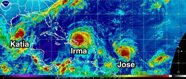
Katia is a category one hurricane and will drift into the coast of Mexico, well south of Brownsville, Texas late this week.
Jose will stay over the open Atlantic for the next seven days; it remains to be seen if it moves out to sea, or tries to bend back westward toward the U.S. Just too early to know.
IRMA STILL A CATEGORY FIVE: Maximum sustained winds are near 180 mph (285 km/h) with higher gusts. Irma is a category 5 hurricane on the Saffir-Simpson Hurricane Wind Scale. Some fluctuations in intensity are likely
during the next day or two, but Irma is forecast to remain a powerful category 4 or 5 hurricane during the next couple of days.
Irma is moving toward the west-northwest near 17 mph, and this general motion is expected to continue with some decrease in forward speed for the next couple of days. On the forecast track, the center should pass north of the coast of Hispaniola later today, be near the Turks and Caicos and southeastern Bahamas by this evening, and then be near the Central Bahamas by Friday.
A Hurricane Watch will likely be required later today for portions of southern Florida and the Florida Keys.
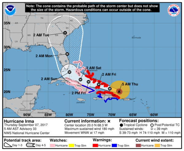
Irma will make a hard right turn north of Cuba, and is expected to be near Miami Sunday morning as a major, category four hurricane. From there, it moves northward near, or just off the Florida Atlantic coast Sunday and Sunday night, with a potential landfall near, or north of Savannah, GA Monday night.
Here are some notes on Hurricane Irma this morning…
*Don’t focus on the exact track since the average NHC track errors at days 3, 4, and 5 are about 120, 175, and 225 miles, respectively.
*Those on the Florida Atlantic coast (Miami, Fort Lauderdale, West Palm Beach, Daytona Beach, Jacksonville) need to continue preparations for a major hurricane, and heed evacuation orders from local officials.
*For the west coast of Florida (places like Naples, Fort Myers, Sarasota, St. Petersburg, and Tampa, lots of wind and rain are likely Sunday, but the most severe impact from Irma should be to the east.
*Concerning Orlando and Disney World, Sunday will be very wet and windy, but for now it looks like the highest impact will be a little east of there. The weather will improve greatly Monday.
*Those on the Georgia and South Carolina coasts need to prepare now for hurricane conditions expected Monday or Monday night of next week. For now, the NHC forecast has Irma as a category two at the time of landfall in this region, but remember the skill set in forecasting hurricane intensity is not especially high at 120 hours.
*Irma will have no direct impact on Alabama or the Central Gulf Coast (Gulf Shores, Pensacola, Navarre Beach, Destin, Panama City Beach).
BEACH FORECAST: Click here to see the AlabamaWx Beach Forecast Center page. The Beach Forecast is partially underwritten by the support of Brett/Robinson Vacation Rentals in Gulf Shores and Orange Beach. Click here to see Brett/Robinson’s Hot Deals now!
WEATHER BRAINS: Don’t forget you can listen to our weekly 90 minute netcast anytime on the web, or on iTunes. This is the show all about weather featuring many familiar voices, including our meteorologists here at ABC 33/40.
CONNECT: You can find me on all of the major social networks…
Facebook
Twitter
Google Plus
Instagram
Pinterest
Snapchat: spannwx
I will be doing a safety program this morning at ALAGASCO in Birmingham, and then I will be speaking at Capstone Village in Tuscaloosa. Look for the next Weather Xtreme video here by 4:00 this afternoon. Enjoy the day!
Category: Alabama's Weather, ALL POSTS, Weather Xtreme Videos
About the Author (Author Profile)
James Spann is one of the most recognized and trusted television meteorologists in the industry. He holds the AMS CCM designation and television seals from the AMS and NWA. He is a past winner of the Broadcast Meteorologist of the Year from both professional organizations.Subscribe
If you enjoyed this article, subscribe to receive more just like it.


