Warmer Days; Only Isolated Showers
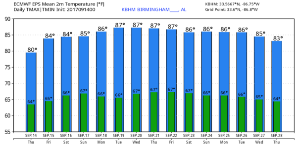
PATTERN CHANGE: The broad circulation over the eastern U.S… formerly known as Hurricane Irma, will be lifting out today, and an upper ridge will build across the region. This means an end of the unseasonably cooler weather of late. In Birmingham we established new record low maximum temperatures Monday and Tuesday, and tied the “record low high” yesterday with a high of 68. Keep in mind it can be very hot in September; for example today’s record high is 98, set in 1980. Today’s average high is 86.
Today will be partly sunny with a high in the low 80s this afternoon; the chance of any one spot seeing a shower today is so small that we have left it out of the forecast.
TOMORROW THROUGH SUNDAY: Very warm, and mostly dry. Partly to mostly sunny days, fair nights, and highs in the mid 80s tomorrow, and upper 80s over the weekend. A few spots could touch 90 degrees Saturday or Sunday afternoon. And, we will mention “widely scattered, mostly afternoon and evening showers and thunderstorms” on each day…. the chance of any one spot getting wet will be about one in five.
FOOTBALL WEATHER: Looking good for high school games tomorrow night; a small risk of an evening shower, otherwise mostly fair with temperatures falling from near 79 at kickoff into the low 70s by the fourth quarter.
Auburn hosts Mercer Saturday afternoon (3:00p CT kickoff)… we project a partly sunny sky with an outside risk of a shower or thunderstorm during the game. Temperatures near 87 at kickoff, falling into the upper 70s by the final whistle.
UAB also has an afternoon game; they host Coastal Carolina (12:00 noon CT kickoff) at Birmingham’s Legion Field. Temperature near 83 at kickoff, rising to near 88 by the fourth quarter. Partly sunny, a brief shower or thunderstorm is possible, but not likely.
And, Alabama hosts the Colorado State Rams at Bryant Denny Stadium Saturday evening (6:00p CT kickoff)… an outside chance of a brief shower or storm during the evening, otherwise mostly fair with temperatures falling from the mid 80s at kickoff into the 70s by the second half.
NEXT WEEK: The general pattern holds. Upper trough in the western states (where snow is likely some days across the northern Rockies), and an eastern trough for the east. Partly sunny, warm days, fair nights, and only isolated afternoon and evening showers and thunderstorms. Highs well up in the 80s, and again some spots could touch 90 degrees on a day or two. See the Weather Xtreme video for maps, graphics, and more details.
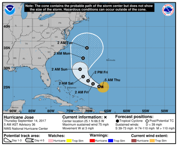
TROPICS: Hurricane Jose is packing sustained winds of 75 mph, well east of the Bahamas. It is projected to recurve off the U.S. East Coast over the next five days…
We are also watching two tropical waves in the eastern Atlantic moving westward; the lead wave has a medium chance of developing over the next five days. Too early to know if they will be a threat to land. We will keep an eye on them.
BEACH FORECAST: Click here to see the AlabamaWx Beach Forecast Center page. The Beach Forecast is partially underwritten by the support of Brett/Robinson Vacation Rentals in Gulf Shores and Orange Beach. Click here to see Brett/Robinson’s Hot Deals now!
WEATHER BRAINS: Don’t forget you can listen to our weekly 90 minute netcast anytime on the web, or on iTunes. This is the show all about weather featuring many familiar voices, including our meteorologists here at ABC 33/40.
CONNECT: You can find me on all of the major social networks…
Facebook
Twitter
Google Plus
Instagram
Pinterest
Snapchat: spannwx
I am doing a weather program this morning at Taylorville Primary School… look for the next Weather Xtreme video here by 4:00 this afternoon. Enjoy the day!
Category: Alabama's Weather, ALL POSTS, Weather Xtreme Videos
About the Author (Author Profile)
James Spann is one of the most recognized and trusted television meteorologists in the industry. He holds the AMS CCM designation and television seals from the AMS and NWA. He is a past winner of the Broadcast Meteorologist of the Year from both professional organizations.Subscribe
If you enjoyed this article, subscribe to receive more just like it.


