Dry Through Weekend; Tropical Trouble This Weekend?
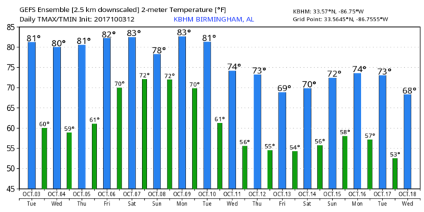
DRY THROUGH FRIDAY: Today is the 14th consecutive day without measurable rain for Birmingham, and the dry spell continues through Friday with mostly sunny warm days and fair pleasant nights. Highs will be in the 82-85 degree range, with lows between 58 and 62 for most places as an upper ridge holds over the eastern third of the nation.
And, we note as we enjoy quiet, warm weather, the western half of the U.S. is cold and unsettled; Havre, Montana has received over two feet of snow over the past 24 hours.
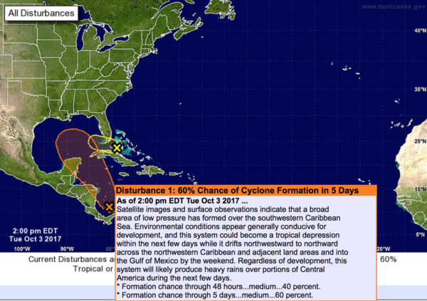
EYES ON THE GULF: Confidence is now high in the idea of a tropical depression or storm forming in the Gulf of Mexico by Friday. This system will lift either to the north or northeast, and will move into the Gulf Coast over the weekend. Beyond that, there is simply no way to give you any more specifics.
The disturbance, 90L, is now over the Southwest Caribbean, off the coast of Central America. Until it gets better organized, and we get better data from hurricane hunters later this week, models will struggle. The American global model, the GFS, shows landfall Sunday morning southwest of New Orleans on the Louisiana Coast. On the other hand, the more reliable European model (ECMWF) shows landfall Sunday evening close to Panama City Beach.
Some important points…
*If you have a beach vacation planned this weekend, I would not cancel yet. Simply too early to know the final outcome of the tropical situation, but you do need to be aware that a tropical storm could form and be a high impact event for some part of the Central Gulf Coast.
*The amount of rain in Alabama will all depend on the track of the tropical low. If the Euro solution is correct (landfall near Panama City Beach, with a movement into Georgia), when we will be on the “dry side” of the system with some rain certainly possible on Sunday and Monday, but the heavier totals will be east of our state. On the other hand, if the GFS is right, then, Alabama will get a good wet down Saturday and Sunday.
*The name of the system, if it becomes a tropical storm, will be “Nate”.
Just keep an eye on the blog for updates as the weekend gets closer.
NEXT WEEK: After the passage of the tropical system, the rest of next week looks fairly quiet with potential for a cooling trend.
BEACH FORECAST: Click here to see the AlabamaWx Beach Forecast Center page. The Beach Forecast is partially underwritten by the support of Brett/Robinson Vacation Rentals in Gulf Shores and Orange Beach. Click here to see Brett/Robinson’s Hot Deals now!
WEATHER BRAINS: Don’t forget you can listen to our weekly 90 minute netcast anytime on the web, or on iTunes. This is the show all about weather featuring many familiar voices, including our meteorologists here at ABC 33/40.
CONNECT: You can find me on all of the major social networks…
Facebook
Twitter
Google Plus
Instagram
Pinterest
Snapchat: spannwx
I had a great time today visiting with the kids at Blountsville Elementary… be watching for them on the Pepsi KIDCAM today at 5:00 on ABC 33/40 News! The next Weather Xtreme video will be posted here by 7:00 a.m. tomorrow…
Category: Alabama's Weather, ALL POSTS, Weather Xtreme Videos
About the Author (Author Profile)
James Spann is one of the most recognized and trusted television meteorologists in the industry. He holds the AMS CCM designation and television seals from the AMS and NWA. He is a past winner of the Broadcast Meteorologist of the Year from both professional organizations.Subscribe
If you enjoyed this article, subscribe to receive more just like it.


