

Dry, Mild Today… Showers Return Tomorrow
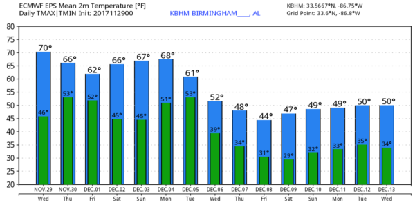
MILD AFTERNOON: Temperatures are above freezing this morning across Alabama, and project a high in the 67-70 degree range this afternoon. Mid and high level clouds will slowly increase thanks to a short wave approaching from the west, but the low levels will stay dry and we expect no rain today. Clouds will thicken tonight ahead of an approaching cold front.
SHOWERS RETURN TOMORROW: The day tomorrow will be mostly cloudy with a high in the 60s, and a few passing rain showers are likely. Nothing too heavy or widespread, but no doubt it should rain at least a time or two during the day. Not expecting much thunder if any at all, and rain amounts should be generally less than 1/2 inch.
FRIDAY THROUGH THE WEEKEND: The weather will be dry with partly sunny, mild days and fair cool nights. Highs mostly in the 60s, lows mostly in the 40s.
FOOTBALL WEATHER: For the high school playoff games Friday evening, the sky will be mostly fair with temperatures falling through the 50s.
For Auburn fans headed to Atlanta and the SEC Championship game Saturday against Georgia (3p CT kickoff)… no weather worries, of course, inside Mercedes-Benz Stadium, but for those walking to the game the sky will be mostly cloudy with just a small chance of a shower; afternoon temperatures should be in the 60s.
Jacksonville State hosts the Kennesaw State Owls Saturday at Burgess–Snow Field (1p CT kickoff)… the sky will be partly sunny with temperatures in the 60s during the game.
NEXT WEEK: Getting some good model agreement now as a big pattern change evolves. A cold front will bring a band of showers and thunderstorms to Alabama on Tuesday. Strong storms could be involved, but for now it doesn’t look like a major severe weather setup. Then, a deep upper trough settles into the eastern half of the U.S., and should bring down the coldest air so far this season into the state Wednesday through Friday with highs mostly in the 40s and lows in the 20s.
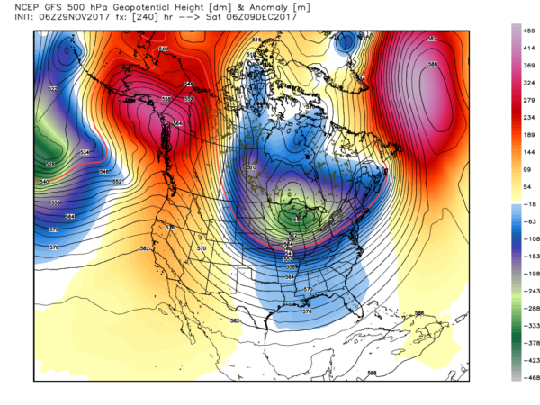
REST OF DECEMBER: The pattern looks generally cold and somewhat unsettled through mid-December, and possibly for the rest of the month as a blocked upper air pattern keeps a mean upper trough over the eastern third of the nation. We note global models suggests a negative AO (Arctic Oscillation) and NAO (North Atlantic Oscillation), which generally favors this setup.
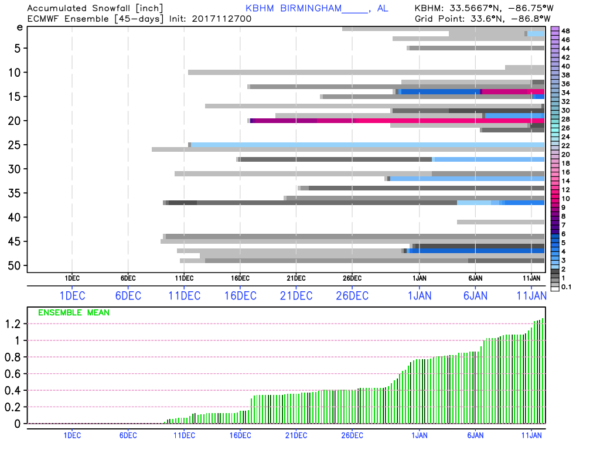
And, we need to mention the fact this brings out the “keyboard meteorologists” who love to post voodoo snow storms that show up on deterministic model output in the 10-15 day time frame. Long time readers know this is no way of forecasting the weather, and most of those “voodoo snow storms” never show up. But, it is the best way of getting clicks, shares, and likes. Please caution your friends to “think before they share” insane weather posts on social media.
Blog readers understand the limitations. For fun, below is output from the European global model ensemble (EPS), showing potential snow accumulation out to 45 days for Birmingham. Note that a little over half of the 51 members of the ensemble do show some chance of accumulating snow along the way, but that means, of course, the other half of the members show nothing at all. The ensemble mean is at 1.2″ of snow (cumulative) through January 11. This simple means a cold, unsettled pattern is ahead, you cannot read anything else beyond that into it.
BEACH FORECAST: Click here to see the AlabamaWx Beach Forecast Center page. The Beach Forecast is partially underwritten by the support of Brett/Robinson Vacation Rentals in Gulf Shores and Orange Beach. Click here to see Brett/Robinson’s Hot Deals now!
WEATHER BRAINS: Don’t forget you can listen to our weekly 90 minute netcast anytime on the web, or on iTunes. This is the show all about weather featuring many familiar voices, including our meteorologists here at ABC 33/40.
CONNECT: You can find me on all of the major social networks…
Facebook
Twitter
Google Plus
Instagram
Pinterest
Snapchat: spannwx
I have a weather program this morning at University Place Elementary in Tuscaloosa… look for the next Weather Xtreme video here by 4:00 this afternoon. Enjoy the day!
Category: Alabama's Weather, ALL POSTS, Weather Xtreme Videos
About the Author (Author Profile)
James Spann is one of the most recognized and trusted television meteorologists in the industry. He holds the AMS CCM designation and television seals from the AMS and NWA. He is a past winner of the Broadcast Meteorologist of the Year from both professional organizations.Subscribe
If you enjoyed this article, subscribe to receive more just like it.


