Rain Moves In; Much Colder Later Today
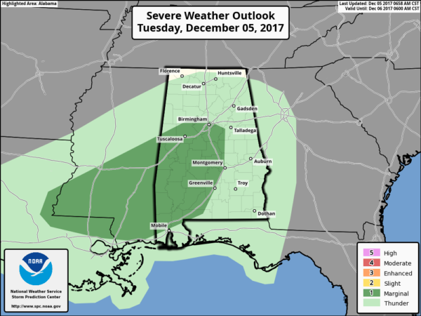
RADAR CHECK: Rain is increasing over the northern half of Alabama this morning ahead of a strong cold front near Memphis. SPC has introduced a “marginal risk” of severe storms for parts of Alabama. In their discussion… “While overly organized or consequential severe thunderstorms do not seem likely, a low-end risk for damaging wind gusts and/or a brief tornado may exist (perhaps with an absence of lightning).”
We will keep an eye on radar trends. Rain amounts of 1/2 to 1 inch can be expected through early tonight, when the rain shifts to the south.
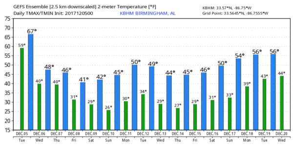
Temperatures will hover in the low 60s this morning, but they will fall sharply as the front passes. Northwest Alabama will drop into the 40s by mid to late morning, and places like Tuscaloosa, Birmingham, Anniston, and Gadsden will fall into the 40s by mid to late afternoon. Bottom line is that it feels pretty comfortable going into work this morning, but it will be raw and cold when you head home later today.
TOMORROW/THURSDAY: A pattern develops where moist air rides up and over the cold air near the surface; this means cloudy, cold weather on these two days with rain at times. Light rain is likely a decent part of the day tomorrow with a high only in the 40-44 degree range. Rain will be more scattered in nature Thursday; the high will be in the 44-48 degree range. These temperatures are 10-15 degrees below average for early December.
FRIDAY: The reliable European global models suggests that thermal profiles will be cold enough for some snow to mix in with the rain over parts of East-Central Alabama during the morning hours, and we will add that to our forecast.
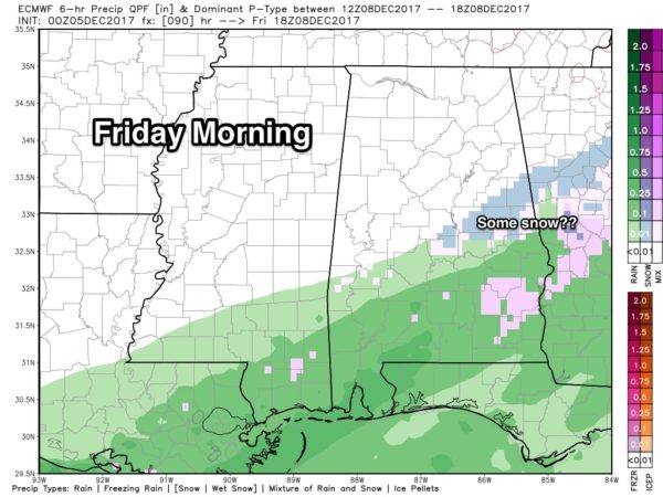
Places like Rockford, Alexander City, Dadeville, Lafayette, and Roanoke could see some snow flakes Friday morning, but temperatures will be above freezing (in the mid to upper 30s), and at this point we expect no impact. Otherwise, Friday will be cold and generally dry over the northern half of the state with a high in the 40s. Best chance of seeing a decent amount of sun will be over the Tennessee Valley of far North Alabama.
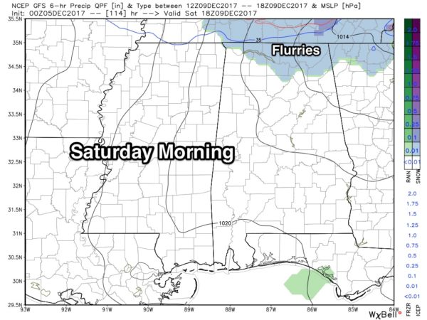
SATURDAY: The day will be cold and breezy; many North Alabama communities will have a hard time getting out of the 30s. And, a clipper type system moving down the back side of the upper trough over the eastern third of the nation will have potential to squeeze out snow flurries, or perhaps a few snow showers over the northern third of the state. Moisture will be limited, and for now we don’t expect any signifiant accumulation or impact. Best chance of seeing a few snow flakes Saturday morning will be along and north of U.S. 278, or north of a line from Hamilton to Cullman to Gadsden.
SUNDAY: Sunday morning will bring our coldest temperatures so far this season; most places will wind up somewhere between 18 and 22 degrees with a clear sky and light wind. The day Sunday will be mostly sunny and cold with a high in the 40s.
FOOTBALL WEATHER: The “Super 7” AHSAA football championship games will be played at Bryant-Denny Stadium in Tuscaloosa tomorrow through Friday. It will be cold, and some light rain is possible at times, especially tomorrow and Thursday. Daytime temperatures in the 40s, 30s at night.
NEXT WEEK AND BEYOND: The pattern continues to favor below average temperatures for at least the next 15 days; for now most of next week looks dry. See the Weather Xtreme video for maps, graphics, and more details.
BEACH FORECAST: Click here to see the AlabamaWx Beach Forecast Center page. The Beach Forecast is partially underwritten by the support of Brett/Robinson Vacation Rentals in Gulf Shores and Orange Beach. Click here to see Brett/Robinson’s Hot Deals now!
WEATHER BRAINS: Don’t forget you can listen to our weekly 90 minute netcast anytime on the web, or on iTunes. This is the show all about weather featuring many familiar voices, including our meteorologists here at ABC 33/40.
CONNECT: You can find me on all of the major social networks…
Facebook
Twitter
Google Plus
Instagram
Pinterest
Snapchat: spannwx
I have a weather program this morning at Southside Elementary in Gadsden… look for the next Weather Xtreme video here by 4:00 this afternoon. Enjoy the day!
Category: Alabama's Weather, ALL POSTS, Weather Xtreme Videos
About the Author (Author Profile)
James Spann is one of the most recognized and trusted television meteorologists in the industry. He holds the AMS CCM designation and television seals from the AMS and NWA. He is a past winner of the Broadcast Meteorologist of the Year from both professional organizations.Subscribe
If you enjoyed this article, subscribe to receive more just like it.


