Near 70 Tomorrow; Arctic Blast For The Weekend
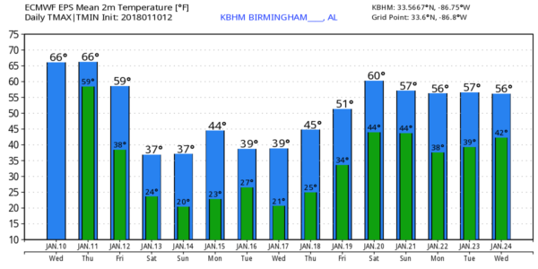
ONE MORE MILD DAY: Temperatures are mostly in the 60s across the great state of Alabama this afternoon; the sky is mostly cloudy and showers are few and far between. Tomorrow will be another mostly cloudy and very mild day; the high will be in the 67-70 degree range and we will mention the chance of a few passing showers. Some thunder is possible tomorrow night as a cold front approaches, but there is no risk of severe storms.
COLD AIR RETURNS FRIDAY: Rain will be widespread across Alabama Friday, and temperatures will fall through the day. We will be in the 50s during the early morning hours, in the 40s by midday, and into the 30s by mid to late afternoon. As colder air invades our state, rain will change over to a “wintry mix” of sleet, freezing rain, and snow over the Tennessee Valley of extreme North Alabama.
*The change over to sleet, snow, and freezing rain begins around Muscle Shoals and the northwest corner of the state by mid-morning Friday; the transition line will work steadily eastward during the day.
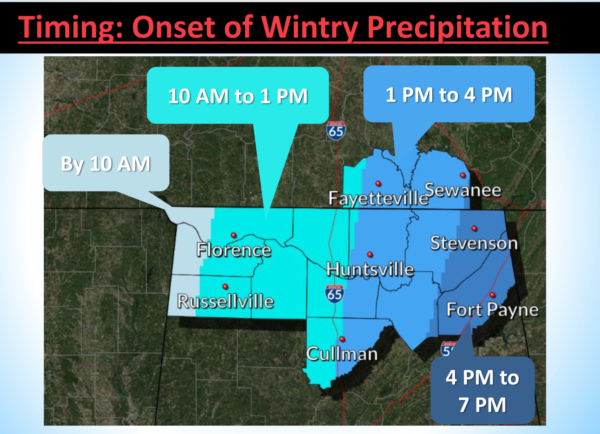
*The greatest chance of accumulating snow will be along and north of the Tennessee River; places like Florence, Athens, and Huntsville could see around one inch of snow; heavier totals will be to the north over Tennessee where a winter storm watch has been issued in general area west of I-65. Snow amounts over the western half of Tennessee will be in the 1-3″ range.
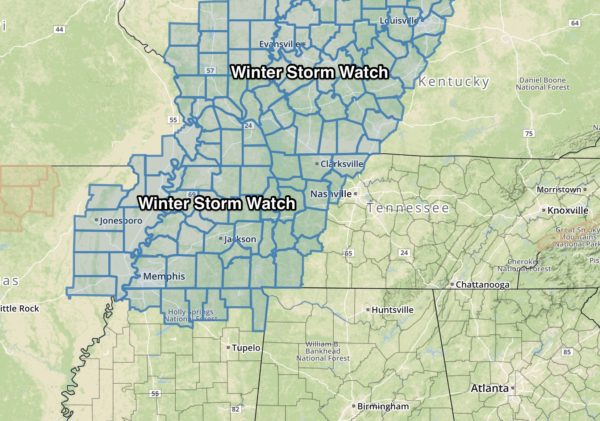
*At this time, no part of Alabama is in a winter storm watch, but a winter weather advisory could be required over the far northern part of the state later. Temperatures will fall below freezing Friday afternoon across the northern counties, and some icy travel is possible. Main impact will be across the far northern tier of counties in Alabama and north into Tennessee and Kentucky.
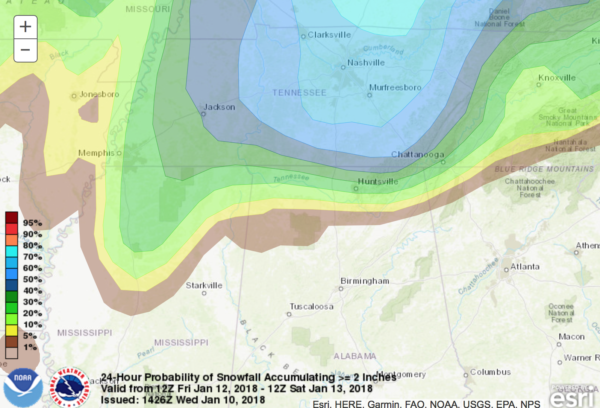
*For those interested in East Tennessee, including Knoxville, Pigeon Forge, and Gatlinburg, some light snow is possible Friday night and Saturday morning, but amounts should be fairly light, generally under 1 inch.
*At this point accumulation of wintry precipitation seems very unlikely for Birmingham, Tuscaloosa, Anniston, and Gadsden.
FRIGID WEEKEND: The weekend will be dry but very cold. Partly sunny Saturday with a high in the upper 30s, then we drop into the upper teens by daybreak Sunday. During the day Sunday the sky will be sunny with a high near in the 37-40 degree range.
NEXT WEEK: The first half of the week looks cold and dry; a reinforcing shot of cold air arrives Tuesday in the wake of a clipper. We warm up late in the week with some risk of showers around Friday January 19 or Saturday January 20. See the Weather Xtreme video for maps, graphics, and more details.
BEACH FORECAST: Click here to see the AlabamaWx Beach Forecast Center page. The Beach Forecast is partially underwritten by the support of Brett/Robinson Vacation Rentals in Gulf Shores and Orange Beach. Click here to see Brett/Robinson’s Hot Deals now!
WEATHER BRAINS: Don’t forget you can listen to our weekly 90 minute netcast anytime on the web, or on iTunes. This is the show all about weather featuring many familiar voices, including our meteorologists here at ABC 33/40.
CONNECT: You can find me on all of the major social networks…
Facebook
Twitter
Google Plus
Instagram
Pinterest
Snapchat: spannwx
Look for the next Weather Xtreme video here by 7:00 a.m. tomorrow…
Category: Alabama's Weather, ALL POSTS, Weather Xtreme Videos
About the Author (Author Profile)
James Spann is one of the most recognized and trusted television meteorologists in the industry. He holds the AMS CCM designation and television seals from the AMS and NWA. He is a past winner of the Broadcast Meteorologist of the Year from both professional organizations.Subscribe
If you enjoyed this article, subscribe to receive more just like it.


