

Clouds Move In Tonight; Rain By Tomorrow Evening
SUNNY, COOL FEBRUARY DAY: With sunshine in full supply, temperatures are generally in the upper 40s and low 50s across North/Central Alabama this afternoon; it is colder up over the Tennessee Valley of far North Alabama where some places are struggling to get out of the 30s.
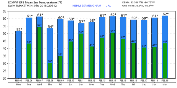
RAIN RETURNS: Clouds move into the state tonight, and they should keep temperatures above freezing. Tomorrow will be a cloudy but comfortable day; many places will see low 60s by afternoon. Showers are possible during the afternoon hours, but the rain becomes more widespread tomorrow night and Wednesday ahead of a slow moving front. This looks like another good soaking for the state, with amounts of 1-2 inches likely. We can’t rule out a strong storm at some point, but the instability looks very limited, and wind fields are not impressive. SPC, for now, has not outlooked any severe storms for Wednesday. Rain will end from west to east Wednesday evening.
THURSDAY/FRIDAY: These two days will be dry with a partly to mostly sunny sky; the high Thursday will be in the mid 50s, followed by mid 60s Friday. Clouds thicken Friday night ahead of the next wave approaching from the west.
WET WEEKEND: Saturday will be a mostly cloudy, mild day with developing rain showers by afternoon. Rain and a few thunderstorms are likely Saturday night into Sunday, and again we expect beneficial rain amounts; totals of 1 to 2″ are a good bet. We will keep an eye on future model runs, but at the moment it doesn’t look like a severe weather setup for Alabama. The high Saturday and Sunday will be in the 60s.
NEXT WEEK: Monday and Tuesday will trend drier, although global models now hint there could be enough moisture around for a few scattered showers. The week will feature pleasant temperatures, with highs in the 60s on several days. See the Weather Xtreme video for maps, graphics, and more details.
ON THIS DATE IN 2008: The “Super Tuesday” tornado outbreak… a total of 87 tornadoes occurred over the course of the outbreak, which lasted over 15 hours from the afternoon of February 5 until the early morning of February 6. The storm system produced several destructive tornadoes in heavily populated areas, most notably in the Memphis metropolitan area, in Jackson, Tennessee, and the northeastern end of the Nashville metropolitan area. In Alabama, an EF-4 tornado moved through parts of Lawrence and Morgan counties, killing three people near Moulton during the pre-dawn hours of February 6. Another EF-4 moved through the Rosalie and Pisgah communities, killing one person there.
BEACH FORECAST: Click here to see the AlabamaWx Beach Forecast Center page.
WEATHER BRAINS: Don’t forget you can listen to our weekly 90 minute netcast anytime on the web, or on iTunes. This is the show all about weather featuring many familiar voices, including our meteorologists here at ABC 33/40. We will produce this week’s show tonight at 8:30 CT… you can watch it live here.
CONNECT: You can find me on all of the major social networks…
Facebook
Twitter
Google Plus
Instagram
Pinterest
Snapchat: spannwx
I had a great time today visiting with the students at Advent Episcopal School in Birmingham… be looking for them on the Pepsi KIDCAM today at 5:00 on ABC 33/40 News! The next Weather Xtreme video will be posted here by 7:00 a.m. tomorrow…
Category: Alabama's Weather, ALL POSTS, Weather Xtreme Videos
About the Author (Author Profile)
James Spann is one of the most recognized and trusted television meteorologists in the industry. He holds the AMS CCM designation and television seals from the AMS and NWA. He is a past winner of the Broadcast Meteorologist of the Year from both professional organizations.Subscribe
If you enjoyed this article, subscribe to receive more just like it.


