Record Warmth Continues Through Friday
RECORD BREAKING WEEK: These new daily record highs were established across Alabama yesterday…
Birmingham 78 (old record was 76 in 2011, 1986, and 1971)
Anniston 78 (old record was 76 in 2011 and 1971)
Huntsville 77 (old record was 75 in 1939)
Montgomery soared to 82, missing the record high by one degree (83 set in 1891). Mobile’s high was 80, missing the record by three degrees.
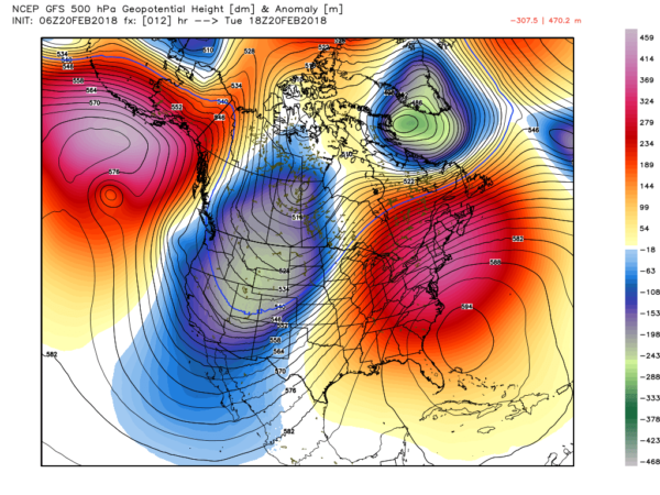
We will have potential for new daily record highs every day this week as a strong upper ridge continues to dominate the eastern third of the continental U.S.
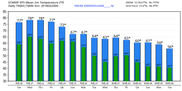
TODAY: We will forecast a mix of sun and clouds today with a high very close to 80 degrees; a few showers could pop up during the afternoon warmth, but they should be pretty isolated. The main band of organized showers and storms will remain west of Alabama, where flooding issues are possible from East Texas to the Great Lakes, along a very sharp cold front. The western and northern U.S. remain very cold, and in some places, very snowy under a deep upper trough.
TOMORROW THROUGH FRIDAY: Moisture will deepen a bit tomorrow and Thursday; we will mention some risk of scattered showers and storm both days over the northern half of the state. The most widespread rain coverage will be over the Tennessee Valley of far North Alabama, closed to a surface front that will stall over Tennessee tomorrow. Highs will be in the 77-81 degree range both days. Then, on Friday, the front moves northward as a warm front, and the ridge strengthens a bit, setting the stage for a very warm, dry day with a high in the low 80s. For now we are forecasting a high of 82 in Birmingham Friday; that is within one degree of the all time record for February, 83 set on Feb 8, 1918… Feb 13, 1962… and Feb 23, 1996.
THE ALABAMA WEEKEND: Not much change Saturday; it will be a partly sunny, warm day with a few scattered afternoon showers or storms possible; the high will be close to 80. Showers and storms become more likely Saturday night into Sunday morning, however, as another cold front approaches. SPC maintains a risk of severe storms over the northwest corner of Alabama Saturday night, but the threat for the rest of the state for now looks low. Sunday will be cooler with rain ending during the morning, most likely. The high will be back in the mid mid 60s.
NEXT WEEK: The front will stall out over the state, and we will need to bring in a chance of rain on a daily basis for at least the first half of the week; highs next week should be mostly in the 60s. See the Weather Xtreme video for maps, graphics, and more details.
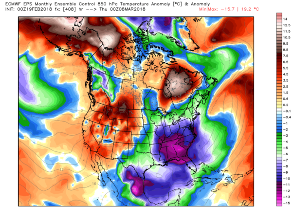
MARCH: With the Arctic Oscillation and the North Atlantic Oscillation headed into negative territory (based on global model guidance), it certainly opens for door for sharp cold snaps as we get into March. And, in turn, brings up the potential for active thunderstorm days. Winter isn’t over.
BEACH FORECAST: Click here to see the AlabamaWx Beach Forecast Center page.
WEATHER BRAINS: Don’t forget you can listen to our weekly 90 minute netcast anytime on the web, or on iTunes. This is the show all about weather featuring many familiar voices, including our meteorologists here at ABC 33/40.
CONNECT: You can find me on all of the major social networks…
Facebook
Twitter
Google Plus
Instagram
Pinterest
Snapchat: spannwx
I have a weather program this morning at Walter Kennedy Elementary School in Pell City… look for the next Weather Xtreme video here by 4:00 this afternoon. Enjoy the day!
Category: Alabama's Weather, ALL POSTS, Weather Xtreme Videos
About the Author (Author Profile)
James Spann is one of the most recognized and trusted television meteorologists in the industry. He holds the AMS CCM designation and television seals from the AMS and NWA. He is a past winner of the Broadcast Meteorologist of the Year from both professional organizations.Subscribe
If you enjoyed this article, subscribe to receive more just like it.


