Cold Front Over Far Northwest Alabama
ON THE MAP: The cold front, representing the leading edge of very cold air over the western two-thirds of the nation, has actually slipped into the northwest corner of Alabama. Muscle Shoals has dropped into the upper 60s, but the rest of the state remains at record warmth with temperatures near 80.
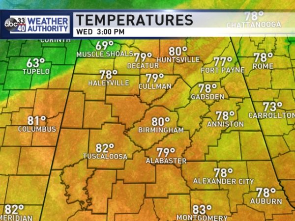
Birmingham’s high so far today is 81, beating the old record for February 21 of 78 set in 1922. Tuscaloosa has warmed to 82 degrees at 3:00pm CT. We do note widely scattered showers on radar, much like a summer afternoon. These showers are moving to the north.
The main batch of rain and storms along the front is to the west over Louisiana, where flash flood watches and warnings are in effect. A tornado watch is also in effect for parts of Louisiana until 5pm CT.
TOMORROW/FRIDAY: The front will slowly slip back to the north, and we will continue to be influenced by the intense upper ridge over the U.S. East Coast. Expect a mix of sun and clouds both days with highs around 80 degrees. Showers can’t be ruled out, but they will be widely spaced, like today.
THE ALABAMA WEEKEND: No real change during the day Saturday; the high will be 80 with a partly sunny sky. Any showers during the day will be pretty isolated. But, the cold front will get a good nudge to the south, and a band of showers and storms will move in here late Saturday night into Sunday morning. It looks like the main window for rain comes from about 12:00 midnight Saturday night through 12:00 noon Sunday; rain amounts will be in the 1/2 to 3/4″ range.
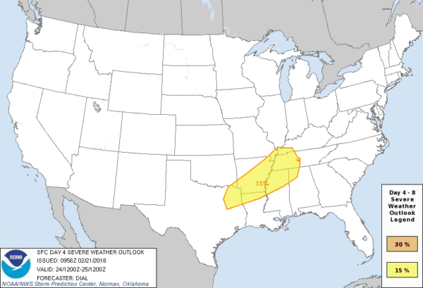
SPC has the northwest corner of the state in a severe weather risk for late Saturday night…
Storms could be strong to severe as they enter the state, but there is a decent chance they will weaken during the pre-dawn hours Sunday morning as the air becomes more stable and the upper support lifts away to the north. But, you always have to watch storms closely on fronts this time of the year.
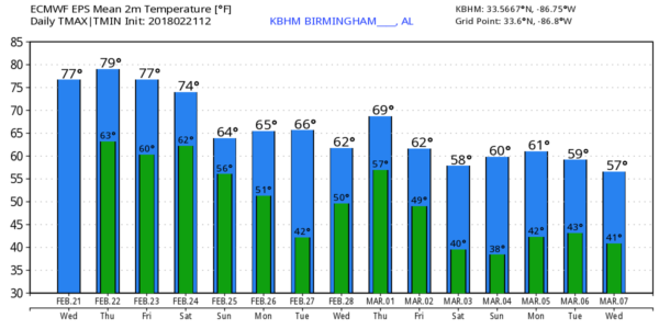
Sunday will be noticeably cooler with a high in the low 60s; communities north of Birmingham probably won’t get out of the 50s.
NEXT WEEK: The front will become stationary over Alabama Sunday night, and a wave of low pressure will bring rain at times Monday. It will be a cool rain for the northern half of the state; many places will hold in the 50s. Then, drier air slips in for a day on Tuesday, but moisture returns over the latter half of the week with some risk of showers daily Wednesday through Friday. Highs for the week will be mostly in the 60s.
LONG RANGE: Models are still advertising a negative Arctic Oscillation/North Atlantic Oscillation as we head into March, setting the stage for what should be some sharp cold snaps. Winter isn’t over, even though meteorological spring begins next week. See the Weather Xtreme video for maps, graphics, and more details.
ON THIS DATE IN 1971: The beginning of the “Mississippi Delta Tornado Outbreak”… a two day event that killed 123 people in three states. Entire communities in the state of Mississippi were “virtually leveled”. Three violent, long-lived tornadoes in western Mississippi and northeastern Louisiana caused most of the deaths along 300 miles of path. One of the tornadoes attained F5 intensity in Louisiana, the only such event on record in the state. Learn more on this blog post.
BEACH FORECAST: Click here to see the AlabamaWx Beach Forecast Center page.
WEATHER BRAINS: Don’t forget you can listen to our weekly 90 minute netcast anytime on the web, or on iTunes. This is the show all about weather featuring many familiar voices, including our meteorologists here at ABC 33/40.
CONNECT: You can find me on all of the major social networks…
Facebook
Twitter
Google Plus
Instagram
Pinterest
Snapchat: spannwx
I enjoyed seeing all of the students this morning at Ragland Elementary School… be looking for them on the Pepsi KIDCAM today at 5:00 on ABC 33/40 News! The next Weather Xtreme video will be posted here by 7:00 a.m. tomorrow…
Category: Alabama's Weather, ALL POSTS, Weather Xtreme Videos
About the Author (Author Profile)
James Spann is one of the most recognized and trusted television meteorologists in the industry. He holds the AMS CCM designation and television seals from the AMS and NWA. He is a past winner of the Broadcast Meteorologist of the Year from both professional organizations.Subscribe
If you enjoyed this article, subscribe to receive more just like it.


