Rain Returns Sunday Along With Cooler Air
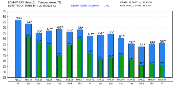
LATE WINTER WARMTH: Temperatures are close to 80 degrees across North/Central Alabama again this afternoon, but the persistent upper air pattern responsible for the warmth is beginning to break down, meaning some big weather changes over the weekend for Alabama.
TOMORROW: The day tomorrow should be warm and breezy, and while a few scattered showers are possible, most of the day will be dry. The high will be in the 76-80 degree range with more clouds than sun.
STORMS MOVE IN: The good news is that SPC continues to trim back the severe weather threat for Alabama late tomorrow night and early Sunday. Now, only the northwest corner of the state is in the “slight risk”… otherwise there is a “marginal risk” for the pre-dawn hours Sunday down to I-59 (Tuscaloosa/Birmingham/Gadsden).
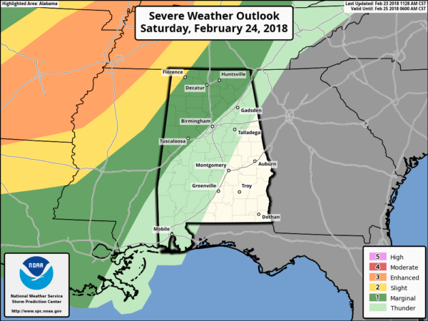
A band of strong storms will enter Northwest Alabama between midnight and 3:00 a.m. with potential for strong gusty winds and some small hail. The tornado threat is very low, but but zero. Those storms will weaken as the best upper support lifts away, and the air become more stable, and odds of severe storms in the Tuscaloosa/Birmingham/Anniston/Gadsden area early Sunday morning are fairly low. Still, we will watch radar trends closely since, when it comes to thunderstorms, you expect the unexpected.
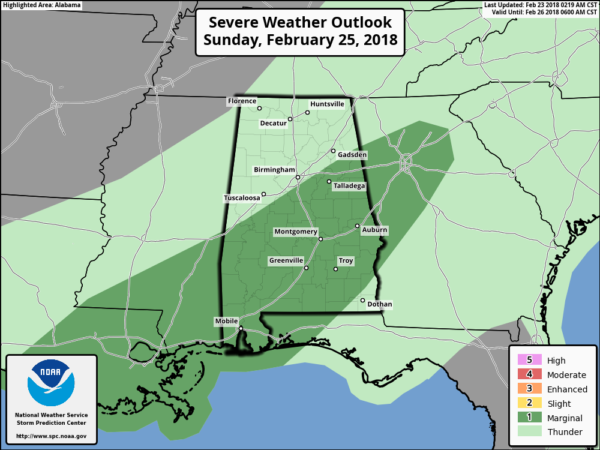
SUNDAY: The front will stall out over Central Alabama, and rain will continue much of the day over the northern half of the state in the cooler air. Communities north of Birmingham could hold in the 50s all day. Rain amounts of 1-2″ are likely between midnight tomorrow night and midnight Sunday night, and we will have to watch for flooding potential. And, south of the front, a few strong storms are possible Sunday afternoon over the southern half of the state, where SPC has a “marginal risk” in place.
NEXT WEEK: Showers will end Monday morning, and our weather looks dry Monday afternoon through Tuesday. Then, showers return Wednesday as a surface low develops west of the state, and a cold front pushes through early Thursday morning followed by sharply cooler air. See the Weather Xtreme video for maps, graphics, and more details.
BEACH FORECAST: Click here to see the AlabamaWx Beach Forecast Center page.
WEATHER BRAINS: Don’t forget you can listen to our weekly 90 minute netcast anytime on the web, or on iTunes. This is the show all about weather featuring many familiar voices, including our meteorologists here at ABC 33/40.
CONNECT: You can find me on all of the major social networks…
Facebook
Twitter
Google Plus
Instagram
Pinterest
Snapchat: spannwx
I had a great time today seeing the third graders at Trace Crossings Elementary in Hoover, and the kindergarten students at Cahaba Elementary in Trussville… be looking for them on the Pepsi KIDCAM today at 5:00 and 6:00 on ABC 33/40 News! My next Weather Xtreme video will be posted here Monday morning by 7:00… Brian Peters will have the video updates tomorrow and Sunday. Enjoy the weekend!
Category: Alabama's Weather, ALL POSTS, Weather Xtreme Videos
About the Author (Author Profile)
James Spann is one of the most recognized and trusted television meteorologists in the industry. He holds the AMS CCM designation and television seals from the AMS and NWA. He is a past winner of the Broadcast Meteorologist of the Year from both professional organizations.Subscribe
If you enjoyed this article, subscribe to receive more just like it.


