Drier Air Pushing Into Alabama
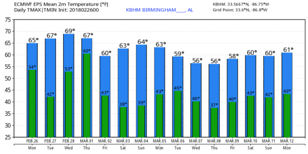
RADAR CHECK: Still raining over parts of East and South Alabama early this morning, but drier air is pushing into the northwest part of the state. The sky becomes partly sunny today with a high in the upper 60s for most communities. Tonight will be fair and cool; we drop into the 40-45 degree range early tomorrow morning.
SUNNY TUESDAY: Tomorrow will feature a good supply of sunshine; the high will be very close to 70 degrees. But, clouds return tomorrow night as the front down to the south begins to move northward as a warm front.
MORE RAIN: Wednesday will be a mostly cloudy day with occasional rain showers likely; we could see some thunderstorms involved by Wednesday night. We note SPC has a risk of severe weather defined just west of here… with a “marginal risk” clipping the northwest counties of our state…
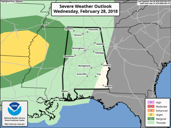
The weather stays mild Wednesday with a high near 70 degrees. A surface low will deepen northwest of Alabama, and by Thursday will be over Indiana with a trailing cold front. Will bring some risk of strong storms part of the day Thursday, but for now models show little surface based instability, and SPC does not have organized severe weather forecast on their “Day 4” outlook. Rain amounts Wednesday and Thursday should be between 1 and 2 inches for North/Central Alabama.
FRIDAY AND THE WEEKEND: Friday will be mostly sunny, but breezy and cool. We start the day in the mid 30s, followed by a high in the low 60s. Then, we will enjoy a dry weekend for a change with sunny pleasant days and clear chilly nights. Highs will be in the 65-70 degree range, with morning lows in the 30s. Some of the colder spots could see a light freeze early Saturday morning.
NEXT WEEK: Monday will be another dry day, but showers return Tuesday and Tuesday night with an approaching cold front. Cooler, drier air follows for the latter half of the week.
TIME TO PLANT: NO. Every year we advise waiting until April 15… the risk of freezing temperatures will remain high through then.
BEACH FORECAST: Click here to see the AlabamaWx Beach Forecast Center page.
WEATHER BRAINS: Don’t forget you can listen to our weekly 90 minute netcast anytime on the web, or on iTunes. This is the show all about weather featuring many familiar voices, including our meteorologists here at ABC 33/40. We will produce this week’s show tonight at 8:30 CT… you can watch it live here.
CONNECT: You can find me on all of the major social networks…
Facebook
Twitter
Google Plus
Instagram
Pinterest
Snapchat: spannwx
I have a weather program this morning at Woodland Forest Elementary in Tuscaloosa… look for the next Weather Xtreme video here by 4:00 this afternoon. Enjoy the day!
Category: Alabama's Weather, ALL POSTS, Weather Xtreme Videos
About the Author (Author Profile)
James Spann is one of the most recognized and trusted television meteorologists in the industry. He holds the AMS CCM designation and television seals from the AMS and NWA. He is a past winner of the Broadcast Meteorologist of the Year from both professional organizations.Subscribe
If you enjoyed this article, subscribe to receive more just like it.


