Storms End This Evening; Dry Days Ahead
RADAR CHECK: A strong upper wave is digging through Alabama this afternoon producing scattered showers and thunderstorms. Due to the cold air aloft, hail is falling from the heavier showers (mostly small hail). These showers and storms will dissipate once the sun goes down later this evening, and the wave moves on to the east.

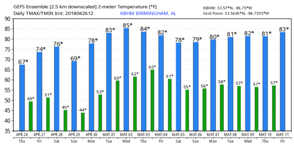
TOMORROW THROUGH THE WEEKEND: Dry, pleasant weather is the story. Tomorrow will be partly sunny with a high between 72 and 75… then we are forecasting sunshine in full supply over the weekend. The high Saturday will be in the mid 70s, but Sunday will be a tad cooler with a high closer to 70. No rain worries for a change.
RACE WEEKEND: For tomorrow at the Talladega Superspeedway the sky will be partly sunny day with a high close to 70 degrees. Then, the weather could not be any better for the weekend. Sunny Saturday and Sunday; highs in the mid 70s Saturday followed by a a maximum temperature close to 70 Sunday for the Geico 500.
MULLET TOSS: The annual event at the Flora-Bama draws huge crowds, and the weekend on the Gulf Coast will be spectacular. Sunny days, fair nights tomorrow through Sunday with highs in the 70s. Water temperatures in the Gulf are running in the mid 70s.
NEXT WEEK: A strong upper ridge will build over the eastern third of the nation, and that will bring the warmest weather so far this year to our state. The weather looks dry at least through Thursday; the high Monday will be in the upper 70s, followed by low 80s Tuesday and Wednesday, and mid 80s Thursday and Friday. You will be hearing of a severe weather threat for the Southern Plains next week, but models show the main energy weakening and passing well north of Alabama late in the week. It could bring a few showers and storms in here late Friday or Friday night (May 4), but for now it looks like we won’t have any severe weather issues in our state. See the Weather Xtreme video for maps, graphics, and more details.
ON THIS DATE SEVEN YEARS AGO: The second day of “superoutbreak” of tornadoes, which lasted from April 25-28, 2011. Numerous tornadoes touched down across several states, including Texas, Louisiana, Arkansas. Most of those tornadoes were weak, but a few of them caused considerable damage. A long-tracked wedge tornado caused EF2 damage in rural portions of Texas and Louisiana. An EF3 tornado destroyed multiple structures and caused severe damage at Fort Campbell, Kentucky as well. A total of 55 tornadoes were confirmed the 26th, although no fatalities occurred. The peak of the event, however, would come the next day, April 27.
BEACH FORECAST: Click here to see the AlabamaWx Beach Forecast Center page.
WEATHER BRAINS: Don’t forget you can listen to our weekly 90 minute netcast anytime on the web, or on iTunes. This is the show all about weather featuring many familiar voices, including our meteorologists here at ABC 33/40.
CONNECT: You can find me on all of the major social networks…
Facebook
Twitter
Google Plus
Instagram
Pinterest
Snapchat: spannwx
I enjoyed seeing the students today at Whitesboro Elementary in Etowah County… be looking for them on the Pepsi KIDCAM today at 5:00 on ABC 33/40 News! The next Weather Xtreme video will be posted here by 7:00 a.m. tomorrow…
Category: Alabama's Weather, ALL POSTS, Weather Xtreme Videos
About the Author (Author Profile)
James Spann is one of the most recognized and trusted television meteorologists in the industry. He holds the AMS CCM designation and television seals from the AMS and NWA. He is a past winner of the Broadcast Meteorologist of the Year from both professional organizations.Subscribe
If you enjoyed this article, subscribe to receive more just like it.


