Drier Air To Creep Into North Alabama Wednesday
RADAR CHECK: The weather is relatively quiet over North/Central Alabama this afternoon thanks to a batch of showers and storms that moved through earlier today. The morning convection left behind rain-cooled, stable air with temperatures in the 70s and 80s. We do note a few strong storms on radar at mid-afternoon over Pickens, Greene, and Sumter Counties in West Alabama…. they are drifting slowly to the south.

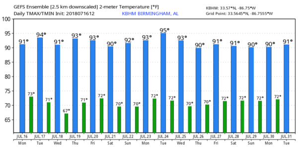
Tomorrow will be much like today; occasionally cloudy with scattered to numerous showers and thunderstorms as a surface front approaches from the north. The high will be in the 87-90 degree range.
WEDNESDAY THROUGH FRIDAY: The front is expected to reach Central Alabama by Wednesday morning, with drier air filtering into the northern half of the state. Accordingly, it looks like most of North/Central Alabama will be dry Wednesday and Thursday with only a small risk of a shower; we will maintain the chance of scattered showers and storms over South Alabama both days south of the front. Then, on Friday, a disturbance moving down the back side of an upper trough over the eastern third of the nation could bring a batch of showers and storms, but forecasting these “northwest flow” thunderstorms is a challenge. We project highs in the 90-93 degree range Wednesday through Friday.
THE ALABAMA WEEKEND: The latest model data suggests we will need to mention a chance of scattered showers and storms Saturday, but they should be fewer in number Sunday as the upper trough shifts to the east. Highs over the weekend will be in the 87-90 degree range.
NEXT WEEK: The week looks fairly quiet with a decent amount of sunshine each day, but we will still need to mention the risk of a few scattered showers and storms during the afternoon and evening hours… see the Weather Xtreme video for maps, graphics, and more details.
TROPICS: All is calm across the Atlantic basin and tropical storm formation is not expected through the week.
BEACH FORECAST: Click here to see the AlabamaWx Beach Forecast Center page.
WEATHER BRAINS: Don’t forget you can listen to our weekly 90 minute netcast anytime on the web, or on iTunes. This is the show all about weather featuring many familiar voices, including our meteorologists here at ABC 33/40. We will produce this week’s show tonight at 8:30… you can watch it live here.
CONNECT: You can find me on all of the major social networks…
Facebook
Twitter
Google Plus
Instagram
Pinterest
Snapchat: spannwx
I enjoyed seeing a nice group of children today at Mountain Brook Presbyterian Church… be looking for them on the Pepsi KIDCAM today at 5:00 on ABC 33/40 News! The next Weather Xtreme video will be posted here by 7:00 a.m. tomorrow…
Category: Alabama's Weather, ALL POSTS, Weather Xtreme Videos
About the Author (Author Profile)
James Spann is one of the most recognized and trusted television meteorologists in the industry. He holds the AMS CCM designation and television seals from the AMS and NWA. He is a past winner of the Broadcast Meteorologist of the Year from both professional organizations.Subscribe
If you enjoyed this article, subscribe to receive more just like it.


