Michael Headed For The Gulf Coast; Cool Air Later This Week
EYES ON THE GULF: Michael should become a hurricane today as it moves into the southern Gulf of Mexico; here in Alabama today will be warm again with a high in the 80s.. the sky will be partly to mostly sunny with only isolated showers this afternoon.
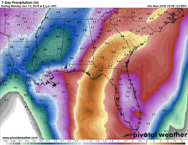
Clouds will increase a bit tomorrow, with a few scattered showers across the state as moisture levels rise; the high will be in the low 80s for most communities. Then, on Wednesday, showers are likely over the northern half of the state as Michael gets close to the Florida Gulf Coast. The heaviest rain from the tropical system will come over Southeast Alabama; rain amounts over North and West Alabama will be much lighter, generally under 1/2 inch.
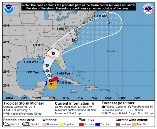
THE LATEST ON MICHAEL: Here is a detailed look at Michael this morning…
*Data from the Hurricane Hunter aircraft indicate that maximum sustained winds have increased to near 70 mph with higher gusts. Additional strengthening is forecast, and Michael is expected to become a hurricane later today. Michael is forecast to be near or at major hurricane strength when it reaches the northeastern Gulf of Mexico tomorrow night and Wednesday.
*A Hurricane Watch is in effect from the Alabama-Florida border to Suwanee River Florida
*A Tropical Storm Watch is in effect for the Alabama Gulf Coast, and from the Suwanee River to Anna Maria Island Florida, including Tampa Bay
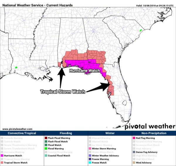
*A Storm Surge Watch is in effect from Navarre Florida to Anna Maria Island Florida, including Tampa Bay
*Michael is expected to make landfall on the Florida coast, somewhere between Destin and Apalachicola, Wednesday or Wednesday night. There is still some uncertainty in timing, landfall location, and intensity.
*Michael is forecast to be a hurricane, and possibly a major hurricane, when it reaches the Gulf Coast by mid-week, and storm surge and hurricane watches are now in effect for portions of the area. Some areas along the Florida Gulf Coast are especially vulnerable to storm surge, regardless of the storm’s exact track or intensity. Residents in the watch areas should monitor the progress of this system and follow any advice given by local officials.
*Dangerous rip currents are likely on the coast through Thursday; double red flags will be flying along many beaches as early as today.
*The highest impact, in terms of storm surge flooding, freshwater flooding, and wind will be along and to the right (east) of the point where Michael makes landfall.
*The Alabama Gulf Coast will be on the “good”, west side of the circulation with an offshore flow. This means no storm surge issues, and no flooding problems are expected there Wednesday and Wednesday night.
*Inland, the heaviest rain will come over North Florida, the southeast corner of Alabama, the southern half of Georgia, and across the Carolinas. Rain amounts will be light over much of Alabama, with the exception of those southeast counties around Dothan and Ozark.
*A few tornadoes are possible Wednesday and Wednesday night over North Florida and far South Georgia.
*Conditions will greatly improve on the Gulf Coast Thursday, and the weather will be beautiful there Friday through the weekend with sunny days, fair nights, and very comfortable temperatures. The weather looks perfect for the National Shrimp Festival in Gulf Shores Thursday through Sunday.
*Remember, changes are always possible, so keep an eye on the blog for forecast updates as Michael gets closer to the coast.
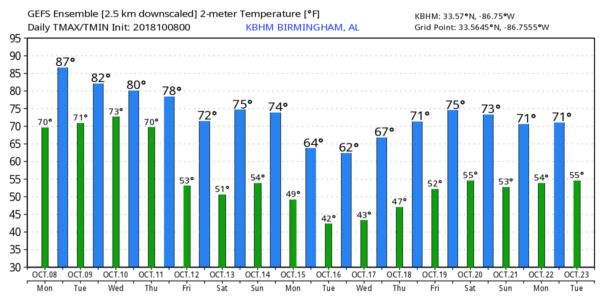
COOL CHANGE: As Michael moves quickly to the northeast, a refreshing, cool airmass will move into Alabama Thursday, and we are forecasting delightful fall weather through Saturday with sunny pleasant days and clear cool nights… highs in the 70s and lows in the 50s. Most of the day Sunday looks dry, although a few showers could show up late in the day and Sunday night with a cold front coming through. Moisture will be limited, and rain amounts will be light.
RACE WEEKEND: We are forecasting clearing at Talladega by Thursday afternoon, then expect sunshine in full supply Friday and Saturday with highs in the 70s. Most of the day Sunday will be dry; a few showers could reach East Alabama Sunday night after the race. The high Sunday will be in the upper 70s.
NEXT WEEK: Even cooler air blows into Alabama early in the week with highs dropping into the 60s, and lows in the 40s Monday and Tuesday… see the Weather Xtreme video for maps, graphics, and more details.
BEACH FORECAST: Click here to see the AlabamaWx Beach Forecast Center page.
WEATHER BRAINS: Don’t forget you can listen to our weekly 90 minute show anytime on your favorite podcast app. This is the show all about weather featuring many familiar voices, including our meteorologists here at ABC 33/40.
CONNECT: You can find me on all of the major social networks…
Facebook
Twitter
Instagram
Pinterest
Snapchat: spannwx
I have a weather program this morning at Pickens Academy in Carrollton… look for the next Weather Xtreme video here by 4:00 this afternoon. Enjoy the day!
Category: Alabama's Weather, ALL POSTS, Tropical, Weather Xtreme Videos
About the Author (Author Profile)
James Spann is one of the most recognized and trusted television meteorologists in the industry. He holds the AMS CCM designation and television seals from the AMS and NWA. He is a past winner of the Broadcast Meteorologist of the Year from both professional organizations.Subscribe
If you enjoyed this article, subscribe to receive more just like it.


