Michael Growing Stronger; Big Cool-Down For Alabama Late This Week
RADAR CHECK: As expected, showers are very isolated across the northern half of Alabama this afternoon; the sky is partly sunny and temperatures are in the 80s. Shower activity is a little more concentrated over the southern half of the state, south of U.S. 80.
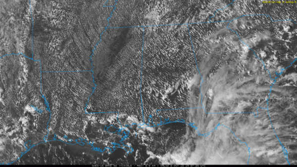
The weather won’t change much tomorrow, although high clouds will increase ahead of Hurricane Michael. Showers will remain pretty scattered in nature, and the high will be in the low 80s. Then, on Wednesday, a few periods of rain are likely, but amounts won’t be all that heavy, and it certainly won’t rain all day. The main swath of wind and rain associated with Michael will be well southeast of here; winds for North Alabama Wednesday should be 15 mph or lower, and rain amounts will be under 1/2 inch for most places.
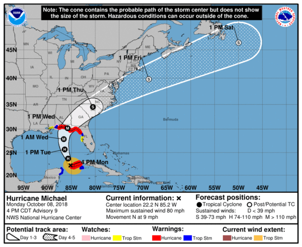
THE LATEST ON MICHAEL: Michael is a category one hurricane near the Yucatan Channel this afternoon; it is expected to strengthen over the next 24 hours, becoming a major, category three hurricane by tomorrow night in the Gulf of Mexico.
*A Hurricane Warning has been issued for the Gulf Coast of Florida from the Alabama/Florida border eastward to Suwannee River.
*A Tropical Storm Warning has been issued from the Alabama/Florida border westward to the Mississippi/Alabama border (this includes all of the Alabama Gulf Coast) and from Suwannee River Florida southward to Chassahowitzka Florida.
*A Storm Surge Warning has been issued for the Gulf Coast of Florida from the Okaloosa/Walton County Line to Anclote River.
*The updated NHC track has been nudged slightly westward through 48 hours to be closer to the latest consensus aids.
*Landfall is expected somewhere between Destin and Panama City Beach Wednesday, during the midday or early afternoon hours. Life-threatening storm surge is likely along portions of the coasts of the Florida Panhandle, Big Bend, and Nature Coast, and a storm surge warning is in effect for these areas. Residents in these areas should follow all advice given by their local officials.
*A hurricane warning has been issued for portions of the Florida Gulf Coast, and everyone in these areas should prepare for life-threatening winds associated with the core of Michael. Damaging winds will also extend inland across portions of the Florida Panhandle, southern Georgia, and southeast Alabama as Michael moves inland.
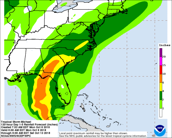
*Heavy rainfall from Michael could produce life-threatening flash flooding from the Florida Panhandle and Big Bend region into portions of Georgia and South Carolina.
*Dangerous rip currents are likely on the coast through Thursday; double red flags are flying now at many beaches.
*Weather conditions will begin to deteriorate on the Florida coast late tomorrow and tomorrow night, and hurricane conditions are likely Wednesday. The most severe impact will be along and east of where the center of the storm makes landfall. For now it looks like the greatest risk of wind damage, and storm surge and freshwater flooding will come in places like Mexico Beach, Port Saint Joe, Indian Pass, Apalachicola, St. George Island, Carrabelle, and around the “Big Bend” region of Florida.
*A few tornadoes are possible over parts of North and West Florida, and South Georgia late tomorrow night and Wednesday as Michael moves inland.
*The Alabama Gulf Coast, Pensacola, Navarre Beach will be on the “good” west side of the hurricane with an offshore flow. Still, Wednesday will be windy and wet in these places, but the weather won’t be especially dangerous. A tropical storm warning is in effect for these places, meaning winds could exceed 40 mph Wednesday.
*Michael will not stall like Florence, but it will still be capable of producing rain amounts of 6-10 inches in spots over North Florida and South Georgia. Heaviest rain in Alabama will come over the southeast corner of the state, around Dothan and Ozark, where 3-5 inches are possible.
*Sunshine returns to the Central Gulf Coast Thursday, and the weather looks delightful Thursday through the weekend with sunny pleasant days and fair nights. Perfect weather for the National Shrimp Festival in Gulf Shores.
*Remember, with any tropical system there is always a chance of a forecast change, so keep in touch with the latest forecasts here on the blog as Michael gets closer to the coast.
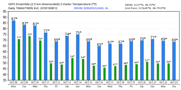
FRIDAY AND THE WEEKEND IN ALABAMA: As Michael moves rapidly northeast, it will help to pull much cooler air into the state. Friday and Saturday will be delightful with sunny pleasant days and clear cool nights; highs will be in the 70s and lows mostly in the 50s. Cooler pockets will see 40s early Friday and Saturday morning. We will need to mention some risk of showers Sunday afternoon and Sunday evening with a cold front; moisture will be limited and amounts should be fairly light.
RACE WEEKEND AT TALLADEGA: Sunny pleasant days, clear cool nights Friday and Saturday with highs in the 70s and lows in the 50s. We can’t totally rule out a shower around the Superspeedway Sunday afternoon, but for now it looks like the better chance will come after the race is complete. The high Sunday will be in the 70s.
NEXT WEEK: Even cooler air follows the Sunday night front; highs drop into the 60s, and lows in the 40s for the first half of the week. Colder pockets across North Alabama could visit the 30s Tuesday morning with some scattered frost possible for the first time this season. See the Weather Xtreme video for maps, graphics, and more details.
BEACH FORECAST: Click here to see the AlabamaWx Beach Forecast Center page.
WEATHER BRAINS: Don’t forget you can listen to our weekly 90 minute show anytime on your favorite podcast app. This is the show all about weather featuring many familiar voices, including our meteorologists here at ABC 33/40.
CONNECT: You can find me on all of the major social networks…
Facebook
Twitter
Instagram
Pinterest
Snapchat: spannwx
I had a great time today visiting with the students at Pickens Academy in Carrollton… be looking for them on the Pepsi KIDCAM today at 5:00 on ABC 33/40 News! The next Weather Xtreme video will be posted here by 7:00 a.m. tomorrow…
Category: Alabama's Weather, ALL POSTS, Tropical, Weather Xtreme Videos
About the Author (Author Profile)
James Spann is one of the most recognized and trusted television meteorologists in the industry. He holds the AMS CCM designation and television seals from the AMS and NWA. He is a past winner of the Broadcast Meteorologist of the Year from both professional organizations.Subscribe
If you enjoyed this article, subscribe to receive more just like it.


