Strong To Severe Storms Late Tonight/Early Tomorrow
THE STORMS OF NOVEMBER: We are now in the late fall severe weather season in Alabama… and we do have a threat of strong to severe thunderstorms over North Alabama late tonight into early tomorrow. But, before the storms arrive, today looks fairly quiet. The sky will feature more clouds than sun, but most of the day will be dry with a high around 70 degrees this afternoon.
Tonight, a potent weather system will impact the state. A deep upper trough with strong wind fields with a strengthening low level just will come into play, interacting with an unstable and highly sheared atmosphere.
SPC maintains an “enhanced risk” (level 3/5) for areas north of a line from Sulligent to Haleyville to Huntsville. The standard “slight risk” (level 2/5) extends as far south as York, Greensboro, Hoover, Glencoe, and Centre. And, a “marginal risk” (level 1/5) runs down to Jackson, Greenville, and Auburn.
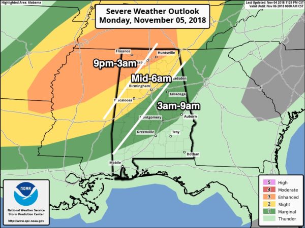
TIMING: Storms will enter Northwest Alabama after 9:00 p.m… then progressing southeastward through the state during the night. They should reach Tuscaloosa/Birmingham/Gadsden sometime after 3:00 a.m. The storms should be out of North/Central Alabama by 9:00 a.m. tomorrow, and the rest of Election Day will be dry for the northern half of the state; showers and storms will linger over South Alabama into the afternoon, but there is no risk of severe storms down there as the upper support lifts away.
THREATS: SPC suggests the highest tornado threat will be over North Mississippi tonight, but a few tornadoes are certainly possible over North Alabama as well, especially in the enhanced risk area over Northwest Alabama. The main tornado threat will come from any discrete cells that form ahead of the squall line; otherwise damaging winds are the main issue with the line as it passes across North Alabama late tonight. Some hail is possible, but not especially likely. We don’t expect any flooding issues.
CALL TO ACTION: You need to be able to hear severe weather warnings, know where you are going if you are in a tornado warning polygon, and have the right things in your safe place.
*Every Alabama home needs a NOAA Weather Radio, properly programmed, and with a good battery backup. You can find them at many local retail stores. And, you can program them… see this video from our meteorologist Charles Daniel for easy instructions.
*Your second way of getting a warning is your smart phone. Be sure WEA (Wireless Emergency Alerts”) notifications are enabled… go to “settings”, “notifications”, and at the bottom your will see the options for “government alerts”. This has NOTHING to do with politics; be sure “emergency alerts” is enabled to receive tornado and flash flood warnings. Also have a good app designed for warnings on your phone, like this one.
*Get the ABC 33/40 mobile app on your phone so you can continue to watch our live coverage in your safe place.
Get the iOS version (for iPhones/iPads) here.
*Know where are you going. Your safe place is a small room (bathroom, closet, hallway) on the lowest floor, away from windows, and near the center of the home or building. If you live in a mobile home, you have to leave if you are in a tornado warning polygon. Know the location of a shelter that is available 24 hours, and be ready to get there quickly. Remember, a good part of this severe weather event early next week will be in the middle of the night.
*In your safe place, have helmets (bicycle or batting helmets are great) for everyone in the family, NOT just the kids. Also, everyone needs a portable air horn (if you need help first responders can hear them), and hard sole shoes (if you have to walk over a tornado debris field to get help). Portable chargers for your cell phones are also important so you can stay in touch and watch our severe weather coverage.
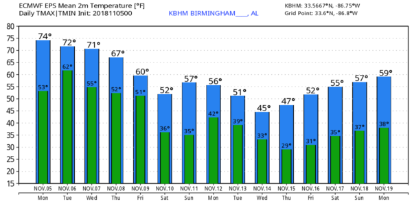
REST OF THE WEEK: The surface front will become stationary across far South Alabama… Wednesday and Thursday look like cloudy days with some rain at times; highs will be in the 60s. Colder air arrives Friday; we hold in the 50s most of the day with only an outside risk of a shower.
THE WEEKEND: The weekend will feature sunny cool days and clear cold nights. We project the coldest temperatures so far this season both Saturday and Sunday morning with lows in the 30-36 degree range. Colder pockets will see a freeze, most other North/Central Alabama communities will have frost. Afternoon highs will be near 60 degrees both days.
NEXT WEEK: The week looks mostly dry with temperatures well below average; Monday’s high will drop to near 50 degrees, and the northern half of the state should see a widespread freeze by Tuesday and Wednesday morning. Many places will visit the 20s for the first time this season… see the Weather Xtreme video for maps, graphics, and more details.
BEACH FORECAST: Click here to see the AlabamaWx Beach Forecast Center page.
WEATHER BRAINS: Don’t forget you can listen to our weekly 90 minute show anytime on your favorite podcast app. This is the show all about weather featuring many familiar voices, including our meteorologists here at ABC 33/40.
CONNECT: You can find me on all of the major social networks…
Facebook
Twitter
Instagram
Pinterest
Snapchat: spannwx
I have a weather program this morning at Eden Elementary School in Pell City… look for the next Weather Xtreme video here by 4:00 this afternoon. Enjoy the day!
Category: Alabama's Weather, ALL POSTS, Weather Xtreme Videos
About the Author (Author Profile)
James Spann is one of the most recognized and trusted television meteorologists in the industry. He holds the AMS CCM designation and television seals from the AMS and NWA. He is a past winner of the Broadcast Meteorologist of the Year from both professional organizations.Subscribe
If you enjoyed this article, subscribe to receive more just like it.


