Strong Storms Tomorrow, Then Much Colder Sunday
PLEASANT AFTERNOON: Temperatures are in the 57-60 degree range over much of North and Central Alabama this afternoon, and we note a few thin spots in the overcast. To the south, Montgomery and Demopolis report a pleasant 65 degrees at mid-afternoon. Nothing on radar, and we will be dry through the evening hours despite a mostly cloudy sky.
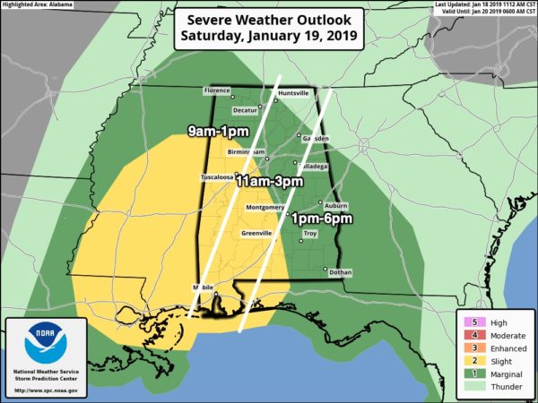
ACTIVE SATURDAY: A potent weather system will push showers and strong storms into Alabama tomorrow. SPC has defined a “slight risk” of severe storms (level 2/5) for the broad zone from Fayette and Tuscaloosa south to Florala, Gulf Shores, and Mobile. A “marginal risk” (level 1/5) covers much of the rest of the state.
This is a conditional severe weather threat; there will be very little surface based instability over the northern half of the state, where dynamic support is the best.
TIMING: The main window for strong to severe storms for West Alabama is from 9:00 a.m. until 1:00 p.m… Central Alabama from 11:00 a.m. until 3:00 p.m… and East Alabama from 1:00 until 6:00 p.m.
THREATS: Stronger storms could produce strong, potentially damaging winds, and an isolated short lived tornado is possible. The main threat of severe storms is across the “slight risk” area across West and Southwest Alabama.
RAIN AMOUNTS: Most communities will see 1 to 2 inches of rain tomorrow; while major flooding issues are not expected there could be a few localized problems.
WINDS: It will be a windy day, even away from thunderstorms gradient winds out of the south will average 12-22 mph with higher gusts.
COLD AIR RUSHES IN TOMORROW NIGHT: Rain will end from west to east tomorrow evening, followed by strong north winds, and some very cold air that is now lurking over the northern states. During initial rush of cold air, a few light snow flurries are possible across the northern half of the state from about midnight tomorrow night through 7:00 a.m. Sunday, but we expect no accumulation or impact.
We also expect no big issues with icy road conditions Sunday morning; the strong north wind along with lowering dew points should evaporate most of the moisture before temperatures reach the low 30s.
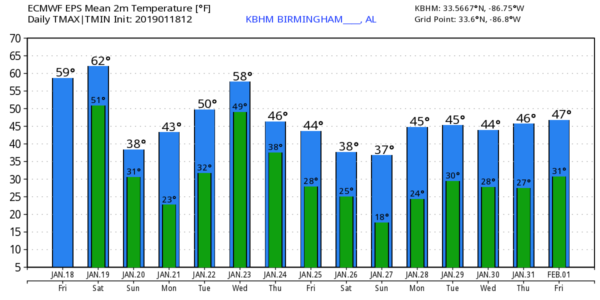
Then, during the day Sunday, the sky will clear with sunshine returning by afternoon, but the day will be windy and cold with a high in the 36-40 degree range.
LUNAR ECLIPSE: The sky will be clear for the total lunar eclipse Sunday night; it begins at 8:36p CT, and peaks at 11:12p CT. Bundle up, however, as temperatures will be below freezing.
NEXT WEEK: Monday morning will be clear and cold with a nearly calm wind; we project lows in the 15-25 range over the northern half of the state. The day will be sunny and Monday’s high will be close to 50 degrees. Clouds move in Tuesday, and we expect periods of rain Wednesday, Wednesday night, and into part of the day Thursday. Latest thermal profiles from global model output suggest this will be all liquid, with no snow or ice issues for Alabama. After the rain another shot of very cold air arrives Thursday night and Friday.
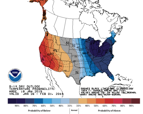
The pattern continues to favor cold air over the eastern half of the nation through the end of January. See the Weather Xtreme video for maps, graphics, and more details.
ON THIS DATE IN 1973: The first tornado death of the year has been registered north of Corey, Louisiana during the afternoon hours. Although a girl was killed when a tenant farm was destroyed, a baby received only minor injuries when it was carried 300 to 400 yards by the tornado.
BEACH FORECAST: Click here to see the AlabamaWx Beach Forecast Center page.
WEATHER BRAINS: Don’t forget you can listen to our weekly 90 minute show anytime on your favorite podcast app. This is the show all about weather featuring many familiar voices, including our meteorologists here at ABC 33/40.
CONNECT: You can find me on all of the major social networks…
Facebook
Twitter
Instagram
Pinterest
Snapchat: spannwx
I had a great time today visiting with the students at Oxford Elementary School… be looking for them on the Pepsi KIDCAM today at 5:00 on ABC 33/40 News! My next Weather Xtreme video will be posted here by 7:00 a.m. Monday… and stay tuned for frequent blog updates over the weekend!
Category: Alabama's Weather, ALL POSTS, Weather Xtreme Videos
About the Author (Author Profile)
James Spann is one of the most recognized and trusted television meteorologists in the industry. He holds the AMS CCM designation and television seals from the AMS and NWA. He is a past winner of the Broadcast Meteorologist of the Year from both professional organizations.Subscribe
If you enjoyed this article, subscribe to receive more just like it.


