Warm Weekend Ahead
TRENDING DRIER TODAY: Lingering showers across the northern half of Alabama will end this morning, and by afternoon the best chance of rain will shift down into the southern counties of the state, where a few thunderstorms will be possible as well. The sky becomes partly sunny across North/Central Alabama this afternoon with a high in the mid 70s.
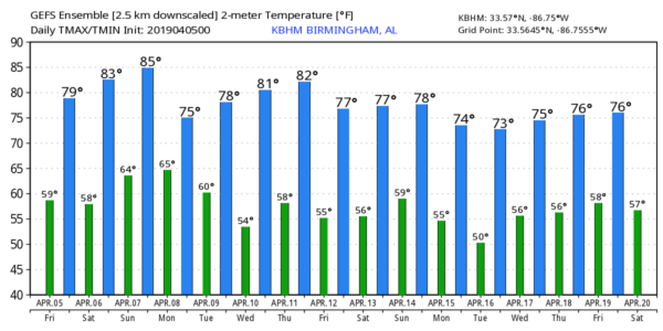
WARM WEEKEND AHEAD: This will be the warmest weekend so far this year for the Deep South; we project a high between 77 and 80 degrees tomorrow, followed by low 80s Sunday. A few widely scattered showers and thunderstorms are possible both days, but a decent part of the weekend will be dry with a mix of sun and clouds. Showers and storms become more numerous Sunday night, and SPC has defined a severe weather threat for parts of North and West Alabama on the “Day 3” outlook, which runs through 7:00 a.m. Monday.
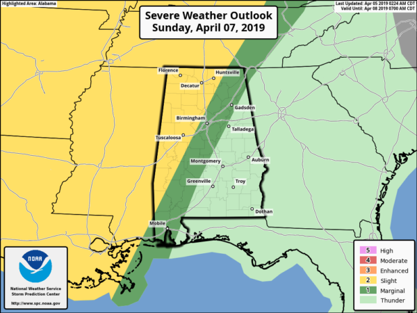
Some of the storms Sunday night could produce hail and strong gusty winds; we will be much more specific tomorrow.
NEXT WEEK: Monday will be wet and stormy with occasional showers and thunderstorms. Some of the storms could be strong, possibly severe, but it is too early to define the severe weather threat due to a number of variables that remain uncertain. Then, a few lingering showers are possible Tuesday morning, but the rest of the week, for now, looks dry. This is despite a rather vigorous system passing north of the state… at this point the air looks too dry for any significant chance of thunderstorms. See the Weather Xtreme video for maps, graphics, and more details.
ON THIS DATE IN 1936: A violent tornado moved through Tupelo, Mississippi killing 216… the fourth-deadliest tornado in United States history. Making its way toward Tupelo, the massive tornado killed a family of 13 as their house was swept away, and injured many more before reaching Tupelo’s west side. Retroactively rated EF-5 on the modern Enhanced Fujita scale, it caused total destruction along its path through the Willis Heights neighborhood. Dozens of large and well built mansions were swept completely away in this area. Although missing the business district, the tornado moved through the residential areas of north Tupelo, destroying many homes, and killing whole families. The Gum Pond area of Tupelo was the worst hit. Homes along the pond were swept into the water with their victims. The majority of the bodies were found in Gum Pond, the area which is now Gumtree Park. Notably, among the survivors were one-year-old Elvis Presley and his mother, Gladys. His father, Vernon, was out of town looking for work at that time.
IT’S THAT TIME AGAIN FOR INDYCAR AT BARBER: The Honda Indy Grand Prix of Alabama is today and over the weekend at the beautiful Barber Motorsports Park! Make plans for the event that has been voted “Best Annual Event” & “Best Sporting Event” in Birmingham. Kids 15 & under are admitted free with a ticketed adult, and three-day general admission tickets are $69. Single day tickets are as low as $15. Pack a picnic/cooler and bring the family out for a weekend full of activities and racing! For tickets, CLICK HERE.
BEACH FORECAST: Click here to see the AlabamaWx Beach Forecast Center page.
WEATHER BRAINS: Don’t forget you can listen to our weekly 90 minute show anytime on your favorite podcast app. This is the show all about weather featuring many familiar voices, including our meteorologists here at ABC 33/40.
CONNECT: You can find me on all of the major social networks…
Facebook
Twitter
Instagram
Pinterest
Snapchat: spannwx
I have a weather program this morning at Walter Kennedy Elementary in Pell City… look for the next Weather Xtreme video here by 4:00 this afternoon… enjoy the day!
Category: Alabama's Weather, ALL POSTS, Weather Xtreme Videos
About the Author (Author Profile)
James Spann is one of the most recognized and trusted television meteorologists in the industry. He holds the AMS CCM designation and television seals from the AMS and NWA. He is a past winner of the Broadcast Meteorologist of the Year from both professional organizations.Subscribe
If you enjoyed this article, subscribe to receive more just like it.


