Warm, Dry Through Tomorrow; Showers Return Late Thursday
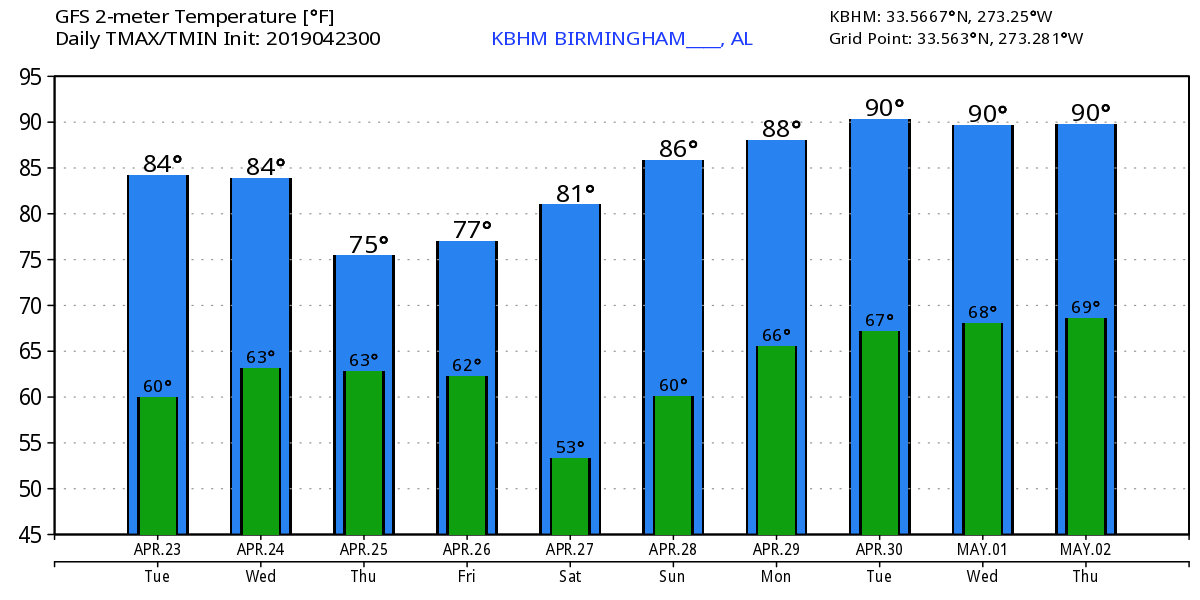
SUMMER PREVIEW: Yesterday’s official high in Birmingham was 83 degrees… we should beat that by a degree or two today and tomorrow as our summer preview continues. The sky will stay mostly sunny with a dry airmass holding in place.
THURSDAY/FRIDAY: Clouds will increase Thursday ahead of the next wave to the west, and rain will push into West Alabama late in the day. Showers and thunderstorms are likely statewide Thursday night, then ending early Friday morning. We note that SPC has defined a “marginal risk” (level 1/5) of severe storms for the southwest counties of the state Thursday night…
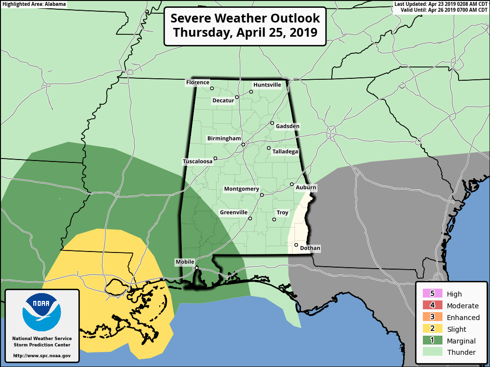
Some of the storms in that part of the state could produce strong gusty winds, but for most of Alabama we don’t expect any organized severe weather. Rain amounts will be generally 1/2 inch or less.
The sky becomes partly sunny Friday afternoon as drier air returns. The high both days will be in the upper 70s.
THE ALABAMA WEEKEND: Look for a good supply of sunshine both days with warm afternoons; afternoon highs will be in the low 80s. A weak surface front will creep into North Alabama Sunday night, but for now the air looks too dry for any meaningful precipitation.
RACE WEEKEND AT TALLADEGA: The weekend will be warm and dry; lots of sunshine for Talladega Saturday and Sunday with highs in the low 80s.
NEXT WEEK: A strong upper high builds across the Deep South, and it will feel more like summer with highs in the 86-90 degree range. Look for mostly sunny days and fair nights as the hot, dry pattern develops. See the Weather Xtreme video for maps, graphics, and more details.
RAIN UPDATE: Birmingham’s rain total for the year is 19.54″; the surplus is 1.71″. That surplus will begin to fade next week as a dry pattern develops.
ON THIS DATE IN 1999: On Friday, April 23, 1999, a horrific hailstorm moved southeast from Pennsylvania across Garrett County, Maryland and into the Eastern Panhandle of West Virginia. It had weakened some as it crossed Garrett County and the Allegany Front, but as it passed east of Keyser, West Virginia, hail began to increase in size once again. By the time it reached Capon Bridge in eastern Hampshire County, West Virginia, the size of the hail had grown from golf balls to baseballs. The damage left behind was incredible. In Northern Virginia alone, it amounted to over $50 million in losses to public and private properties. Some communities saw a third of the homes with siding and roof damage. Some required total replacement.
BEACH FORECAST: Click here to see the AlabamaWx Beach Forecast Center page.
WEATHER BRAINS: Don’t forget you can listen to our weekly 90 minute show anytime on your favorite podcast app. This is the show all about weather featuring many familiar voices, including our meteorologists here at ABC 33/40.
CONNECT: You can find me on all of the major social networks…
Facebook
Twitter
Instagram
Pinterest
Snapchat: spannwx
I have weather programs today in Shelby County at Creekview Elementary and Calera Intermediate School. Look for the next Weather Xtreme video here by 4:00 this afternoon… enjoy the day!
Category: Alabama's Weather, ALL POSTS, Weather Xtreme Videos
About the Author (Author Profile)
James Spann is one of the most recognized and trusted television meteorologists in the industry. He holds the AMS CCM designation and television seals from the AMS and NWA. He is a past winner of the Broadcast Meteorologist of the Year from both professional organizations.Subscribe
If you enjoyed this article, subscribe to receive more just like it.


