Dry Air Returns To Alabama Tomorrow
RADAR CHECK: We have a fairly large rain mass over Central Alabama at mid-afternoon; there have been a few rumbles of thunder, but the air is cool and stable and there is no risk of severe storms over the northern two-thirds of Alabama. A few severe storms remain possible along the I-10 corridor in far Southwest Alabama and the Florida Panhandle this evening, but so far the storms have been generally behaved.
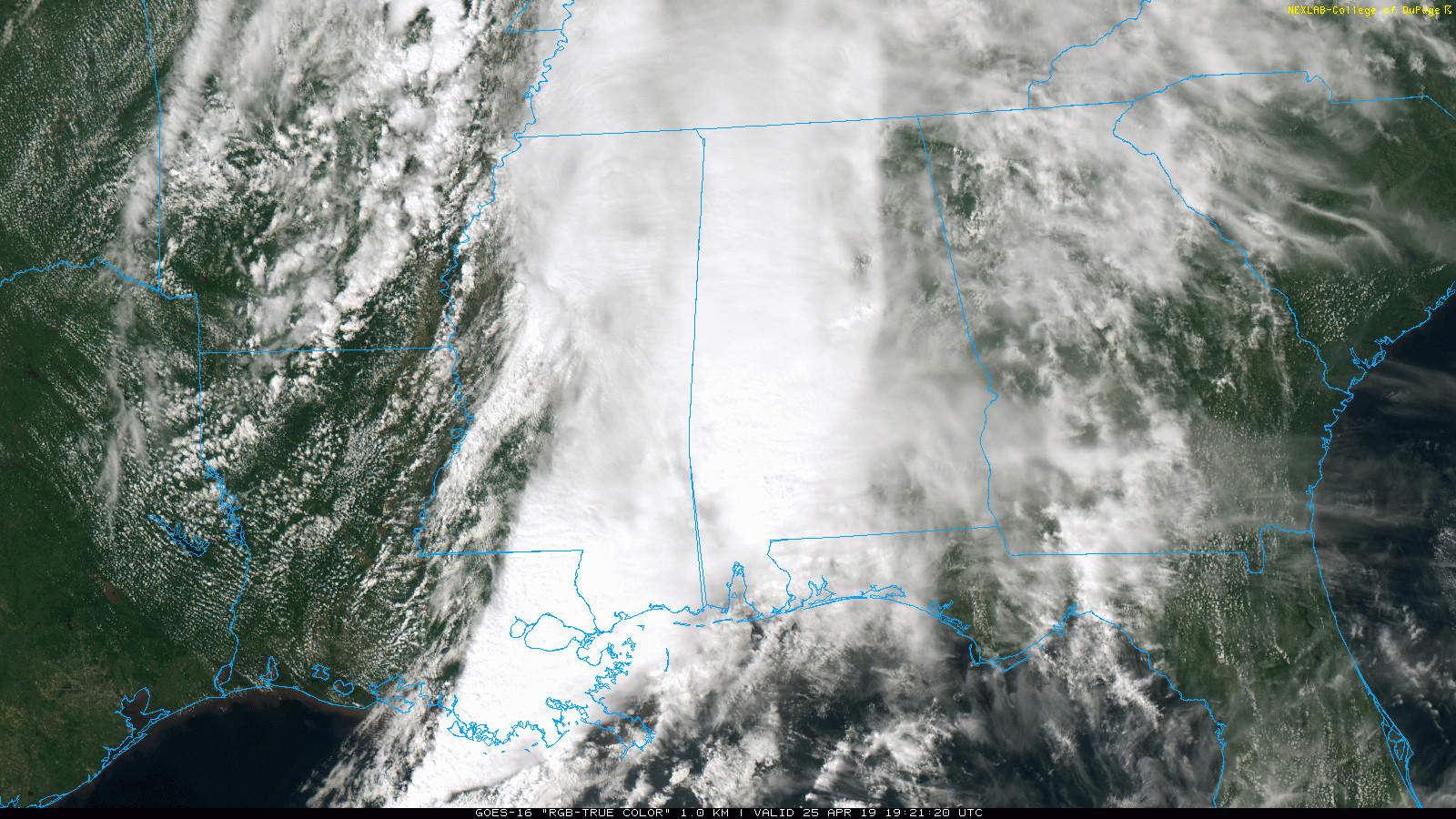
We will maintain the chance of lingering showers tonight, but the rain should be of out of the state soon after midnight as the upper wave moves on to the east.
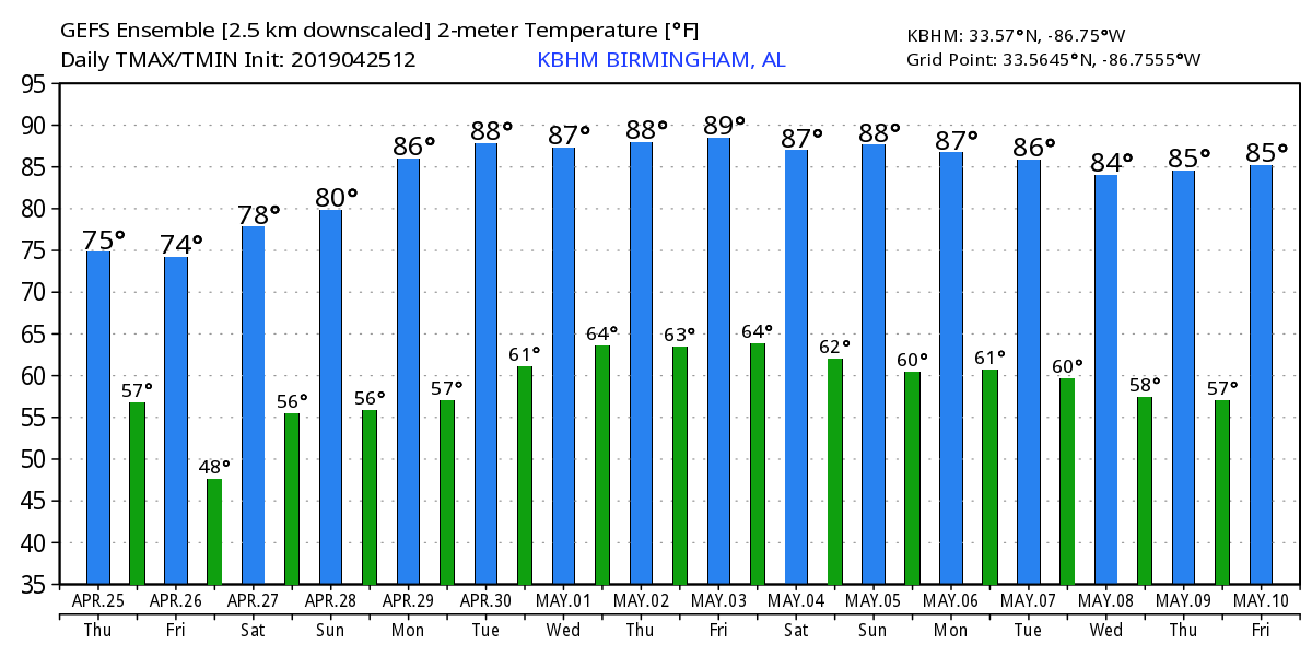
TOMORROW AND THE WEEKEND: Look for a good supply of sunshine tomorrow, but the day will be windy with a gusty northwest wind averaging 15-25 mph with higher gusts. The high will be in the 71-74 degree range, a little below average for late April in Alabama.
The weekend will be dry as well. A sunny sky Saturday; we start off the day with a low in the upper 40s… then expect a nice warm-up with a high between 77 and 80 degrees. The sky will be partly sunny sky Sunday with a high back in the upper 70s. A nice weekend for the races at Talladega.
NEXT WEEK: A strong upper ridge will build across the Deep South, meaning dry warm and dry weather for the first half of the week. Highs will be in the mid 80s for most communities. A few showers could show up over North Alabama late in the week, but rain should be fairly light under the ridge. See the Weather Xtreme video for maps, graphics, and more details.
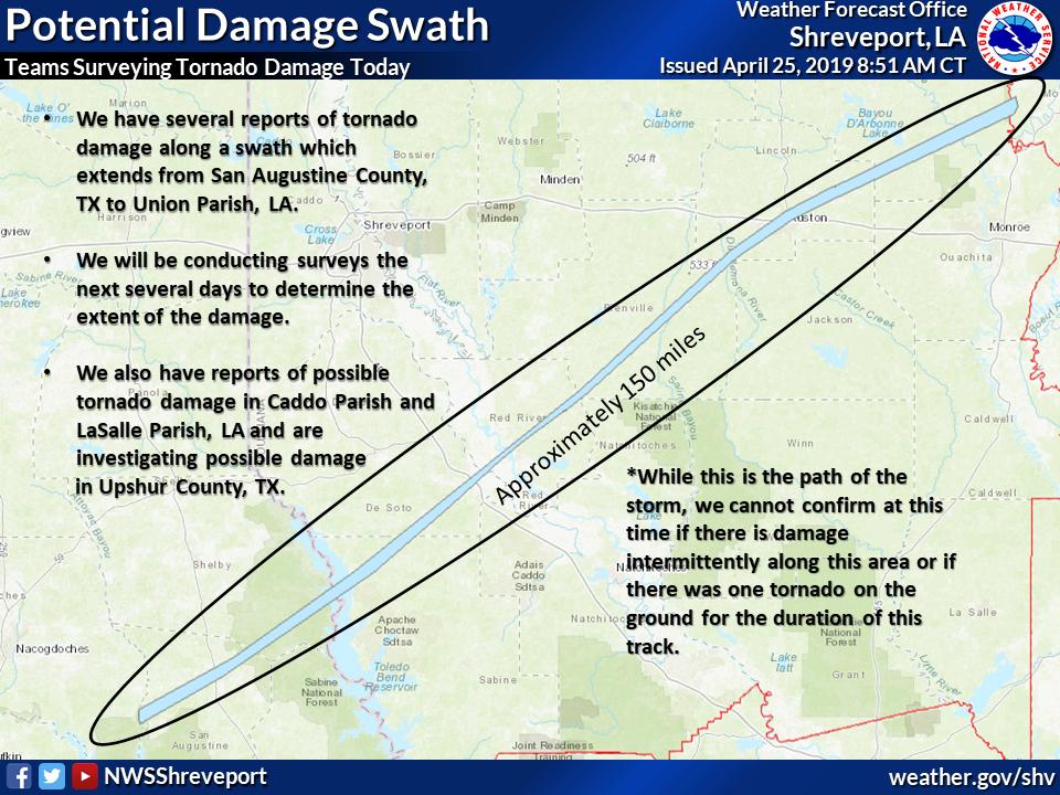
LONG TRACK TORNADO EARLY THIS MORNING: A long-tracked supercell thunderstorm crossed from Deep East Texas into West-Central Louisiana and into the ArkLaMiss region after midnight last night/early this morning. NWS Shreveport will be surveying along this swath over the next several days. At this time, they cannot confirm a tornado was on the ground along this entire path. The tornado at Ruston, Louisiana was rated EF-3, and two deaths were confirmed. There was significant damage across the Louisiana Tech campus.
ON THIS DATE IN 2011: The great tornado outbreak of April 2011 was underway. An intense supercell thunderstorm tracked near the Little Rock area and a tornado emergency was declared for the city of Vilonia. A large EF-2 wedge tornado struck the town, subsequently causing severe damage and killing four people. A strong EF-3 tornado had also struck the Hot Springs Village area earlier that evening; that tornado caused severe damage and resulted in one death. Later that evening, another EF-2 tornado caused extensive damage to both a school building and Little Rock Air Force Base as well. A total of 42 tornadoes and four tornado-related deaths were confirmed on the April 25, 2011.
BEACH FORECAST: Click here to see the AlabamaWx Beach Forecast Center page.
WEATHER BRAINS: Don’t forget you can listen to our weekly 90 minute show anytime on your favorite podcast app. This is the show all about weather featuring many familiar voices, including our meteorologists here at ABC 33/40.
CONNECT: You can find me on all of the major social networks…
Facebook
Twitter
Instagram
Pinterest
Snapchat: spannwx
I enjoyed seeing the 2nd graders today at Gresham Elementary, and the 3rd graders at Helena Intermediate… be looking for them on the Pepsi KIDCAM today at 5:00 and 6:00 on ABC 33/40 News! The next Weather Xtreme video will be posted here by 7:00 a.m. tomorrow…
Category: Alabama's Weather, ALL POSTS, Weather Xtreme Videos
About the Author (Author Profile)
James Spann is one of the most recognized and trusted television meteorologists in the industry. He holds the AMS CCM designation and television seals from the AMS and NWA. He is a past winner of the Broadcast Meteorologist of the Year from both professional organizations.Subscribe
If you enjoyed this article, subscribe to receive more just like it.


