Dry Air For Alabama; Dorian Becomes A Hurricane
SUNNY DAYS: A very dry airmass now covers Alabama, and most all of the state will be dry through Friday with sunny days, low humidity, and cooler nights. Look for lows between 60 and 65 degrees tomorrow and Friday morning, with 50s for the normally cooler places for a nice fall preview.
LABOR DAY WEEKEND: The northern half of Alabama will stay dry Saturday; we will mention a few scattered showers or storms for the southern quarter of the state. Then, on Sunday and Monday, with a partly sunny sky we will bring in a chance of widely scattered showers or storms, but we aren’t expecting anything really widespread.
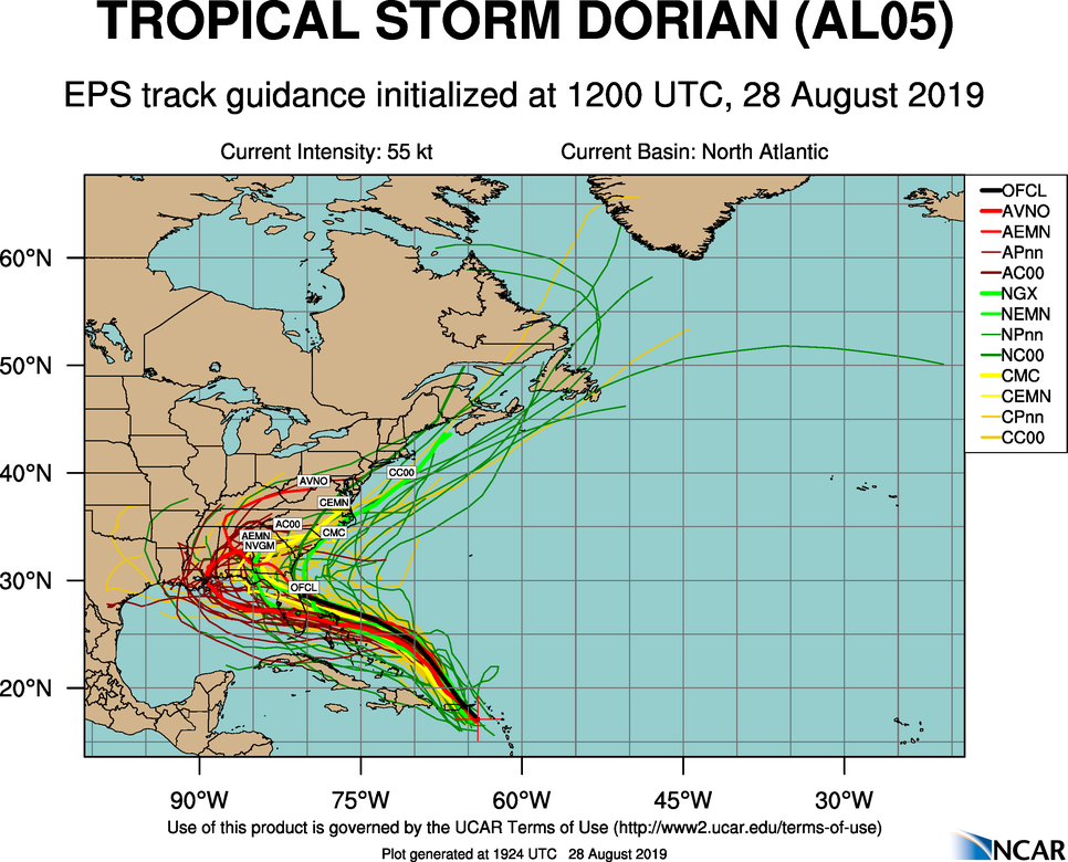
REST OF NEXT WEEK: The weather all depends on the track of Hurricane Dorian, and forecast confidence this far out is low. Models have trended further west with the system, meaning we could see some rain by mid to late week. How much rain all depends on the behavior of the tropical system. See the Weather Xtreme video for maps, graphics, and more details.

FOOTBALL WEATHER: Perfect weather for high school football games across the state tomorrow night and Friday night. Clear, low humidity, with temperatures falling from the low 80s at kickoff into the 70s during the second half.
UAB will host Alabama State tomorrow night at Birmingham’s Legion Field… kickoff is at 7:00p CT. The weather will be delightful. A clear sky with temperatures falling from near 85 at kickoff, into the 70s during the second half.
Alabama will take on Duke in the Chick Fil A Kickoff Classic in Atlanta (2:30p CT kickoff)… the game will be played indoors (Mercedes Benz Stadium), but outside the sky will be mostly sunny. Temperatures will peak close to 90 in Atlanta Saturday afternoon.
Auburn travels to Dallas/Fort Worth to take Oregon at AT&T Stadium Saturday evening (6:30p CT kickoff). Temperatures will top out in the mid 90s during the day Saturday with a sunny sky, falling though the 80s during the game.
ERIN: Erin is now a tropical depression in the Atlantic, and will become post-tropical by tomorrow as it moves toward the Canadian maritimes.

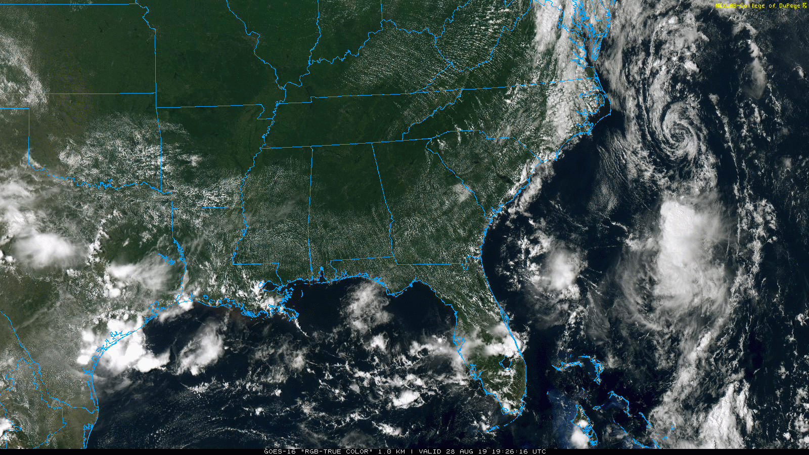
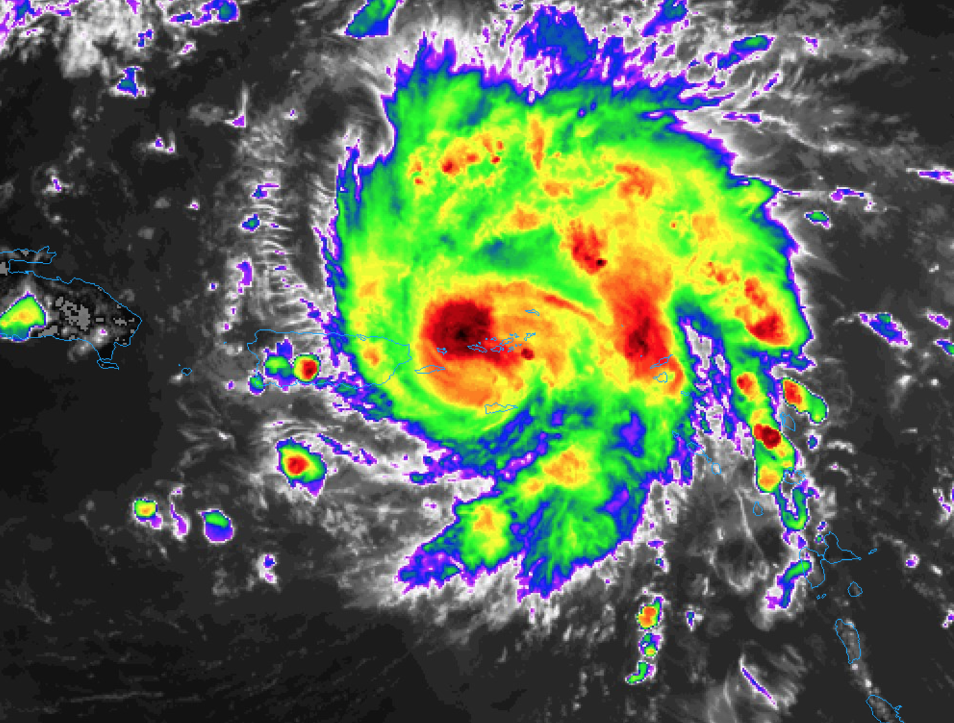
DORIAN: Now a hurricane with sustained winds of 75 mph, NHC is forecasting major hurricane status over the Labor Day weekend as it approaches the East Coast of Florida.
Important points…
*All indications are that by this Labor Day weekend, a powerful hurricane will be near the Florida or southeastern coast of the United States. The risk of dangerous storm surge and hurricane-force winds is increasing in the central and northwestern Bahamas and along the Florida east coast, although it is too soon to determine where these hazards will occur. Residents in these areas should ensure that they have their hurricane plan in place and not focus on the exact forecast track of Dorian’s center.
*New model runs (12Z) show a stronger upper high to the north of Dorian, meaning the westward motion could continue into early next week before the re-curve into the mid-latitude westerlies happens. Meaning, the Gulf Coast is not off the hook yet.
*If you are planning a trip to Disney World over the Labor Day weekend, weather continues will deteriorate in Orlando Sunday night and Monday with increasing rain and high winds. The weather Saturday and most of the day Sunday should be fairly routine with the usual risk of scattered storms along with a decent amount of sun.
*We do not expect any direct impact from Dorian along the Gulf Coast over the Labor Day weekend (Saturday through Monday)… including places like Gulf Shores, Destin, and Panama City Beach.
*IF there is an impact on the Central Gulf Coast, it will be toward the middle of next week. And, the same for inland parts of Alabama.
*Do not focus on the exact forecast track, as the average 5-day track error is around 200 miles. The forecast can, and will change. If you want the most accurate and up-to-date information, you will have to check the Dorian forecast several times a day. Otherwise, you’re working with old (and most likely bad) information.
ON THIS DATE IN 2005: Hurricane Katrina attained Category 5 status on the morning of August 28 and reached its peak strength at 1p CT that day, with maximum sustained winds of 175 mph and a minimum central pressure of 902 mb. It would make landfall the following day as a category three hurricane near Buras, LA, with sustained winds of more than 125 mph.
BEACH FORECAST: Click here to see the AlabamaWx Beach Forecast Center page.
WEATHER BRAINS: Don’t forget you can listen to our weekly 90 minute show anytime on your favorite podcast app. This is the show all about weather featuring many familiar voices, including our meteorologists here at ABC 33/40.
CONNECT: You can find me on all of the major social networks…
Facebook
Twitter
Instagram
Pinterest
Snapchat: spannwx
I had a great time today seeing the students at Munford Elementary… be looking for them on the Pepsi KIDCAM today at 5:00 on ABC 33/40 News! The next Weather Xtreme video will be posted here by 7:00 a.m. tomorrow…
Category: Alabama's Weather, ALL POSTS, Weather Xtreme Videos
About the Author (Author Profile)
James Spann is one of the most recognized and trusted television meteorologists in the industry. He holds the AMS CCM designation and television seals from the AMS and NWA. He is a past winner of the Broadcast Meteorologist of the Year from both professional organizations.Subscribe
If you enjoyed this article, subscribe to receive more just like it.


