Hot, Dry Weather For Alabama; Dorian Turns Northward Slowly
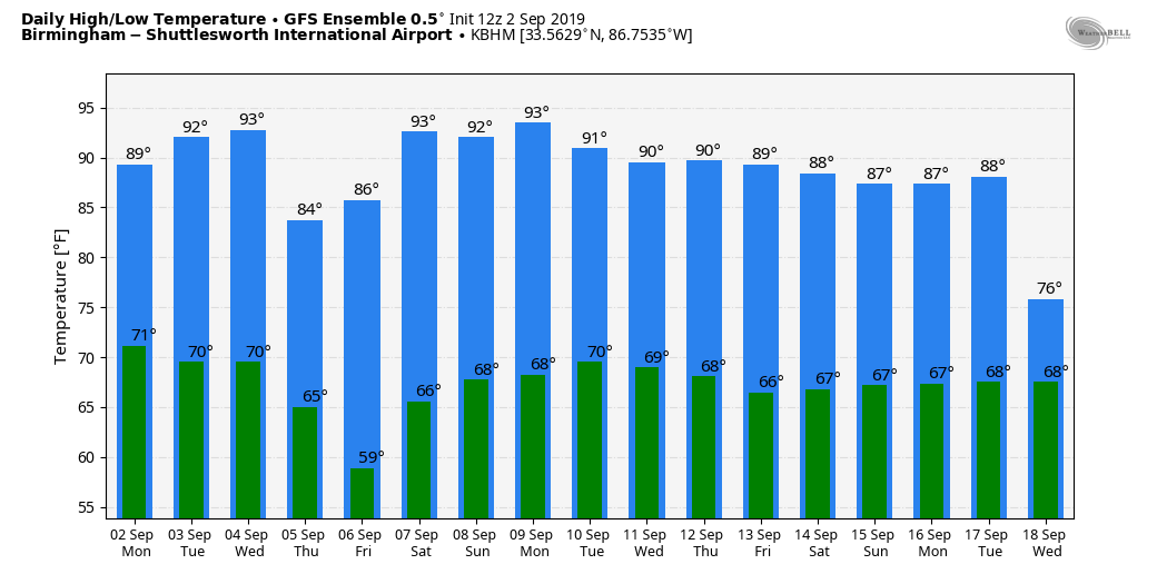
DRY DAYS: A very dry airmass will remain in place across Alabama through the weekend, meaning rain-free conditions with mostly sunny days and fair nights. Highs will be in the low to mid 90s tomorrow and Wednesday, then backing down into the 88-92 degree range Thursday and Friday following a dry frontal passage Wednesday night. Nights will be cooler later this week, and many places will drop into the 50s early Friday morning for a nice taste of fall.
We should mention “meteorological fall” started yesterday, but in terms of astronomy, the autumnal equinox comes this year at 2:50a CT on September 23. That is when the sun is directly over the equator and we have approximately 12 hours of daylight, and 12 hours of darkness.
THE ALABAMA WEEKEND: Not much change; look for mostly sunny weather Saturday and Sunday with a high not too far from 90 degrees. Morning lows will be in the 60s.
And, next week looks generally dry although we could see a few isolated showers on a day or two. See the Weather Xtreme video for maps, graphics, and more details.
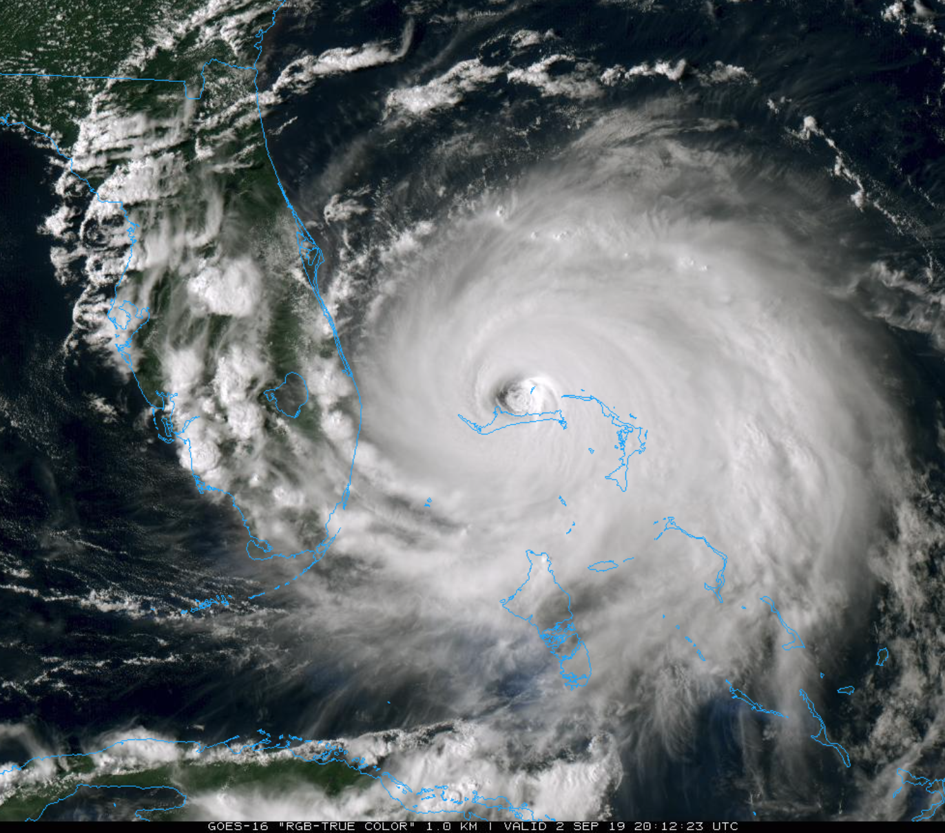
HURRICANE DORIAN: Dorian is packing sustained winds of 150 mph, and is moving northward very slowly. The hurricane is a dangerous category four on the Saffir-Simpson scale.
Important points…
*A prolonged period of catastrophic winds and storm surge will continue to affect Grand Bahama Island through today and tonight. Everyone there should remain in shelter and not venture into the eye.
*As Dorian moves very slowly during the next 24 hours, some upwelling in the deeper waters around the Bahamas could cause some gradual weakening. After that time, the hurricane is expected to experience a gradual increase in southwesterly shear, which should lead to a slow decrease in wind speed. However, Dorian is forecast to remain a very powerful hurricane while it moves near the southeastern United States coast.
*It cannot be stressed enough that only a small deviation to the left of the NHC forecast could bring the core of the extremely dangerous hurricane onshore of the Florida east coast within the hurricane warning area. In addition, Dorian’s wind field is predicted to expand, which would bring hurricane-force winds closer to the east coast of Florida even if the track does change.
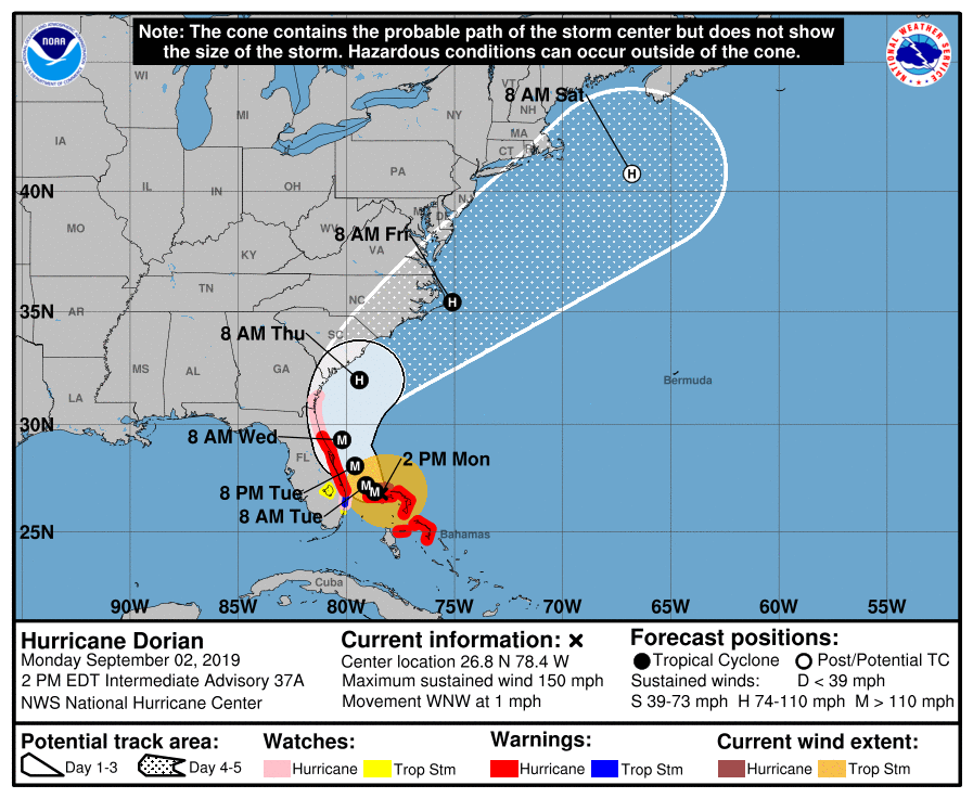
*A Hurricane Warning is in effect for…
Grand Bahama and the Abacos Islands in the northwestern Bahamas
Jupiter Inlet to the Volusia/Flagler County Line
*A Hurricane Watch is in effect for…
North of Deerfield Beach to Jupiter Inlet
Flagler/Volusia County Line to the Altamaha Sound Georgia
*Remember, a hurricane is not a dot on a map. Hurricane-force winds extend outward up to 45 miles from the center, and tropical-storm-force winds extend outward up to 140 miles.
*Life-threatening storm surge and dangerous hurricane-force winds are expected along portions of the Florida east coast and Georgia coast, regardless of the exact track of Dorian’s center. Water levels could begin to rise well in advance of the arrival of strong winds. Residents in these areas should follow advice given by local emergency officials.
*The risk of life-threatening storm surge and hurricane-force winds continues to increase along the coasts of South Carolina and North Carolina. Residents in these areas should follow advice given by local emergency officials.
*Individuals east of I-95 in Bryan, Camden, Chatham, Glynn, Liberty, and McIntosh counts in Georgia must evacuate beginning today.
*There is a mandatory evacuation of the entire South Carolina coastline today.
*Dorian will not impact Alabama or the Central Gulf Coast in any way.
REST OF THE TROPICS: NHC is watching four areas of interest….
*A tropical depression or storm is forecast to form in the western Gulf of Mexico tonight or tomorrow… it will move into Mexico; no threat to the U.S.
*A disturbance south of Bermuda could develop slowly in coming days; it is moving north toward the North Atlantic and is no threat to land.
*A wave in the eastern Atlantic, not far from the Cap Verde Islands, is expected to become a tropical storm soon, but it will gain latitude and should not be a threat to the U.S.
*A new wave coming off the coast of Africa could develop slowly this week; it will be watched, but remains to be seen if this will impact any land mass.
ON THIS DATE IN 1935: The 1935 Labor Day hurricane (formally known as Hurricane Three) was the most intense Atlantic hurricane to make landfall on record in terms of pressure, and tied with Hurricane Dorian for the strongest landfalling Atlantic hurricane by maximum sustained winds, with winds of 185 mph at landfall. It was also the most intense Atlantic hurricane on record until Hurricane Gilbert in 1988. Officially, 408 people lost their lives as a result of the storm, including over 250 veterans, but the death toll may have actually been much higher.
BEACH FORECAST: Click here to see the AlabamaWx Beach Forecast Center page.
WEATHER BRAINS: Don’t forget you can listen to our weekly 90 minute show anytime on your favorite podcast app. This is the show all about weather featuring many familiar voices, including our meteorologists here at ABC 33/40.
CONNECT: You can find me on all of the major social networks…
Facebook
Twitter
Instagram
Pinterest
Snapchat: spannwx
Look for the next Weather Xtreme video here by 7:00 a.m. tomorrow…
Category: Alabama's Weather, ALL POSTS, Weather Xtreme Videos
About the Author (Author Profile)
James Spann is one of the most recognized and trusted television meteorologists in the industry. He holds the AMS CCM designation and television seals from the AMS and NWA. He is a past winner of the Broadcast Meteorologist of the Year from both professional organizations.Subscribe
If you enjoyed this article, subscribe to receive more just like it.


