Hot, Dry Weather For Alabama Through The Weekend
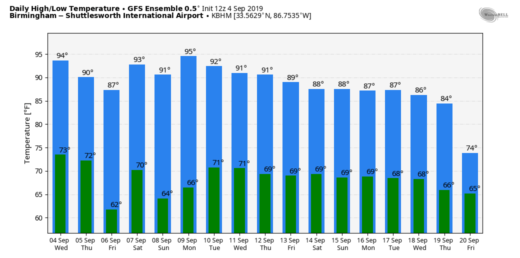
HOT SEPTEMBER DAY: Temperatures are in the low to mid 90s across Alabama this afternoon… about 5 degrees above average for early September (Birmingham’s average high for September 4 is 89). The air is dry, and the sky is sunny. A dry front comes through tonight, and the high tomorrow will be closer to 90.
FRIDAY AND THE WEEKEND: Look for sunny hot afternoons, and fair pleasant nights. The high will be in the low 90s Friday, followed by mid 90s over the weekend. Friday morning will be comfortable with some spots reaching the upper 50s.
FOOTBALL WEATHER: For the high school games Friday night, the sky will be clear with temperatures falling from the upper 80s at kickoff, into the upper 70s by the final whistle.
Saturday, Alabama hosts New Mexico State at Bryant-Denny Stadium in Tuscaloosa (3p CT kickoff)… it will be a sizzling afternoon with a kickoff temperature near 97 degrees, falling into the low 90s by the fourth quarter. The sky will be mostly sunny.
Auburn will host Tulane Saturday evening (6:30p CT kickoff)… the sky will be clear with temperatures falling from 90 degrees at kickoff into the upper 70s by the final whistle.
UAB is on the road… they travel to Akron, Ohio to play the Zips Saturday (11a CT kickoff). The sky will be mostly sunny with temperatures rising from the low 70s at kickoff, into the mid 70s by the fourth quarter.
NEXT WEEK: We could see a few showers Tuesday through Friday, but most likely they will be pretty isolated, and prospects of beneficial rain don’t look good. See the Weather Xtreme video for maps, graphics, and more details.
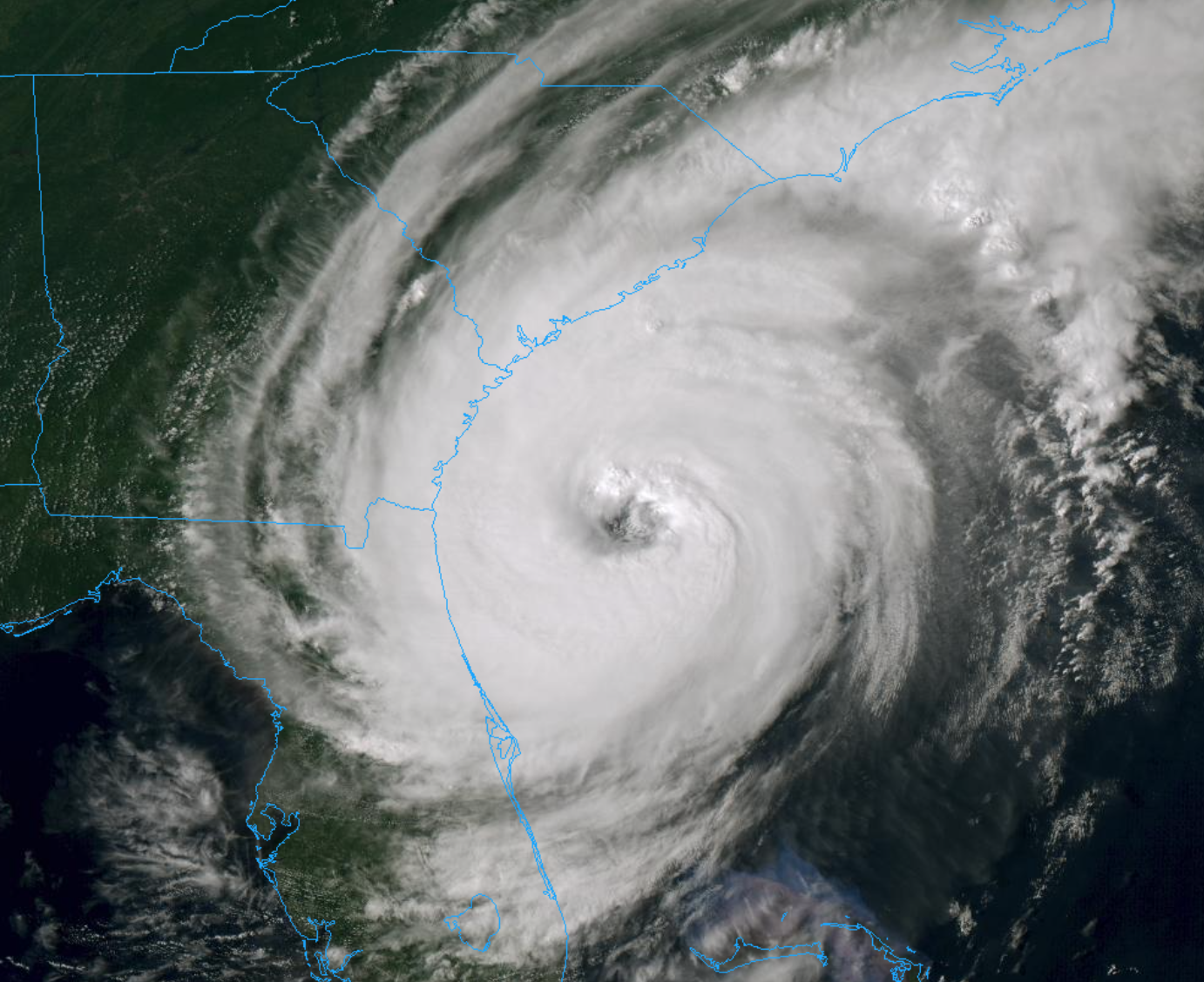
HURRICANE DORIAN: Hurricane Dorian is packing sustained winds of 105 mph, and is moving N/NW at 9 mph.
Important points…
*Dorian is moving around the western end of the subtropical ridge, and it should recurve northward and northeastward into the mid-latitude westerlies during the next 24-48 hours. This motion should bring the center of Dorian near or over the coast of North Carolina during the 36-48 h period. After that time, the cyclone is forecast to accelerate northeastward into the Atlantic toward the Canadian Maritimes, with a quick northeastward motion continuing for the remainder of the cyclone’s life.
The track guidance is very tightly clustered, and the new forecast track, which has only minor changes from the previous forecast, lies in the center of the guidance envelope near the consensus models. It should be noted that the track is close to and almost parallel to the coast of the southeastern United State, and any deviation to the left of the track could bring the center onshore anywhere in the Carolinas.
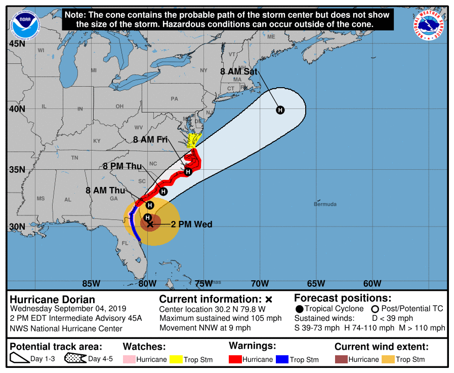
A Hurricane Warning is in effect for…
North of Savannah River to the North Carolina/Virginia border
Albemarle and Pamlico Sounds
*A Hurricane Watch is in effect for…
North of Ponte Vedra Beach FL to Savannah River
*Hurricane-force winds extend outward up to 70 miles from the center and tropical-storm-force winds extend outward up to 175 miles. NOAA buoy 41008, located off the Georgia coast, recently reported sustained winds of 40 mph and a wind gust of 47 mph.
*Life-threatening storm surge and dangerous winds are expected along portions of the Florida east coast and the coasts of Georgia, South Carolina, North Carolina, regardless of the exact track of Dorian’s center. Water levels could rise well in advance of the arrival of strong winds. Residents in these areas should follow advice given by local emergency officials.
*The risk of dangerous storm surge, wind, and rain impacts along portions of the Virginia coast and the southern Chesapeake Bay continues to increase. Residents in these areas should continue to monitor the progress of Dorian.
*Flash flooding will become increasingly likely across coastal Georgia into the eastern Carolinas tonight into Friday. There is a high risk of flash flooding over coastal sections of the Carolinas, where significant, life-threatening, flash flooding is expected.
TROPICAL STORM FERNAND: Fernand is moving into northern Mexico this afternoon, south of Brownsville, Texas. The system will dissipate inland over the next few days.
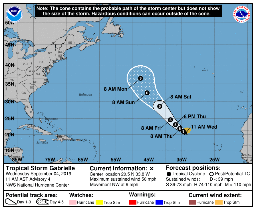
TROPICAL STORM GABRIELLE: This storm in the eastern Atlantic will gain latitude in coming days, moving into the open North Atlantic and is no threat to land.
INVEST 92L: A disturbance near Bermuda will move northeast, into the North Atlantic. Some slow development is possible, but this won’t be a threat to any land mass.
ELSEWHERE: A tropical wave will emerge off the coast of Africa tomorrow, and will have potential to become a tropical depression or tropical storm by early next week. It is too early to know if this will continue westward toward the Lesser Antilles, or turn northward into the open Atlantic. We will keep an eye on it.
ON THIS DATE IN 2011: The center of Tropical Storm Lee moved ashore around sunrise. However, it would be a while before Lee would weaken to a depression as it remained nearly stationary while the southern half of the circulation was over water where it could continue to derive additional energy from the warm ocean. Lee brought torrential rains to Louisiana, Mississippi, and Alabama.
BEACH FORECAST: Click here to see the AlabamaWx Beach Forecast Center page.
WEATHER BRAINS: Don’t forget you can listen to our weekly 90 minute show anytime on your favorite podcast app. This is the show all about weather featuring many familiar voices, including our meteorologists here at ABC 33/40.
CONNECT: You can find me on all of the major social networks…
Facebook
Twitter
Instagram
Pinterest
Snapchat: spannwx
I enjoyed seeing the 6th graders today at Clanton Middle School… be looking for them on the Pepsi KIDCAM today at 5:00 on ABC 33/40 News! The next Weather Xtreme video will be posted here by 7:00 a.m. tomorrow…
Category: Alabama's Weather, ALL POSTS, Weather Xtreme Videos
About the Author (Author Profile)
James Spann is one of the most recognized and trusted television meteorologists in the industry. He holds the AMS CCM designation and television seals from the AMS and NWA. He is a past winner of the Broadcast Meteorologist of the Year from both professional organizations.Subscribe
If you enjoyed this article, subscribe to receive more just like it.


