

Temperatures Above Average; Not Much Rain
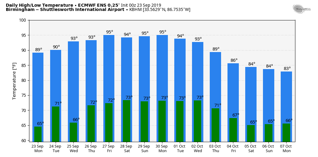
WELCOME TO FALL: Autumn official arrived early this morning at 2:50 a.m. CT… this is the day when the sun is directly over the equator, and we have approximately 12 hours of daylight, and 12 hours of darkness. But, the weather will still feel like summer this week as afternoon temperatures will remain above average. Highs will generally be in the 89-92 degree range this week with partly sunny days.
We will mention the chance of a few widely scattered showers and thunderstorms this afternoon and early tonight over the northern quarter of the state ahead of a weak front. As that boundary shifts slowly southward, a few isolated showers or storms are possible over the northern half of the state tomorrow through Friday, but nothing really widespread. Certainly not the kind of rain we need to ease the drought conditions.
THE ALABAMA WEEKEND: A strong upper high will be right on top of us, so the “endless summer” continues with a good supply of sunshine both days along with highs potentially in the mid 90s, right at record levels for late September in Alabama.
NEXT WEEK: Not much change. The pattern continues to look dry with above average temperatures as the ridge holds. Highs will be around 90 degrees… See the Weather Xtreme video for maps, graphics, and more details.
TROPICS: We have three systems on the map this morning…
*Tropical Storm Jerry in the Atlantic, now with winds of 65 mph, will pass close to Bermuda Wednesday before heading eastward, away from the U.S.
*Tropical Depression 13 formed last night in the far eastern Atlantic; it is expected to become Hurricane Lorenzo within 48 hours. It will gain latitude, and global model output suggests this will turn north into the open Atlantic well east of the U.S. and the Lesser Antilles. Seems to be no threat to land.
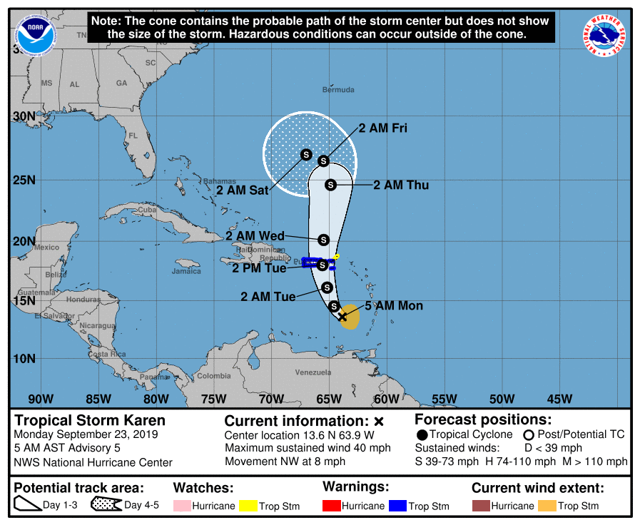
*Tropical Storm Karen is in the eastern Caribbean, and is moving northward. It will pass over Puerto Rico tomorrow and then will slow down late in the week as it encounters a ridge north of the system. Most global models suggest Karen will bend westward, in the general direction of Florida, this weekend in response to the ridge; interests in Florida and the Gulf of Mexico need to keep an eye on this. Way to early to know the final destination or impact.
ON THIS DATE IN 1975: Eloise made landfall as a major hurricane about 10 miles east of Fort Walton Beach, FL (Okaloosa County) at approximately 7am CDT. According to the NOAA Assessment, Herbert Saffir estimated winds in excess of 120 mph based on the structural wind damage he observed in Eloise. Shortly after Eloise made landfall, a peak wind gust of 115 mph was recorded at Eglin AFB (before the instrument failed) with 85 mph gusts at Hurlburt Field. Eloise was the first major hurricane to strike the region in 4 decades, yet did not have any fatalities directly related to the storm. However, there were 4 fatalities reported across Florida and Alabama indirectly related to Eloise. The 2 deaths in Alabama occurred after the storm from a tree falling during clean-up operations and electrocution from a downed power line.
BEACH FORECAST: Click here to see the AlabamaWx Beach Forecast Center page.
WEATHER BRAINS: Don’t forget you can listen to our weekly 90 minute show anytime on your favorite podcast app. This is the show all about weather featuring many familiar voices, including our meteorologists here at ABC 33/40.
CONNECT: You can find me on all of the major social networks…
Facebook
Twitter
Instagram
Pinterest
Snapchat: spannwx
I have a weather program this morning at Deer Valley Elementary in Hoover… look for the next Weather Xtreme video here by 4:00 this afternoon. Enjoy the day!
Category: Alabama's Weather, ALL POSTS, Weather Xtreme Videos
About the Author (Author Profile)
James Spann is one of the most recognized and trusted television meteorologists in the industry. He holds the AMS CCM designation and television seals from the AMS and NWA. He is a past winner of the Broadcast Meteorologist of the Year from both professional organizations.Subscribe
If you enjoyed this article, subscribe to receive more just like it.


