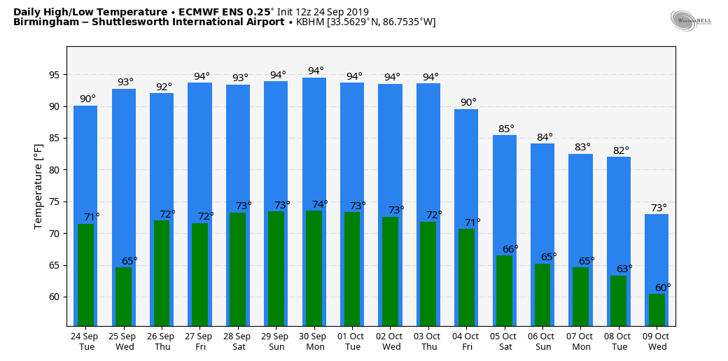
Afternoon Temperatures Remain Above Average
COOL START: A surface front is draped across Central Alabama this morning; north of the front we are seeing temperatures well down in the 50s as the day begins… some of the cooler spots:
Black Creek (just northeast of Gadsden) 50
Fort Payne 53
Gadsden 54
Pell City 55
Talladega 56
Cullman 57
Sylacauga 59
Temperatures will warm quickly today, and we will be in the low to mid 90s again this afternoon. And, we will mention a few widely scattered showers or storms this afternoon as the front begins to drift northward, but most places will remain dry.
TOMORROW/FRIDAY: Not much change; widely scattered, mostly afternoon and evening showers and storms remain possible both days, but odds of any one spot getting wet remain in the 10-20 percent range. Otherwise expect partly sunny days with highs between 91 and 95.
THE ALABAMA WEEKEND: A strong upper ridge means hot and generally dry weather Saturday and Sunday; partly to mostly sunny both days with highs in the mid 90s, right at record levels for late September. Here are the daily record highs…
September 28 94 (1986)
September 29 96 (1904)
A few isolated showers are possible Saturday afternoon over far Northeast Alabama, but again most places will stay dry.
NEXT WEEK: Hot, mostly dry weather continues for the first half of the week, but we are seeing evidence in global models that the ridge will break down toward the end of the week with potential for a few showers, and noticeably cooler air. See the Weather Xtreme video for maps, graphics, and more details.
FOOTBALL WEATHER: Mostly clear and warm for the high school games Friday night; temperatures will fall from the low 80s at kickoff into the 70s by the second half of the games.
Saturday, Alabama hosts Ole Miss at Bryant-Denny Stadium (2:30p CT kickoff)… the sky will be sunny with temperatures in the mid 90s at kickoff, falling back to near 90 by the fourth quarter.
Auburn will host Mississippi State Saturday evening at Jordan-Hare Stadium (6:00p CT kickoff)… the sky will be clear with temperatures falling from near 89 at kickoff into the low 80s by the final whistle.
UAB travels to Bowling Green to take on Western Kentucky Saturday evening (6:00p CT kickoff)… clear weather is the forecast with a kickoff temperature near 87 degrees, falling to near 80 by the fourth quarter.
Jacksonville State will also be on the road; they play Austin Peay in Clarksville, Tennessee Saturday afternoon (2:00p CT kickoff)… expect a sunny sky with temperatures in the low 90s at kickoff, falling into the upper 80s by the end of the game.
TROPICS: Jerry has become post-tropical in the Atlantic; it will pass by Bermuda today as it moves eastward. Lorenzo, in the eastern Atlantic, is now the fifth hurricane of the season… it will turn northward well before reaching the U.S.
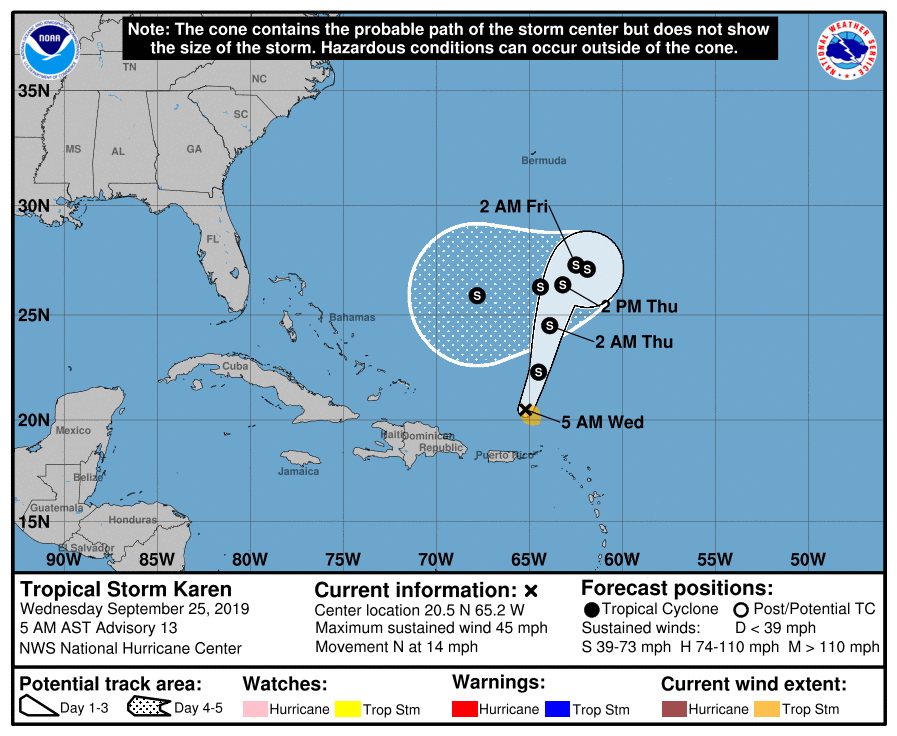
Tropical Storm Karen is now north of Puerto Rico with winds of 45 mph. It is moving northward, and is expected to slow turn and turn to the west/southwest this weekend in response to a ridge north of the system. Still too early to know if this will impact Florida or the Gulf of Mexico, but something to watch.
ON THIS DATE IN 1998: Four hurricanes were spinning simultaneously in the Atlantic basin: Georges, Ivan, Jeanne, and Karl. That was the first time this had happened since 1893.
BEACH FORECAST: Click here to see the AlabamaWx Beach Forecast Center page.
WEATHER BRAINS: Don’t forget you can listen to our weekly 90 minute show anytime on your favorite podcast app. This is the show all about weather featuring many familiar voices, including our meteorologists here at ABC 33/40.
CONNECT: You can find me on all of the major social networks…
Facebook
Twitter
Instagram
Pinterest
Snapchat: spannwx
I have a weather program this morning at Minor Community School… then I will be speaking at the weekly meeting of the Gadsden Kiwanis Club. Look for the next Weather Xtreme video here by 4:00 this afternoon. Enjoy the day!
Category: Alabama's Weather, ALL POSTS, Weather Xtreme Videos
About the Author (Author Profile)
James Spann is one of the most recognized and trusted television meteorologists in the industry. He holds the AMS CCM designation and television seals from the AMS and NWA. He is a past winner of the Broadcast Meteorologist of the Year from both professional organizations.Subscribe
If you enjoyed this article, subscribe to receive more just like it.


