

Long Awaited Cold Front Now Over North Alabama
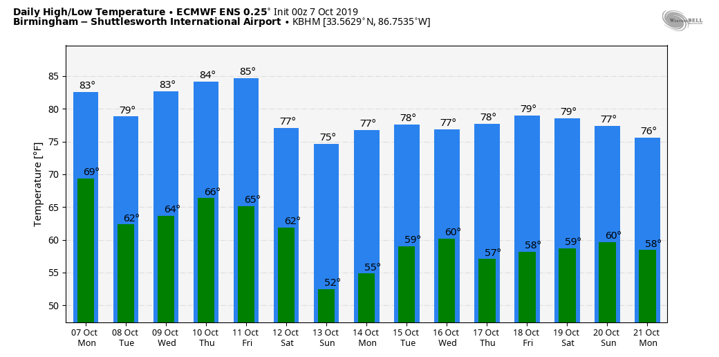
RADAR CHECK: Widespread rain, along with a few thunderstorms, is over North Alabama this morning along the long awaited cold front pushing into the state. The front, and the associated rain band, will push southward today keeping temperatures in the 70s all day over the northern half of the state. Heaviest rain will fall today north of I-59; amounts of 1/2 to 1 inch are likely, with heavier totals over the Tennessee Valley.
REST OF THE WEEK: Tomorrow will feature a mix of sun and clouds along with a high around 80 degrees; the average high for October 8 at Birmingham is 78. We will mention a few isolated showers over the eastern half of the state, but most of Alabama will be dry. Then, generally dry weather is likely Wednesday and Thursday… the sky will be partly to mostly sunny with highs between 81 and 85. Morning lows will be in the 60-65 degree range, with 50s for cooler pockets.
Clouds will increase Friday ahead of the next cold front, which could bring some rain to the state Friday night. For now it looks like rain will be fairly light (amounts under a quarter of an inch).
THE ALABAMA WEEKEND: Another surge of cool, continental air will drop into Alabama over the weekend. Look for sunny pleasant days and clear cool nights Saturday and Sunday… highs in the 70s and lows in the low 50s. Colder spots will drop down into the 40s Sunday morning.
NEXT WEEK: Dry, pleasant weather will continue for at least the first half of the week with seasonal temperatures… See the Weather Xtreme video for maps, graphics, and more details.
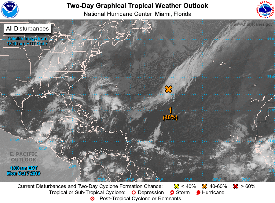
TROPICS: NHC is monitoring a disturbance in the Central Atlantic; it has a medium chance of development, but it will move northeast, away from the U.S. The Gulf of Mexico is quiet.
OCTOBER 2 HIGH ADJUSTED: A change was made to one of the temperatures recorded at Birmingham (BHM) last week, on October 2. The reported temperature of 103 was suspicious, and after further investigation, NWS Birmingham determined that the temperature was unreasonable. The 1 minute data from the site showed a spike in temperature up to 106, over a 15 minute period, around 1:30 in the afternoon. Removing this temperature, the highest observation in the afternoon then becomes 99 degrees. This new temperature of 99 degrees matches the trends from the several days leading up to October 2nd, and blends well with sites across central Alabama on that day. The high 99 degrees remains a record, breaking the old daily record maximum of 93 in 1904.
ON THIS DATE LAST YEAR: A tropical depression formed in the Caribbean; the next day it would become a hurricane, getting the name “Michael”. The hurricane strengthened rapidly in the Gulf of Mexico, reaching major hurricane status on October 9. It would go on to make landfall as a category five hurricane near Panama City Beach, Florida.
BEACH FORECAST: Click here to see the AlabamaWx Beach Forecast Center page.
WEATHER BRAINS: Don’t forget you can listen to our weekly 90 minute show anytime on your favorite podcast app. This is the show all about weather featuring many familiar voices, including our meteorologists here at ABC 33/40.
CONNECT: You can find me on all of the major social networks…
Facebook
Twitter
Instagram
Pinterest
Snapchat: spannwx
I am speaking to the monthly meeting of the Odenville Chamber of Commerce today… look for the next Weather Xtreme video here by 4:00 this afternoon. Enjoy the day!
Category: Alabama's Weather, ALL POSTS, Weather Xtreme Videos
About the Author (Author Profile)
James Spann is one of the most recognized and trusted television meteorologists in the industry. He holds the AMS CCM designation and television seals from the AMS and NWA. He is a past winner of the Broadcast Meteorologist of the Year from both professional organizations.Subscribe
If you enjoyed this article, subscribe to receive more just like it.


