Wet At Times Through Tomorrow Night
UNSETTLED WEATHER: As advertised, we have widespread rain across Alabama this morning ahead of warm front over the southern counties of the state, and a tropical system in the western Gulf of Mexico. Rain will continue through the day, but by afternoon South Alabama should get a back as the warm front continues to move slowly northward. We will continue the chance of rain for the northern counties tonight; heaviest rain will fall over North and West Alabama over the next 18 hours.
The air will be cool and stable over the northern half of the state with temperatures holding in the 60s, so there is no risk of severe storms, and probably very little lightning.
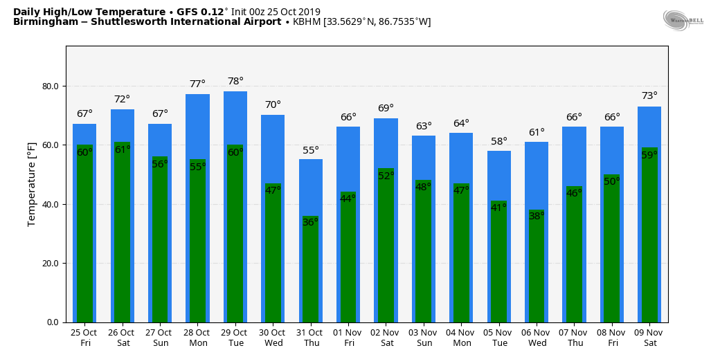
TOMORROW: The warm front will move into southern Tennessee, and the weather should be fairly quiet early in the day with a cloudy sky and only isolated showers. Then, by afternoon, showers and storms will increase ahead of a cold front. Rain will end from west to east tomorrow night as the front advances eastward.
While a strong storm can’t be ruled out, we don’t expect organized severe weather tomorrow with limited instability and weak lapse rates. The day tomorrow will be rather windy with a southeast wind averaging 10-20 mph with higher gusts.
Rain over the next 48 hours will be in the 2-4 inch range for North and West Alabama, with 1-2 inches likely for the eastern and southern counties of the state. A flash flood watch is in effect for Choctaw, Washington, and Mobile counties of Southwest Alabama, where rain will be enhanced by the tropical system now in the western Gulf. Flooding is not expected in other parts of the state.
The high tomorrow will be in the 70s.
SUNDAY AND NEXT WEEK: The sky becomes partly sunny Sunday as dry air returns; the high will be in the 67-71 degree range. The weather will stay dry and mild Monday and Tuesday, then we will bring in a good chance of rain Wednesday ahead of a cold front, which should bring the coldest air so far this season by the end of the week. Some places across North/Central Alabama could see their first freeze of the season in 6-7 days. See the Weather Xtreme video for maps, graphics, and more details.
TROPICS: The disturbance in the western Gulf is expected to become a short lived tropical depression today; it will merge with a cold front tonight, becoming post-tropical. This feature will enhance rain later today and tonight over parts of Louisiana, Mississippi, and far Southwest Alabama, where flash flood watches are in effect.
FOOTBALL WEATHER: For the high school games tonight, the sky will be cloudy with rain likely over the northern third of Alabama; temperatures will be in the 60s. Showers will be more scattered in nature over the southern 2/3 of the state.
For tomorrow’s Magic City Classic at Legion Field in Birmingham (Alabama State vs Alabama A&M, 2:30p CT kickoff), the sky will be cloudy, and occasional showers are likely. A thunderstorm can’t be ruled out, but there will be good breaks in the rain. Kickoff temperature near 74 degrees, falling to near 70 by the final whistle.
Auburn travels to Baton Rouge tomorrow to take on LSU (2:30p CT kickoff)… the sky will be mostly cloudy, and it now looks like most of the rain will be over by the time the game begins… just an outside risk of a lingering shower during the first half. Temperatures will fall from near 67 at kickoff into the low 60s by the fourth quarter.
It is homecoming at the University of Alabama tomorrow; the Tide will host Arkansas at Bryant-Denny Stadium (6:00p CT kickoff). It looks like rain will fall at times, mostly during the first half of the game. A thunderstorm will be possible as well. Temperatures will fall from near 70 at kickoff, into the upper 60s by the second half.
Jacksonville State will host Murray State tomorrow (3:00p CT kickoff)… cloudy conditions are expected with a good chance of showers; temperatures will be close to 70 degrees during the game.
ON THIS DATE IN 2008: A storm packing winds of more than 60 mph hits central Alberta. In Edmonton, the strongest October wind ever recorded reaches 64 mph, cutting power to 4,000. The winds blow free sheet metal, parts of billboards, garbage cans and pieces of trees around the city.
BEACH FORECAST: Click here to see the AlabamaWx Beach Forecast Center page.
WEATHER BRAINS: Don’t forget you can listen to our weekly 90 minute show anytime on your favorite podcast app. This is the show all about weather featuring many familiar voices, including our meteorologists here at ABC 33/40.
CONNECT: You can find me on all of the major social networks…
Facebook
Twitter
Instagram
Pinterest
Snapchat: spannwx
Look for the next Weather Xtreme video here by 4:00 this afternoon. Enjoy the day!
Category: Alabama's Weather, ALL POSTS, Weather Xtreme Videos
About the Author (Author Profile)
James Spann is one of the most recognized and trusted television meteorologists in the industry. He holds the AMS CCM designation and television seals from the AMS and NWA. He is a past winner of the Broadcast Meteorologist of the Year from both professional organizations.Subscribe
If you enjoyed this article, subscribe to receive more just like it.


