

Mild Today; Wet Tomorrow And Much Colder
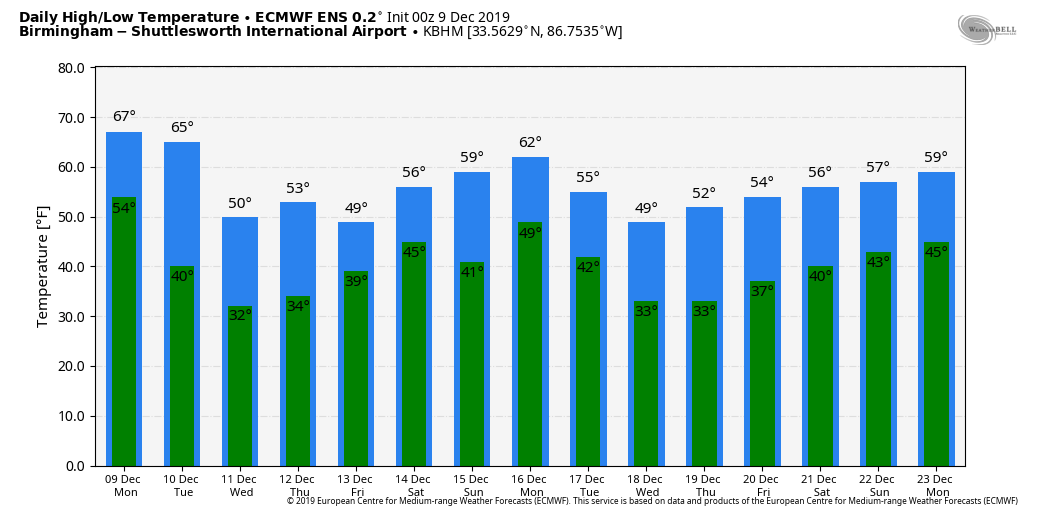
MILD AFTERNOON AHEAD: We are projecting a high in the 66-71 degree range for much of North/Central Alabama this afternoon; the average high for December at Birmingham is 57. The sky will be mostly cloudy, and we note some patchy light rain early this morning over East-Central Alabama. But, a decent part of the day will be rain-free.
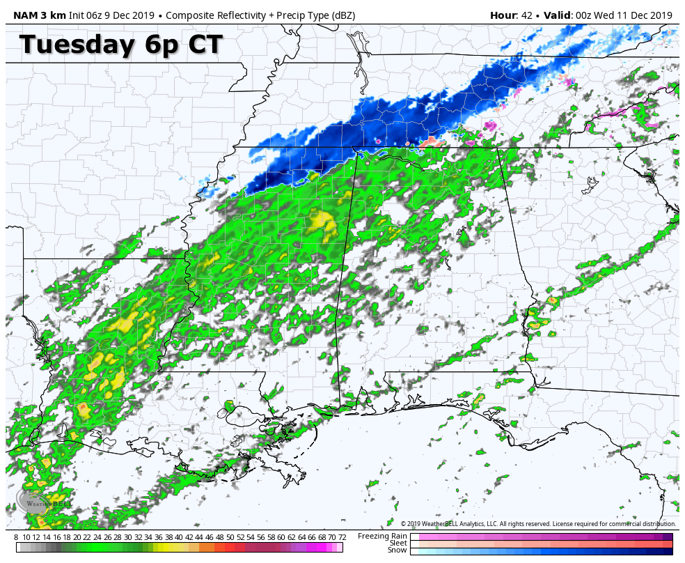
WET/COLDER TOMORROW: Clouds will stay in place tomorrow, and rain become widespread by afternoon into tomorrow night over the northern half of the state. No risk of severe storms as the air will be stable. In fact, temperatures tomorrow will go the wrong way. For places like Birmingham, Tuscaloosa, Anniston, and Gadsden, we start the day in the 60s around daybreak, but then we fall through the 50s and 40s during the day as the rain falls with chilly northwest wind. By tomorrow evening, we expect temperatures in the 30s over the Tennessee Valley, with low 40s for the central counties of the state.
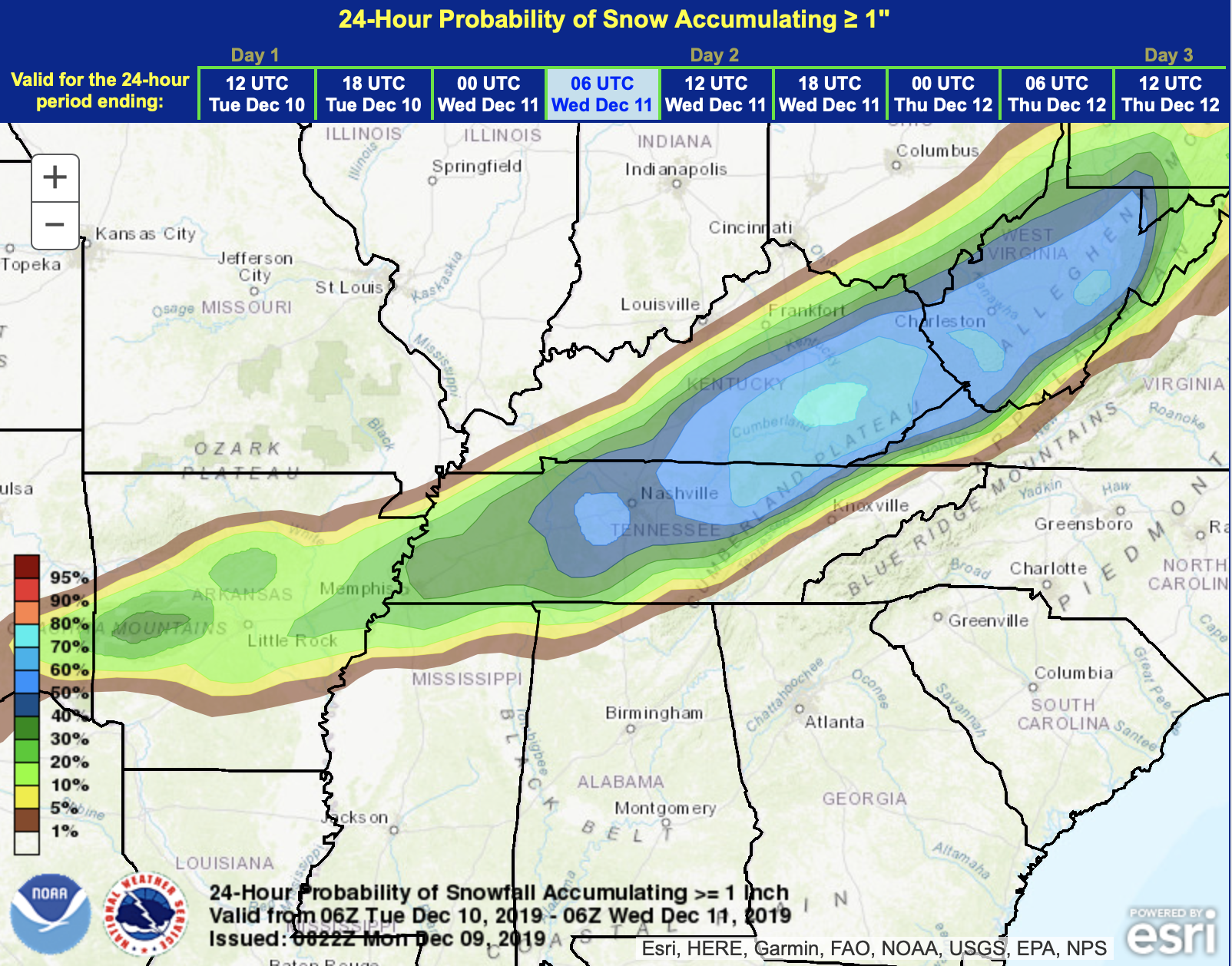
SNOW FLAKES? Forecast atmospheric profiles suggest the rain could change to a period of light snow, or snow flurries, over the northern quarter of Alabama late in the day and tomorrow night. Best chance of seeing a few snowflakes will be north of U.S. 278 (Hamilton to Cullman to Gadsden). For those geographically challenged, cities like Birmingham, Anniston, and Tuscaloosa are south of U.S. 278.
IF there is any accumulation in Alabama, it should be over the far northwest corner of the state, around Muscle Shoals. This is where surface temperatures will be hovering around the freezing mark, and there will still be some good forcing (upward motion in the atmosphere) before the precipitation ends. The change to snow for the Shoals should come between 3 and 6 p.m. There is potential for 1/4 to 1/2″ across far Northwest Alabama.
However, for the rest of North Alabama, no significant accumulation or impact is forecast for now with temperatures in the mid 30s and warm soil temperatures. All precipitation will end after midnight tomorrow night.
WEDNESDAY/THURSDAY: Wednesday will be a mostly cloudy and cool day, with some potential for clearing by mid to late afternoon over the northern counties of the state. Some lingering light rain is possible over the southern quarter of Alabama Wednesday. Then, on Thursday, we expect a mix of sun and clouds. Highs will be generally in the mid 50s both days.
FRIDAY AND THE WEEKEND: A broad area of low pressure moving out of the Gulf of Mexico will bring more rain to Alabama Friday and Friday night; rain amounts of 1/2 to 1 inch look likely with this event. Then, on Saturday, an upper trough will keep some risk of scattered light rain in the forecast, but a decent part of the day should be dry. Sunday will be rain-free with a partly sunny sky. Highs will remain in the 50s on these three days.
NEXT WEEK: The next wave will bring chance rain to the state early in the week, late Monday and Monday night… then drier air returns Tuesday afternoon and Tuesday night. See the Weather Xtreme video for maps, graphics, and more details.
The good news is that we see no risk of severe thunderstorms in Alabama for the next 10-15 days… we are still in the core of the late fall/early winter tornado season.
ON THIS DATE IN 2003: Although it never threatened land, a subtropical storm became Tropical Storm Peter approx. 700 miles WNW of the Cape Verde Islands. Combined with Tropical Storm Odette from earlier in the month, this is the first time since 1887 that two tropical storms formed in the Atlantic Basin in December.
BEACH FORECAST: Click here to see the AlabamaWx Beach Forecast Center page.
WEATHER BRAINS: Don’t forget you can listen to our weekly 90 minute show anytime on your favorite podcast app. This is the show all about weather featuring many familiar voices, including our meteorologists here at ABC 33/40.
CONNECT: You can find me on all of the major social networks…
Facebook
Twitter
Instagram
Pinterest
Snapchat: spannwx
I have a weather program this morning at Gwin Elementary in Hoover…. look for the next Weather Xtreme video here by 4:00 this afternoon. Enjoy the day!
Category: Alabama's Weather, ALL POSTS, Weather Xtreme Videos
About the Author (Author Profile)
James Spann is one of the most recognized and trusted television meteorologists in the industry. He holds the AMS CCM designation and television seals from the AMS and NWA. He is a past winner of the Broadcast Meteorologist of the Year from both professional organizations.Subscribe
If you enjoyed this article, subscribe to receive more just like it.


